foxptbannerlatest.jpg

History Timeline - 1840s to 1997

Home
Design and Operations
Gallery One
Gallery Two
Gallery Three
Gallery Four
After the Closure - Part 1
After the Closure - Part 2
After the Closure - Part 3
After the closure - Part 4
After the Closure - Part 5
After the closure - Part 6
After the closure - Part 7
After the closure - Part 8
After the closure - Part 9
After the closure - Page 10
After the closure - Part 11
History Timeline - 1840s to 1997
History Gallery - 1971 to 1972 (Part 1)
History Gallery - 1971 to 1972 (Part 2)
History Gallery - 1971 to 1972 (Part 3)
Present Day Images Part 1
Present Day Images Part 2
Present Day Images Part 3
NEW! Present Day Images - 2015
Location Maps
Parish Map
Mt Dandenong Tourist Road - history
About the Author, and his Photo Galleries
Pictorial Heritage of Victoria
References, Further Reading and Acknowledgements

 
HISTORY
For thousands of years, the Mt Dandenong forests had been severely damaged by a series of bushfires. The land on the western slopes of Mt Dandenong had been seriously impacted by fires in the 1950s. Following the dismantling and recovery of the railway infrastructure  in 1965, subsequent fires on the railway land included those of 1972, 1973, 1974, 1983 and 1997.
 
The following Timelines show the history of land ownership since the late1800s.

1950 to PRESENT DAY

Early 1950s. Land which would subsequently be used for the Railway had been purchased by a Mr Neil Foxcroft. This extended from the Tourist Rd to Scenic Crescent at the top of the gully. As discussed elsewhere, Mr Foxcroft had built a house on this land. It consisted of Lot 12, part of Crown Allotment 76B.
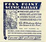
1953 to 1961. The Railway was in operation 

1962. Much of the railway land was destroyed by serious bushfires

1965.  Railway dismantled

1970. Mr Dan Cerchi purchased Lots 11 12 and 13. Lot 12 was the former Railway Land. After purchase, remnants of the railway had been discovered by Dan, including the car engine and a water tank.

1971. The road was realigned, with a crossover and kerbing built at the former railway site. 

c1972. Serious slippages of land occurred on Dan's holdings, with the main road becoming blocked. Repairs were made by the Government, but further slippages required major restoration of the road - additional drainage was built into the hillside. Dan recalls that at one stage there was concern that part of the road would break away and slide down the hill towards Mt Evelyn.

It was believed that these landslides were the result of the land being cleared for the railway infrastructure.

1974 The Government purchased sections of Dan's land and that of neighbouring owners. Financial compensation was made. This land then reverted to Government ownership, and in 1987 was integrated into the newly proclaimed National Park.

1987.The Dandenong Ranges National Park was proclaimed.

1997. Extensions to the NP were announced.


1847 to 1930s 
 
1847. Mount Dandenong was linked with the area that is now Mooroolbark by a tramway used for transporting sheep. 

1890s. Montrose was originally known as Double Pitts. Before 1892 the area was referred to as South Mooroolbark. Local landowner James Walker, whose son had a store in Colchester Rd, Kilsyth, named Rose Mont, called the settlement Montrose in the early 1890s.

1880s. The Government had surveyed  most of the area around Melbourne. This included large blocks of land for residential or farming purposes in the Dandenong Ranges 

1892. The Mt Dandenong area was opened up for settlement as part of the Village Settlement scheme

1899. The first land in the future railway area was granted to a Mr F. Shaw, as part of Crown allotments 76 and 76B

Early 1900s. Property was offered through the "Grant" and "VIllage Settlement" schemes and there was widespread purchase for speculative purposes. Residential development on the steep northern slopes of Mt Dandenoing was severely constrained due to the lack of road access.

1918. Work started on building the Mt Dandenong Tourist Rd, to link Montrose Villagee with Upper Ferntree Gully

1921. The  Tourist Rd opened - it was built mainly by returned servicemen from WWI in the years from 1918. Its introduction was associated with the appearance of many guest-houses, restaurants and small shops in towns through which it passed, making the mountain accessible by something known as the "motor car" which had started to appear in Melbourne! Prior to that. access was from Sheffield Rd to Five Ways (Kalorama), on the Coach Rd, which subsequently was renamed the Old Coach Rd.

1930s. Residential development occurred along the Tourist Rd, from Montrose Village to Kalorama Village.