|
|
|
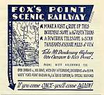
| From a promotional poster postcard - c1960. Note the flags and lights |
INTRODUCTION There
is very little detailed information publicly available about the construction of the railway, the rolling stock, and design
specifications. The only substantive written reference found was in an article in the "Melbourne Walker Magazine,
p64, Vol 27, 1956". This described some of the technical features, but the accuracy of this information could not
be verified. Some of this has been incorporated into this Project in good faith, in the absence of any other documentation. Much of this research has been done essentially by analysis
and inspection of photographs of 1956 and 1965. HISTORY The actual date of construction or commissioning
of the Railway is not known. It's
surmised that the commencement date was in 1953 (or 1952?), as a 1953 map of Greater Melbourne published by Broadbents shows
the railway in existence at that time. The original
owner was a Mr Neil Foxcroft, who had constructed a house near the top of the hill. He subsequently built a winch (funicular)
railway on the property, and his plan was to allow visitors to appreciate the scenery and panoramas.
He was assisted in management of the Railway by a friend. The Author believes that materials for building the house and railway were transported from Scenic
Cresent, a road located just above the property, It is thought it would have been impracticable, or impossible, to
carry building materials for the house and railway up the hill from the main road. It is possible that the property extended from Scenic Crescent downhill to
the main road. Scenic Crescent was opened up for
residential development around 1947, and is shown on maps of the Dandenongs of the time. It is a loop road, connecting with
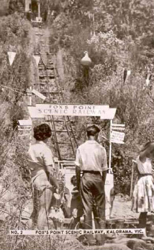
Inverness Rd, still unsealed, and today has many houses, with nice views overlooking the Yarra Valley. DESIGN The railway had a vertical
rise of 110 ft (34 metres). Passengers travelled 200 ft (61 metres) up the slope by cable car, to a lookout
area. This lookout area consisted
of two levels, with stone steps linking them. The lower level was next to the landing
point for the railway, consisting of an earthern section with a metal safety fence This was
the viewing platform, facing north, overlooking the main road. A telescope was here, through which aircraft
at Essendon airport could be seen, as well as Melbourne city buildings. It enabled visitors to tell the time by
the Lilydale clock, eight km away. .
On
the upper level platform was a refreshment kiosk, a museum, birds in an aviary, and a shed containing
the railway machinery, materials and power equipment. The owner's house was adjacent to the Lookout area The line was made of three steel rails - the outside
rails for the up or down car, and the single common rail in the middle. A passing siding
was located in the middle of the track and the track expanded to four rails at this
location. It appears that as one car was going up, the other was coming down, passing
each other in the middle. At the base, the track narrowed to two rails.There were two narrow stone access platforms at the foot
of the railway, very close to the edge of the main road. See
" After the Closure - Part 3" for information about the track layout at the foot of the incline. Two separate open carriages seating at least six
people were in use. Two cables were used on each carriage.
It is thought that descents were made by gravity, but no indication could be found about braking. Likewise,
it is not known what arrangements were in place for any failure of the prime mover, and if any "failsafe":
mechanism existed. POWER "The power plant of the railway was a 1927 model Oldsmobile
car engine on a chassis, which also actuated a generator for supplying electricity for
lighting up the railway and the landing platforms, as well as the house.
The
railway was controlled by a complicated system of levers and electric switches on the lookout platform.
It was reported (Melbourne Walker) that visiting engineers had expressed surprise and admiration
at the enterprise and ingenuity of Mr. Foxcroft in designing and constructing the whole
concern single handed". (Melbourne Walker)
There was a loudspeaker at the entrance at the road, from
which intending passengers could speak with the owner by a two-way system"
The railway
was open to visitors all day on Sundays and public holidays, every week-day afternoon,
and after 8 pm. on Saturdays"
LOOKOUT ROAD This runs westerly from Inverness Rd, north of the main road. It is not known whether the name derives
from the Scenic Railway Lookout, or marking a separate local observation point. Its date of construction is unknown. DANDENONG
RANGES NATIONAL PARK The Park was formally created on December 13 1987. It now includes
parcels of steep sided bushland in the vicinity of the railway alignment, extending up the hill from the main road to the
rear of residential properties on the north edge of Scenic Crescent. A local Community Fireguard and Weed reduction group assists with clearance of scrub and undergrowth
on the edges of the NP abutting adjacent properties..
|
|
|
| 1956 - publicity poster/postcard (SLV) |
PROMOTION AND CLOSURE
Advertisements
of the time vigorously promoted the railway, which was served by a local
bus service. Tourist buses stopped at the railway on their way back from the Mt
Dandenong summit. The bus stop is still there, on route 688, operated by Ventura
as the Croydon to Upper Ferntree Gully line. A
publicity postcard (see image) states that information could be obtained by telephone
from a Croydon number and that "Special Bookings" could be be made by mail from
a Kalorama PO Box. It is not known if there was an entry fee.
CLOSURE
In April
1958, a serious bushfire started in the scrub near the railway and burnt out a large area further up the hill. The Railway was forced to close around
1960/61 as it had been declared unsafe for passenger use by the authorities. In 1962, much of the surrounding bushland was
devastated by further disastrous bushfires, which impacted on the remains of the railway
and destroyed the owner's house.. There were other major fires in the area in 1963, 1972, 1973, 1974, 1983 and 1997.
|
COMMENTS The alignment of the railway is no longer apparent or defined, now hidden in dense bushland, within the National
Park precinct, and almost inaccessible from the main road. The steep hillside is covered in vegetation, fallen trees, rocks,
stumps, burnt-out logs, rubble, and thorny plants.. The entrance was about 200 m down from the former Telopea Native Garden,
which was on the north side of the Road. Inspection of the area, with a short scramble through the undergrowth from
the main road, during March 2014 by the author and John Thompson resulted in some images - see these in the "Present Day Images Part 2" page elsewhere in this Project! The site area was very diffciult to identify, as the Road had been widened
since the railway was dismantled. It was further widened sometime later in the early 1970s, and concrete kerbing and an access
point was constructed Much of the original short pathway to the base of the railway is now buried under
outfill from the road widening, reconstuction and excavations. Large stones in the grass next to the Road appear to have
formed part of the original access pathway. A "driveway" break of about two metres in the kerbing is believed
to be near the original entry point to the pathway. A local resident advised that the Lookout Pad and Platform were found
on a visit during 1976, along with two old tanks, metalwork, and sheet metal from a roof. His further advice is
that serious bushfires devastated the area in 1997, with little, or any, artefacts remaining. and cautions visitors
from attempting.to locate the actual Platform, due to the steep and rugged environment. John Thompson, whose 1965 photos are elsewhere in this Project, recollects that he first visited the Railway around
1955 on a family drive, and they discovered the waiting carriage sitting at the bottom, just off the main road.
He recalls hearing a voice from a loudspeaker inviting visitors to take the ride, which was then done at a "sedately
pace" up the hill. John adds that he would have been about 14 years old at the time
and, thanks to his Dad's
influence, already had a keen interest in anything that ran on rails.
He says that not long after their visit to the railway,
he and his Dad built a working model of
it using his extensive Meccano collection.The bottom of the incline was at floor level, the top on a bookshelf about
4 feet higher. He recalls that "it worked quite well". Over time, they built numerous working mechanical contrivances
but sadly,
never took any photos of them before pulling them apart to make something
else. It was a decade
later, in 1965, that John and a friend dismantled the rails.
|
|