Centenary of the O'Shannassy Water Supply System - 1913 to 2013 - a Pictorial Heritage

O'Shannassy Aqueduct Trail - Parrot Rd to Don Rd

Home
Introduction
1803 - Beginnings
1892 - Surrey Hills Reservoirs
1911 - Design and Construction
1911 - The O'Shannassy Weir
1914 - Maintenance and Operations
1923 - Bushfires, Landslips, and Floods
1924 - Modifications and Enlargements
1927 - Silvan Dam
1927 - Mt Evelyn Aqueduct
1928 - The O'Shannassy Reservoir
1929 - Upper Yarra Conduits
1931 - Silvan Inlet Aqueduct
1996 - Decommissioning
2006 - Pigging Project
2007 - O'Shannassy Aqueduct Trail - Overview
O'Shannassy Aqueduct Trail - Parrot Rd to Don Rd
O'Shannassy Aqueduct Trail - Don Road to Dee Rd
O'Shannassy Aqueduct Trail - Dee Rd to Sussex St
O'Shannassy Aqueduct Trail - Sussex St to Yuonga Rd
O'Shannassy Aqueduct Trail - Yuonga Rd to Donna Buang Rd
O'Shannassy Aqueduct Trail - Donna Buang Rd to Cement Creek Rd
O'Shannassy Aqueduct Trail - Cement Creek Rd to the Weir
The Present
Epilogue
Timeline
Bibliography
The Author's Websites
O'Shannassy Aqueduct Trail - Parrot Rd to Don Rd - 4 km

parrotrd1.jpg
Entrance at Parrot Rd (2012)

The western end of the Trail starts at a small car park at Parrot Rd, Woori Yallock.
 
It continues up and down hills for about 2 km where it reaches Ewert's Rd. It then crosses the Don River over a footbridge and continues up a stairway to Don Rd.

This Section is underground riveted pipe, parts of which are exposed at the edge of the trail.

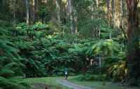
There are good views of the Ranges.

Points of Interest

  • Information board and map
  • Original riveted pipes exposed
  • Crossing at Ewart's Rd
  • Footbridge crossing over Don River
  • Stairway to Don Rd


parrotrd2.jpg
Info Board at Parrot Rd (2012)

donriverbridge.jpg
Trail crosses Don River (2012)

donriverpipe.jpg
Pipe, at Don River (2012)

ewsartsrd.jpg
Trail, looking west from Ewart's Rd (2012)

westfromdonrd.jpg
Don River, seen from footbridge (2012)

donriver.jpg
Don River, from footbridge (2012)

Contact the Author