Centenary of the O'Shannassy Water Supply System - 1913 to 2013 - a Pictorial Heritage

O'Shannassy Aqueduct Trail - Don Road to Dee Rd

Home
Introduction
1803 - Beginnings
1892 - Surrey Hills Reservoirs
1911 - Design and Construction
1911 - The O'Shannassy Weir
1914 - Maintenance and Operations
1923 - Bushfires, Landslips, and Floods
1924 - Modifications and Enlargements
1927 - Silvan Dam
1927 - Mt Evelyn Aqueduct
1928 - The O'Shannassy Reservoir
1929 - Upper Yarra Conduits
1931 - Silvan Inlet Aqueduct
1996 - Decommissioning
2006 - Pigging Project
2007 - O'Shannassy Aqueduct Trail - Overview
O'Shannassy Aqueduct Trail - Parrot Rd to Don Rd
O'Shannassy Aqueduct Trail - Don Road to Dee Rd
O'Shannassy Aqueduct Trail - Dee Rd to Sussex St
O'Shannassy Aqueduct Trail - Sussex St to Yuonga Rd
O'Shannassy Aqueduct Trail - Yuonga Rd to Donna Buang Rd
O'Shannassy Aqueduct Trail - Donna Buang Rd to Cement Creek Rd
O'Shannassy Aqueduct Trail - Cement Creek Rd to the Weir
The Present
Epilogue
Timeline
Bibliography
The Author's Websites

aa17deerd.jpg
Control gate west of Dee Rd (2012)

aa11deerd.jpg
Pipe exit, Dee Rd (2012)

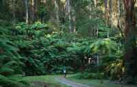
O'Shannassy Aqueduct Trail - Don Road to Dee Rd - 5.3 km

 
This Section starts at Don Rd, Woori Yallock. A small car park is adjacent to the access gate.
 
T'ravelling east, the Trail initially goes uphill, steeply, passing private properties - at this point, it is underground pipe. At the top of the hill, the open channel aqueduct starts at a transfer point - machinery once used for controlling water flow remains in situ.
 
The track then follows the open channel, reaching the Dee Rd access point, where it goes under the Dee River and emerges as open channel at the  picnic area and car park.
 
An old Management Hut remains standing, just before Dee Rd - the original Caretakers Cottage 'was on the south side of the open channel.
 
Points of Interest
  • Transfer station where pipe becomes open channel
  • Crossing of Platts Creek
  • Crossing of Frenchmans Creek
  • Crossing of Kennedys Creek
  • Crossing of McKechnies Creek
  • Management Hut near Dee Rd
  • Crosssing of Dee River
  • Aqueduct goes under the Dee River, then emerges as open channel

deesyphon.jpg
Dee Syphon 2012

deechlorineshed.jpg
Dee chlorine shed 2012

deecaretakershut.jpg
Dee caretaker's hut 2012

aa16deerd.jpg
Closeup of control gate, west of Dee Rd (2012)

aa14deerd.jpg
Maintenance shed, west of Dee Rd (2012)

aa10deerd.jpg
Open channel, west of Dee Rd (2012)

donrdgate.jpg
Gate at Don Rd (2012)

piteastofdonrd.jpg
Channel to pipe, east of Don Rd

pipeeastdonrd.jpg
Channel east of Don Rd (2012)

.

Contact the Author