Centenary of the O'Shannassy Water Supply System - 1913 to 2013 - a Pictorial Heritage

O'Shannassy Aqueduct Trail - Donna Buang Rd to Cement Creek Rd

Home
Introduction
1803 - Beginnings
1892 - Surrey Hills Reservoirs
1911 - Design and Construction
1911 - The O'Shannassy Weir
1914 - Maintenance and Operations
1923 - Bushfires, Landslips, and Floods
1924 - Modifications and Enlargements
1927 - Silvan Dam
1927 - Mt Evelyn Aqueduct
1928 - The O'Shannassy Reservoir
1929 - Upper Yarra Conduits
1931 - Silvan Inlet Aqueduct
1996 - Decommissioning
2006 - Pigging Project
2007 - O'Shannassy Aqueduct Trail - Overview
O'Shannassy Aqueduct Trail - Parrot Rd to Don Rd
O'Shannassy Aqueduct Trail - Don Road to Dee Rd
O'Shannassy Aqueduct Trail - Dee Rd to Sussex St
O'Shannassy Aqueduct Trail - Sussex St to Yuonga Rd
O'Shannassy Aqueduct Trail - Yuonga Rd to Donna Buang Rd
O'Shannassy Aqueduct Trail - Donna Buang Rd to Cement Creek Rd
O'Shannassy Aqueduct Trail - Cement Creek Rd to the Weir
The Present
Epilogue
Timeline
Bibliography
The Author's Websites

walkway.jpg
New Walkway, east of Donna Buang Rd (2012)

nearpickersgils.jpg
Pickersgill control gate (2012)

O'Shannassy Aqueduct Trail - Donna Buang Rd to Cement Cr eek Rd - 4.8 km
 
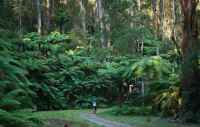
The Track folllows the open channel for about 1 km, reaching a newly constructed walkway, which passes through Rain Forest.
 
This walkway was constructed in 2012 - it is the final link in the track, passing over the tunnel carrying the pipe.
 
It continues on to the Cement Creek Rd access point, crossing the Western Branch of the Cement Creek.
 
Points of Interest
 
  • Anderson's Mill - bridge crossing (Pickersgills)
  • Walkway through Rainforest
  • Syphon

aa24cementcreeksyphon.jpg
Syphon, west of Cement Creek Rd (2012)

aa24cementcreekpit.jpg
Control machinery, west of Cement Creek Rd

aa23cementcreekwest.jpg
Cement Creek West Branch crossing (2012)

andersonsmilltramwaybridge2012.jpg
Robinson's Mill tramway bridge (2012)

bridgenearpickersgill.jpg
East of Donna Buang Rd - open channel enters pipe (2012)

nearwalkway.jpg
East of Donna Bujang Rd (2012)

.

aa22cementcreekstonewalls.jpg
Stone walls below syphon, west of Cement Creek Rd (2012)

aa21cementcreekmarker.jpg
Distance marker, west of Cement Creek Rd (2012)

aa20cemencreek.jpg
Control pit, west of Cement Creek Rd (2012)

donnabuangrdgate.jpg
Gate at Donna Buang Rd (2012)

.

Contact the Author