Good views of the Reservoir may be enjoyed from the public Lookout at the northern end of the dam wall. An information
display is located there, with historical photos and descriptions of the history and development of the dam.
GENERAL
The dam wall is a rolled earthfill dam with concrete corewall,
644 metres long and 219 metres at its base, blocking the valley of the Stony Creek. It is an off-river storage and has a relatively
small catchment of 555 ha. The maximum height of the embankment above the creek bed is 43 metres, and storage capacity is
40,000 megalitres. Bluestone rock from the nearby quarry has been used to cover the embankment, the downstream face of which
was reconstructed and extended in the 1980s. A vehicular pathway allows access across the dam wall, and a series of wells
along the wall lead to the drainage gallery within the wall itself.
Three of these are original, and the rest were
constructed later. The catchment comprises mixed eucalypt and other species, with a distinctive line of poplars planted along
the eastern edge of the reservoir.
Pine trees predominate on the slopes above the Depot, and along the Lilydale- Monbulk
road.
STONY CREEK
The Reservoir is built on the Stony
Creek Valley. The origin of the creek was in the high point to the south, near what is now Melbourne Water Gate 6A, and
flowed north down the valley, It then flowed westerly, entering the Olinda Creek.
Part of the creek survives today,
artificially fed via a pipe through the bottom of the reservoir wall, and passing under the Stonyford Rd where it joins the
Olinda Creek. This point is believed to be the original location of the ford.
CATCHMENTS AND WATER SUPPLY
Silvan is filled mainly from the Thomson, Upper Yarra and O'Shannassy
catchments in the east, and supplies other off-river storages such as Cardinia and Greenvale , and service reservoirs throughout
the metropolitan area. Water is brought to the Silvan by an open concrete channel from the O'Shannassy Aqueduct at Wandin
Yallock, and enters the reservoir via a short tunnel and the O'Shannassy Inlet works, and the Yarra Silvan Conduit (pipeline),
and the Yarra Valley Conduit (pipeline).
O'SHANNASSY INLET TOWER
This
is a concrete tower located on land at the north eastern corner of the reservoir, comprising six columns supporting a concrete
slab, based on an Egyptian design. The Egyptian style of construction, also employed in the Reservoir Outlet Tower and Stilling
Basins, is apparently based on the inherent strength of the design. In this tower, iron rings have been set into the ceiling
to enable the valves to be lifted, and this requires a structure that can withstand this kind of stress.
The structure contains wells in which four valves are located for the Reservoir, and two valves that control the
flow of water from the O'Shannassy aqueduct. The valves enable the aqueduct water to be redirected to the Preston Reservoir,
if the Silvan reservoir needs to be isolated at any time. A fibro cement shed with asbestos cement roofing is located adjacent
to the structure. It was formerly used to house a pump to service a small reservoir that provided water to the houses and
reservoir park.
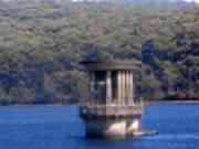
OUTLET CONTROL TOWER
This
is located in the reservoir, and is an oval-shaped concrete structure featuring a distinctive Egyptian design reflecting a
similar architectural theme as the O'Shannassy Inlet Tower. Unlike the O'Shannassy Inlet Tower this tower features straight
rounded columns, a low decorative wall, and two wells in which the water hydraulics system internal valve controls are located.
The external valves are now operated mechanically, but the ratchets once used to turn the valves by hand are still located
in the tower.
CABLE DRUM AND CABLE
This
as apparently part of the Aer
ial Ropeway system that carried goods from Mt Evelyn Railway Station to the dam site during construction. It is located about 30 metres
to the north east of the dam wall. A galvanised iron shelter has collapsed on the timber drum, but the drum and metal cable
appears to be intact. The drum measures approximately 2 metres in diameter.