|
|
 |
|
|
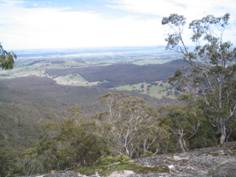
| My Buangor from Mt Sugarloaf - 2006 |
Two Mile Track. (180
km W). Western Highway, Beaufort, Fern Tree Waterfalls Rd, Bailes Picnic Ground. Follow signed circuit "Two Mile Track",
passing Waterfall, and return. Good mountain forest environment. (3
km, 1 hr, January 2006)
Photos | Map
Mt Buangor Summit Walk. (180 km W). Western Highway, Beaufort,
Raglan, Main Mt. Cole Rd, Dawson Track, to small picnic ground at Mugwamp. Follow Mt. Buangor Track to summit and return.
Really superb views to the Grampians, Mt. Langi Ghiran and in between! Note: Dawson Track is suited to high ground clearance 4WD, stony and
potholed. Care needed if using 2WD! (6 km, 1.5 hrs, February 2006)
Photos | Map
Mt Sugarloaf Summit Walk. (180 km W). Western Highway, Beaufort,
Fern Tree Waterfalls Rd, Bailes Picnic Ground. Follow signed track to Mt. Sugarloaf and return. Caution - track is indistinct
in parts - check the markers. Superb views from Summit. (6 km,
October 2005, 2 hrs).
Photos | Map
|
|
|
|
Distances to the start of walks, from Melbourne, are in brackets against
their descriptions
|
|
|
|

