|
|
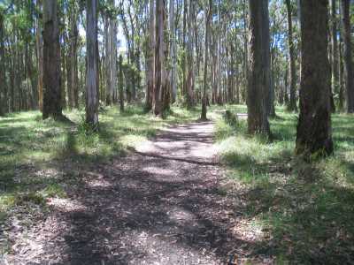
| One Tree Hill Summit - March 2007 |
Chandlers Hill Walk (25
km E). Burwood Highway, Ferntree Gully, Tremont, One Tree Hill Rd, car park at One Tree Hill summit. Follow Dyson's
Track, Outlook Track, View Track, Chandlers Track, to summit of Chandlers Hill (400m). Return to car park. Tantalising views through tall timber towards Mt Dandenong, Kinglake, and the Doongala Section of the Park.
Note: Dyson's Track is steep! (4 km, 1 hr, February 2007).
Photos | Map
Kokoda Track Memorial Walk. (25 km E). Burwood Highway,
Ferntree Gully, main car park. Ascend signed "Kokoda Track Memorial Walk", return via Lyrebird Track. This
is a world-famous walk, with many interpretative signs, passing through tall timber.
Caution: This Track is VERY steep and challening, and offers vood training for Trekking in
the Himalayas!. (3 km, 1.5 hrs, February 2007).
Photos | Map
Ramu Track. (25 km E). Burwood Highway, Ferntree Gully,
Mt Dandenong Tourist Rd, Churchill Drive, to car park at One Tree Hill. Go through Gate, descend
along Ramu Avenue, continue along Bellview Terrace to junction with Boulevard Track. Return to start. Good
forest environment. Warning: track
is very steep! ( 4 km, 1 hr, April 2006).
Photos | Map
Bellview Track. (25 km E). Burwood Highway, Ferntree Gully, to
main car park. Ascend Bellview Terrace, to Boulevard, then follow Lantern Track, retun to start.
Good views across eastern suburbs. Warning: track is very steep! (3 km, 1 hr, April
2006)
Photos | Map
Around One Tree Hill. (25 km E). Burwood Highway, Ferntree Gully,
Mt Dandenong Tourist Rd, Churchill Drive, to car park at One Tree Hill. Descend Tyson's Track, join
Outlook Track, return to car park via Ramu Track.Warning:
tracks are very steep! Pleasant forest environment.(3
km, 1 hr, March 2007)
Photos | Map
One Tree Hill Explorer. (25 km E). Burwood
Highway, Ferntree Gully, Mt Dandenong Tourist Rd, Churchill Drive, to small layoff at gate on Poacher's
Track, about 200m from the One Tree Hill Picnic Ground. Follow this track, then descend Lybebird Tk, then Link Tk, ascend
Ramu Avenue, into Poacher's Tk, return to car. Views to Melbourne
from Ramu Avenue, forest environment. birds. (3 km, 1 hr, May 2008).
Photos | Map
Living Bush Trail (also
known as Nature Trail). (25 km E). Burwood Highway, Ferntree Gully, main car park.Staet at childrens'
playground, proceed on signed circuit track - this follows Rambler's Tk, Musk Ave, Telegraph Tk, and Acacia Tk. Tall timber, ferns, creek. (3 km, May 2008, 1 hr)
Photos | Map
Alpine Track. (25 km E). Burwood Highway, Ferntree Gully, Mt
Dandenong Tourist Rd, Churchill Drive, Mt Erin Rd, Janeswell Avenue, to small car park. Walk down Janeswell Av, past
burnt trees, reaching locked gate, descend steeply to junction with Alpine Track (not signposted), Turn left, proceed to a
gate, then reach the Mountain Highway and return. Forest, fern gullies, fern trees.
This area was devastated by the January 1997 fires and is slowly regenerating
- many houses in Janeswell Avenue and nearby were destroyed, and three persons lost their lives.Note: This
is part of the long Western Slopes Walking Track. (4 km, 1.5 hrs, July 2007).
Photos | Map
Tremont Hill Track. (25 km E). Burwood Highway,
Ferntree Gully, Mt Dandenong Tourist Rd, Tremont, to small car park in Hughes St. Go through gate, follow Tremont Hill Track
track south to the junction with Hughes St. Return. Nice views to the west and east, bushland,
picnic table at summit. (3 km, 1 hr, November 2007)
Photos | Map
|

