|
|
 |
|
|
| Tomahawk Creek Track |
The walks described on this page are to places outside the prinicipal
National Parks, Regional Parks and State Parks in the Eastern Region
PAUL'S RANGE STATE FOREST - STEEL'S CREEK DISTRICT
Southern Tracks.
(50 km NE). Yarra Glen, Melba Highway, Old Toolangi Rd, Beach's Lane, to signed entrance to Forest and small car
park at Paul's Lane junction. Follow signposted Paul's Range Track, then ascend (very steep) up Loop Tk, reaching junction
with Ridge Tk. This is the highest point on this walk - 375m - the car park is at 166m. Explore Ridge Tk for about 500m, then
return to car. Bushland, good views from Ridge Tk to the Great Dividing Range and farnland.
Track is seriously eroded in parts by trailbike activity. (3 km, 1 hr, May 2008).
Photos Map - Melways
KIRTH KILN PARK
Note! The
Park is very large, 3500 ha, and offers a marvellous selection of hiking tracks, some of which are shared with horses and
cyclists.
Tom's Track.
(65 km E) Maroondah Highway, Woori Yallock, Lusatia Park Rd, Launching Place-Gembrook Rd, to small car park, next to
signed Tom's Track. Descend this track, reaching Clark's Creek and return. Interesting forest environment. (4 km, 1 hr,
April 2011).
Photos Map
Spencer Track. (65 km E). Gembrook, Beenak Rd, Soldiers Rd, to small car park
at junction with unsigned Spencer Tk. Follow tk south to Tentpole Rd and return. Interesting
bushland, spring wildflowers. Note: This is one of many shorter
ungated tracks in this section of the Park, shared with walkers and horseriders. 2 km, 45 mins, September 2007).
Photos Map
Monk's Fireline Track.
(65 km E). Gembrook, then Gembrook-Woori Yallock Rd, past Kuth Kiln
picnic ground, then reaching signposted track on the left. Follow track to its end at Boundary rd and return. Good forest environment, through former logging region, passing two large dams. (4
km, 1.5 hrs, September 2008).
Photos Map
Gilwell Track. (65
km E). Gembrook, Beenak Rd, to car park at junction with Shepherd Ck Rd, to signed/gated track. Follow tk to Gembrook-Launching
Place rd and return. Pleasant forest, spring wildflowers, large granite boulders, Clarke's
Creek. (2 km, 45 mins, September 2007).
Photos Map
Possum Track. (65
km E). Gembrook, Beenak Rd, to small car park at sign marked "Possum Track". Go throuigh gate, follow track to the nothern
end at Boundary Rd, and return the same way. Excellent bushland, ferns, fern gullies, large
dam, Shepherd's Creek. Muddy after wet weather! (4 km, 1 hr, September 2007).
Photos Map
Firewood Track. (65 km
E). Gembrook, then Gembrook-Woori Yallock Rd, Beenak Rd, to small car park next to gated/signed
Firewood Tk. Follow track to its junction with Thom's Tk and return. The track crosses the unsigned Kurth Kiln firebreak and
Camp Tks. Forest environment, ferns, tree ferns, spring wildflowers.
(3 km, 1 hr, September 2007).
Photos MapThornton Track -(65 km E). This is an interesting circuit walk, through forest and fern gullies, adjacent to the Tomahawk Creek, and includes the
historical Kurth Kiln and cottages. Access: Gembrook, then Gembrook-Woori Yallock Rd. Walk is signposted - start at the
Kurth Kiln picnic ground. After reaching the footbridge, cross the Tomahawk Creek and return via Scout Camp Rd, inspect the
Kiln. (4 km, 1 hr, August 2009)
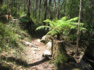
Tomahawk Creek Track (65 km E). This is an excellent
walk, following the Tomahawk Creek valley in a circuit. Access: Gembrook, Gembrook-Woori Yallock Rd, to car park
at Kirth Kiln Visitor Centre. Start on the right of the bridge, follow the defined lower level track through forest until
a footbridge is reached, cross bridge, and return to car park on the opposite bank. There is a short spur track to the Shepherd's
Lane road just past the bridge. Track goes through forest, lush green fern gullies, and
passes a gorge, waterfalls, and large granite rock formations. (4 km, March 2009, 1
hr).
Photos | Map
Shiprock Falls. (65 km E). Maroondah
Highway, Lilydale, Woori Yallock, Lusatia Park Rd, to small car park opposite Shiprock Falls track. Follow track to Falls
and return. Explore minor tracks and huge granite boulders at top of falls. Track has been upgraded and an observation platform
constructed. Short interesting walk through forest, falls view. (1
km, 30 mins, Apr 2009)
Photos | Map
Watermill Bush Camp. (65 km E). Maroondah Highway,
Lilydale, Woori Yallock, Lusatia Park Rd, Beenak Rd, to small car park at locked gate at entrance to unsigned Watermill Track.
Descend track to where it ends at the Bush Camp, on the McCrea Creek. There is a change in altitude from 280m to 227m.
Muddy after wet weather. Good forest environment, wildflowers in spring.
(3 km, 1 hr, Sep 2007)
Photos | Map
Waterchannel Track - Northern Section. (65 km E). Maroondah
Highway, Lilydale, Woori Yallock, Lusatia Park Rd, Beenak Rd, to Kurth Kiln picnic area. Then along Soldiers Rd and Scout
Camp Rd, to locked gate at entrance to signed Waterchannel Track. Descend track, passing a water point and remains of the
old water channel, to its end at the Woori Yallock Rd and return. Good
bushland environment, former logging area, many Banksias! (3 km, 1 hr, August 2009)
Photos | Map
Waterchannel Track - Southern Section (65 km E). Maroondah
Highway, Lilydale, Woori Yallock, Lusatia Park Rd, Gembropok Rd, to locked gate at entrance to signed Waterchannel Track.
Descend track, passing the Tomahawk Creek and billabong, then return. Good bushland
environment, former logging area, many Banksias! (3 km, 1 hr, April 2011)
YEA REGION
Yea River Walk (80
km NE). This is a pleasant nature circuit walk through the Yea River Wetlands. Walk starts at the signposted access at
the eastern end of the Yea town, passing through remnant forest, adjacent to the Yea River. The walk includes the suspension bridge and boardwalks, and Interesting features are marked with interpretative
signs. From Melbourne, Yea is reached from the Melba Highway, through Lilydale and Yarra Glen. (2
km, September 2006)
WARBURTON REGION
Warburton - Yarra River Walk (80 km E). Start at the main Bridge at the eastern end of Warburton township,
follow the signposted track westerly on the south bank to the terminus, near the Golf Course. Cross the Yarra at this
point and return along the north bank to the Footbridge. Cross the Yarra again, and return to the starting point.
The track is maintained by the Warburton Advancement League,
and passes through fern areas and forest. Many ducks and geese will greet
you on your journey! (6 km, 2 hrs, August 2006)
Warburton - River Trail (80 km E). Start at the
main bridge at eastern end of Warburton township. Locate sign, proceed through camping ground, then follow Trail adjacent
to river. Trail follows alignment of the former Timber Tramway which ran from Big Pat's Creek to Warburton.
It crosses Wood's Point Rd, then runs next to the road, ending just past the bridge. Cross road, follow Riverside Drive
back to Warburton. Excellent views of the river. (7 km, 2
hrs, July 2006)
Photo Album | Map
Shorter walk: As above, but do not proceed past the junction of Wood's
Point Rd.
Photo Album (3 km, 1 hr - August 2008)
Yarra Junction - Little Yarra Riverside Walk
(60 km east) Start at the crossing of the Lilydale-Warburton Rail Trail at Corduroy Rd, west of the town centre.
Follow this Trail to the Yarra Valley Museum. The signed Riverside Walk starts immediately behind the Museum and follows
the river for about 1 km. It passes the commemorative sculpture for the Meeting Place of the Manna Gum Aboriginal people. Return the same way. The Museum is only open on certain days, and a small admission fee is charged. Good views of the river, and north across the Don Valley, to Ben Cairn, the Warramate Hills, and Mt Toolebewong.
(4 km, one hour, August 2011).
Photo Album | Map - Melways.
HODDLE'S CREEK REGION
Hoddle's Creek Forest Trail.
(50 km E). Access: Warburton Highway, Launching Place-Gembrook Rd, Parkinson's Rd, to small car park at signposted
reserve. Go through gate, follow the main fie access track to its end at Hazeldene Rd, and return. A
pleasant hike along the ridge, through remnant bushland. (1 hr, October 2006, 4 km)
Photos | Map - Melways
YELLINGBO REGION
Yellingbo Nature Conservation Reserve.
(50 km E). Warburton Highway, Wandin, Beenak Rd, Macclesfield Rd, to small car park at signed/gated entrance to Reserve.
Climb over stile, follow access road to picnic ground adjacent to community educational centre and Parks Vic depot..
Follow tracks along Woori Yallock Creek and return. This is the habitat of the endangered Helmeted Honeyeater, and Leadbeater
Possum. Guided tours for small groups may be arranged with Parks Vic. Passive recreational activities encouraged. This is
the western section of the Reserve. Bushland environment, wetlands, billabongs, creek, bridges,
forest, ferns, fern gullies. (4 km, 1 hr, September 2007).
Photos | Map - Melways
CATHEDRAL RANGE STATE PARK
Ned's Peak Walk. (120 km E). Maroondah Highway, Healesville, Cathedral
Rd, to main picnic ground. Ascend signed track to Ned's Peak and return. Forest environment,
good views from summit. Quite steep! (6 km, 2 hrs, December 2005).
Photos | Map
WEST GIPPSLAND REGION
Mt. Cannibal Flora and Fauna Reserve - Garfield. (90
km E). Princes Freeway, Garfield North Rd, to small car park at signed reserve. Ascend track to ridge and return (loop
circuit). There are three Lookouts - North, South, and Rotary.Nice forest, excellent views
from summit to Bunyip State Forest. (3 km, 1 hr, January 2009)
Photos : Map - Rooftops Series: Yarra Valley - West Gippsland
NEWLY
OPENED WALK! Cardinia Aqueduct Trail - Pakenham. (50 km E). Prince's Highway, Pakenham,
north alongn Thewlis Rd, to small car park at gated eastern entrance to the Trail. Follow trail along disused Tarago-Beaconsfield
Aqueduct to western gate at Officer Rd and return. Pleasant bushland environment, nice views
across farmland to Westernport Bay. This is
a new Trail, managed by Cardinia Shire, and opened in 2006.
(4 km, 1 hr, August 2007).
Upper Pakenham Lake Reserve. (50 km E). Prince's Highway, Pakenham,
north along Army Rd, turn left into Lilliput Lane, to car park and picnic ground at Lake Reserve. Follow circuit track around
Lake. Waterfowl, remnant forest, nice views of lake. (2 km, 30 mins, August
2007)Photos | Map - see Melways
Chamber's Flora and Fauna Park - Upper Pakenham. (55 km SE). Princes Highway,
Beaconsfield, Upper Beaconsfield, Beaconsfield-Emerald Rd, Bourkes Creek Rd, to large picnic ground at entrance to Park. Follow
Kangaroo Trail, Lyrebird Walk. Wombat Track, Acacia Walk back to start. Distinctive remnant
bushland envirnoment. (3 km, 1 hr, March 2006). Photos | Map - Melways
Mine Shaft Forest Reserve - Macclesfield. (50 km E). Belgrave,
Emerald, Macclesfield Rd, Macclesfield, Tschampions Rd, Yululga Drive, Mine Shaft Rd, to small carpark at gate of Reserve.
Explore the Reserve via various tracks - once a gold mining area in the 1850s, later used for logging. Remains of mine shafts may be seen. (1 km, 30 mins, July 2007)
Yarrabubba Forest Reserve - Maryknoll. (60 km E). Prince's Highway,
Pakenham, Snell Rd, to small carpark at Metz Corner. Follow signed walking track to Wingadee Rd and return. Pleasant remnant bushland, Back Creek, boardwalks, bridges,views from a high point across Reserve to the west. (4
km, 1 hr, August 2007).
Photos | Map -see Melways
Critchley Parker Junior Forest Reserve - Upper Beaconsfield. ( 50 km
E). Monash Freeway, Berwick, Beaconsfield, Beaconsfield-Emerald Rd, Upper Beaconsfield, left at St,. Georges's Rd, to
signed carpark at Reserve entrance. Follow track westerly to right. Inspect the Ash Wednesday February 16 1983 Memorial to
the 21 firefighters who died that day in the bushfires which destroyed 9200 hectares in the Upper Beaconsfield region. Follow loop
track along Park boundary back to start. Regrowth forest environment, views across
the valley south towards Beaconsfield and Westernport Bay. (3 km, 1 hr, August
2007)
Photos | Map -see Melways Wilson Botanic Park - Berwick. (40 km E).
Princes Highway, Berwick, to large car park. Follow well-signposted foot-tracks around the Park - Hilltop Rd, Basalt Rd, past
the Anniversary and Basalt Lakes, Hoo Hoo Lookout, Directional Marker Lookout, Ben's Lookout, Birdhide, Ampitheatre, basalt
cliffs. Park is on the site of the former bluestone quarry, and managed by Casey Shire. Excellent
views in all directions from Hilltop Rd and the three lookouts. (5 km, 1.5 hrs, Aug 2007).
Beaconsfield Flora and Fauna Reserve.
(45 km E). Monash Freeway, Princes Highway, Berwick, Beaconsfield, Emerald Rd, to small car park at signed entrance to
the reserve just past the oval. Follow foot-tracks past interpretative notices and return.
Tracks cross Cardinia Ck and Brisbane Ck - wetland, bushland, creek views, birdlife. (4 km, 1 hr, September
2007).
Photos | Map - see Melways
Bunyip Nature Sanctuary. (70 km E). Monash Freeway, south into
Doran Rd (Bunyip), to signed car park / picnic area at sanctuary - the site was formerly part of the KooWeeRup Swamp. Wetland, birds, lizards, mammals, frogs, snakes, walking tracks, creek, bridges, views
to the Bunyip State Park, Black Range, Mt Towt, and Mt Cannibal. A seldom-visited 13 hectare
nature reserve! (1 km, 1 hr exploring, September 2007).
Photos | Map - see Melways or RACV Victoria
Labertouche Creek Fauna and Flora Reserve. (80 km E). Princes
Highway, Labertouche Rd, Jackson's Track, to small car park at junction with Fisher's Rd. Reserve is signed. Follow walking
track beside Labertouche Ck to end of Reserve and return. Interesting bushland, creek, spring
wildflowers, good views across open farnland to the eastern end of the Bunyip State Park. (3 km,
1 hr, September 2007).
Photos | Map - see Melways or RACV Victoria
NOOJEE STATE FOREST
Toorongo Falls. (100 km E). Warburton Highway, Yarra Junction,
Powelltown, Noojee, Mt Baw Baw Rd, Toorongo Falls Rd, to car park and picnic ground. Follow signed circuit track to Amphitheatre
Falls and Toorongo Falls. A superb walk through forest, ferns, with excellent views of both
falls from observation platforms. (2.5 km, 1 hr, September 2007).
SOUTH GIPPSLAND REGION
Lyrebird Forest Walk - Mirboo North.
(140 km E). NEW WALK OPENED SEPTEMBER 2007. South Gippsland Highway, Leongatha, Strzelecki
Highway, to large picnic area 5 km north of Mirboo North town. Follow signed circuit foot-track (the "Short Trail") along
Little Morwell River, passing through Coral Fern Gully. Excellent forest environment, bridges,
fern gullies, tree ferns. A longer signed walk of about 5 km may be undertaken. An alternative roure
to the Walk is via the Prince's Highway, to Trafalgar, then through Thorpdale - stop at the Mt. Speed Lookout for marvellous
videws across the Latrobe Valley. (3 km, 1 hr, October 2007)
Photos | Map Mt Worth State Park (120 km SE). Princes Freeway, Darnum Rd,
Cloverlea, to Moonlight Creek car park/picnic ground. Follow signed tracks to Trevorrow's Mill site, Giant's Circuit, and
Moonlight Creek Tk to site of Maslin's Mill. Several other tracks may be explored, starting at the car park. Wet forest, fern
gullies, lyrebirds,creeks, relics of old mills of the 1920s. Maps available at the information kiosk in the picnic
ground. Superb forest environment, excellent views from the approach road north to
the Victorian Alps over La Trobe Valley. ( 4 km, 1.5 hrs, April 2009)
Photos | Visitor Guide
MT BUFFALO NATIONAL PARK
Walks from the Chalet Vistor Centre. (320 km
NE). Mt Buffalo Rd, to Chalet car park. Several shorter walks, all signposted, start here, offering excellent views across
the valley to the high country. They include the spectacular views from several lookouts
- Bent's, Echo Point, Hang Glider, Billson's, and the Haunted Gorge. About 2 km, one hour. Another walk
is the circuit around the Gorge.
Map | Photos
Laka Catani Walk
(320 km NE). Mt Buffalo Rd. Circuit hike around Lake from picnic area car park, passes the Dam, through Alpine meadows. (3
km, 1 hr, December 2013)
The Monolith Summit and Circuit Walk (320 km
NE). Mt Buffalo Rd, Cresta Valley Day Visitor Centre, follow one of two signed tracks to Monolith Summit and Viewpoint,
return via the loop trail back to Mt Buffalo Rd. Track is steep in parts, follows steps in a ravine, altitude change is 140
m from road.. Excellent views in all directions from the Summit. (3 km, 1.5 hrs, December 2011)
South Buffalo Viewpoint. (320 km NE). Mt Buffalo Rd, Cresta Valley
Day Visitor Centre car park. Follow signed track to the viewpoint and return. Excellent
views across the Plateau amd beyond. Track passes through Alpine grassy plains and Snow Gum woodlands.
(8 km, 2 hrs, April 2008)
Map | PhotosMt Dunn (320 km NE). Mt Buffalo Rd, to small car park
opposite Lake Catani. Follow signed Long Plain Track to Mt Dunn and return. Excellent views
from the summit of Mt Dunn across the Plateau and Park. The final section is up steel ladders.The Long
Plain Track follows the Eurobin Creek, passing through Alpine grassy meadows. (8 km, 3 hrs, October 2008)
Buffalo Gorge. (320 km NE). Mt Buffalo Rd, to the Chalet car park/picnic
area. Follow signed tracks around the top of the Gorge to the various lookouts. Superb
views across the Buckland Valley. Note: Admission fee payable to enter the Park. (2 km, 1 hr,
April 2008)
Photos | MapRollason's Falls. (320 km NE). Mt Buffalo Rd, to the car
park/picnic area. Descene signed track to the Buffalo Creek and Falls (Upper and Lower Falls)Track is steep in sections
- excellent views of the Falls at the bottom. (4 km, 1.5 hrs, August 2009)
Photos | Map
Corrall Peak, Mahomet's Tomb and the Sentinel (350 km NE).
Mt Buffalo Rd to car park at base of the Cathedral Rock. Follow signed track to Corrall Alpine Meadow, then to Corrall
Peak, Mahomet's Tomb and the Sentinel. Return to car park. Superb Alpine views!
The lower section of the track is formed from steps - the top section is steep and rough. (4 km, 1.5 hrs, April 2010)
Photos | Map
The Cathedral and the Hump (350 km NE). Mt Buffalo Rd to car park
at base of the Cathedral Rock. Ascend signed track to the Cathedral Rock lookout, then continue on to the Hump. Spectacular Alpine views.
Track is steep in sections. (3 km, 1.5 hrs, April 2010)
BEECHWORTH REGION
Woolshed Falls Walk. (275 km NE). Beechworth, to car park
at the Powder Battery on Gorge Rd. This is the Beechworth Historic Park - follow signed foot-track, reaching Gorge Rd, walk
along this road, over the old bridge, past the Spring Creek Cascades, to the continuation of the walking track. Descend steeply, reaching
flat land. Follow the orange markers to the end of the track, past farms and the creek. Cross the main road, pick
up the Woolshed Falls Track, continue to the Falls car park and picnic area, view the Falls. Return to start. Excellent views of the Woolshed Valley, the Falls, old goldmine artifacts, forest,
cliffs, Cascades. (10 km, 3 hrs, June 9 2008). Photos | Map
White Box Track - Chiltern-Mt. Pilot National Park (250 km NE). Hume
Freeway, Chiltern, Chiltern-Beechworth Rd, Lancashire Gap Rd, Honeyeater Picnic ground/car park. Follow signed White
Box Track, clockwise circuit. Forest environment, relics of old gold mines, many birds,
view point, footbridges. (8 km, 2 hrs, December 2008)
Photos | Map - download from Parks Victoria
Mt Pilot Summit - Chiltern-Mt Pilot National Park (250 km NE).
Hume Freeway, Chiltern, Chiltern-Beechworth Rd, turn off on Old Coach rd, then to Summit Car Park/picnic area. Follow
walking track to summit. Magnificent views
in all directions. (2 km, December 2008, 1 hr) Photos | Map - VicRoad or Melways
MT DISAPPOIINTMENT STATE FOREST
Mt Disappointment Summit Walk. (60 km N). Hume Freeway, Heathcote
Junction, Wallan East, Wandong, Main Mountain Rd, Mt Disappointment Rd, to car park at Blair's Hut picnic ground. Walk up
Mt Disappointment Rd to its end at junction with Board Rd. Follow jeep track to large cleared space at heli-pad. This is the
lookout - good views to Melbourne,Whiittlesea and Yan Yean Reservoir, over the prohibited access Melbourne Water firebreak which
leads down to the Tourourrong Reservoir. Regrowth forest environment, Hume and Hovell information
board at Blair's Hut, views from summit. (3 km, 1 hr, July 5 2008)
Note: The Mt Disappointment State Forest has innumerable walking tracks
and public access management roads, many dating back to the uncontrolled logging era. Sone tracks are closed in winter. Care
is needed, due to the shared use of tracks and roads by trail-bike riders and young children on minature four-wheeled motorized
buggies.)
Photos | Map - see Parks Victoria website Strath Creek Falls Gorge Walk. (60 km N). Hume
Freeway, Heathcote Junction, Strath Creek Rd, turn south at Murchison Spur Rd, to junction with Strath Falls Track. Park
here. Walk to Falls viewing area and return. Rugged gorge, rock formations, falls, forest
environment. (3 km, 1 hr, July 2008).
Photos | Map - see Parks Victoria website Anderson Garden Walks. (60 km N). Hume Freeway,
Clonbinane Rd, to Anderson Garden Picnic Ground and car park, on Boundary Rd, at Sunday Creek.
Walk 1: Walk up Boundary Rd, reaching viewpoint at junction with Harry's Head West Rd. Return to car
park. Walk 2: From the car park, follow signed Walking Track along the Sunday Creek Gully. Visit
the concrete weir . This track continues towards the large Sunday Creek Reservoir. Return to car park. Excellent panoramas from the viewpoint. Pleasant bushland, regrowth forest, creek views.
(4 km, 1.5 hrs, August 2008)Photos | Map - see Parks Victoria website
WHITFIELD REGION
Wabonga Plateau State Forest - Paradise
Falls. (350 km NE). Whitfield, Cheshunt, then along the Falls Rd (unsealed), reaching the carpark
and picnic area. Descend inti the Gorge down the Falls Walking Track, reaching the viewing area at the base of the
Falls. Return to car. The Falls drop about 30 metres down a vertical cliff. The flow may be low in dry weather. The cliff face is rugged - good views towards the Alps. (1.5 km, 30 mins, December
2009.
Power's Lookout Reserve (350
km NE). Whitfield, then along the Mansfield Rd, turn off to Power's Reserve, to car park and picnic area. There are two
Lookouts - the main platform is at the car park, the northern platform is along a walking track, with steel ladders and staircases.
An info board at the carpark provides details about the Reserve, and its geological formation. Spectacular
views from both Lookouts over the King River Valley towards the Alps and Buffalo Massif. (45 mins,
2 km, December 2009).
Photos | Map - see Parks Victoria website
BRIGHT REGION
Wandiligong Goldfields Walk.(350 km NE). Bright, then to Wandiligong,
then to signed Goldfields Walk. Follow main circuit track next to Creek, passing the Suspension Bridge, Birdhide, and
Chinese Bridge, return to car. Track passes through the former goldfields area. (3
km, 1 hr, April 2010)
MT BEAUTY REGION
Mt Beauty Pondage Walk. This walk starts at the Mt Beauty Village Centre
and is a circuit around the Pondage. The Pondage is part oif the Kiewa Hydroelectric Scheme.
Nice views to the Alps and nearer hills. (2 km, 45 mins, December 2010) Photos
HARRIETVILLE REGION
Bon Accord Spur Track - Familiarization Walk
(400 km NE). Great Alpine Rd to Harrietville, then along Bon Accord
Rd, leaving the car at the start of the unsealed track wjich runs alongside the Ovens River. Follow this track for
about 1 km to the information board and intention book. The Bon Accord Spur Track starts
here, and continues 10 km up the mountain, eventually reaching the Razorback Track, and then on to Mt Feathertop. This familiarization walk is steep in the upper sedctions,and provides a good introduction to the region,
once a gold mining precinct. Turnaround point is aboput 1 km from the info board. (3 km,one hour,
December 2011)
Map - see Rooftops | Photos
|
|
|
|
Distances to the start of walks, from Melbourne, are in brackets against
their descriptions
|
|
|
|

