Baldry Crossing Track (85 km S). Access: Mornington Peninsula Freeway, Baldry Rd, Baldry Crossing Picnic Ground/Carpark.
Walk starts directly opposite carpark. It weaves its way through lush fern forests,
over boardwalks and creeks.
(5 km, 1.5 hrs, December 2006).
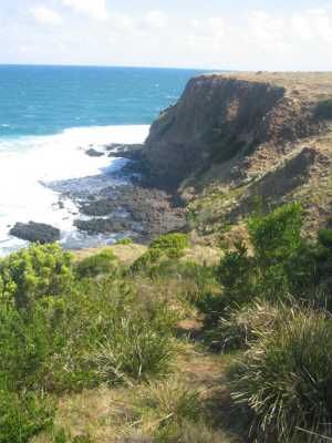
Fingal Beach (90
km S). Access: Hastings, Flinders, Cape Schank Rd, Pines Picnic area and car park. Follow signposted Fingal
Beach foot-track to the ocean beach - steep descent over many steps. Return via the longer cliff-top circuit.
Splendid views of the coastline. (4 km, January 2008, 2 hrs)
Fingal Beach (90
km S). (Variation of above walk). Access: Hastings, Flinders,
Cape Schank Rd, Pines Picnic area and car park. Follow signposted Fingal Beach foot-track to the ocean beach - steep
descent of about 1 km down many steps and stairway. Proceed along beach to the rugged rocks towards Gunnamatta. (Note: It is possible to walk through to Gunnamatta Beach along the beach at
low tide). Return up the stairway, then via the short-cut track which leads into the Pines picnic area. Splendid views of the coastline. (4 km, January 2010, 2 hrs)
Cape Schank Boardwalk and Staircase (90 km S). Access:
Hastings, Flinders, Cape Schank Rd, main car park (fee payable). Follow track to ocean. Very
good views of Pulpit Rock and coastline. (3 km, October 2006, 1 hr)
Flinder's Coast Blowhole Track (90 km S). Access: Flinders,
Rosebud Rd, to small car park near Razorback Rd. Follow track down staircase to the beach and rock platforms. Continue east on
beach to the headland. Return via the western headland. Very good coastal views.
(3 km,
March 2009, 1 hr).
Cape Schank to Bushranger's Bay Walk (90 km S). Access:
Flinders, Rosebud Rd, Cape Schank Rd, main carpark. Follow track along the clifftop to a junction with the Main Creek Track.
Descend to Main Creek beach on Bushranger's Bay. Return to Cape Schank. Superb coastal views
from the clifftop.(7 km, November 2006, 2 hrs)
Main Creek Walking Track to Bushrangers Bay. (90 km S).
Access: Hastings, Flinders-Rosebud Rd, to small car park, signposted to Bushrangers Bay. This is part of the very long
Two Bay's Walking Track. Follow the track south, turn left at junction with the track to Cape Schank. Descend to Bushrangers
Bay Beach, walk along beach to Elephant Rock and return the same way. Beautiful views of the coast.
(8 km, 2 hrs, October 2006)
Photos | Map
Tea Tree Creek Bay - Flinders Coast. (90
km S). Access: Flinders, Rosebud Rd, to small carpark near Keys Rd. Descend signed track and staircase to the
beach. Follow beach to the East Bluff and return to the top of the staircase. Continue west along a footpad to the top of
the West Bluff, and return to car. Excellent views of the coast and cliffs.
(3 km, April 2009, 1 hr).
Photos | Map
Highfield Track (100 km S). Start and finish at
small car park (signposted) on Flinders-Dromana Rd, about 6 km west of Flinders. Proceed through gate, past the Highfield
Bunkhouse, mobs of kangaroos may appear on the open region to the east! Continue through lush
bushland, part of Green's Bush, passing large grass trees, to
a junction with the Long Point Circuit Track. (Optional extra: if time is available, continue on this
Circuit Track, east, for about 3.4 km, returning to the junction). Return to car park. (5 km, easy, sandy
terrain, 2 hrs, December 2006)
Photo Album | Map
Long Point Walk (100 km S). Access: Flinders, Dromana
Rd, about 6 km west of Flinders. Walk starts/ends at the Two Bays Walking Track carpark. Proceed north, passing the Green's
Bush information kiosk. Mobs of kangaroos may be seen on the left! Track passes
through magnificent preserved bushland, winding its way around pleasant gullies, Main Creek, and over several bridges.
Reach a junction, then take the right-hand track, which terminates at Long Point. This was once a picnic ground, now
closed to allow revegetation. Return to carpark. Green's Bush is a large section of the National
Park, named after the original owners. It was purchased by the State Government in 1975. (7 km, sandy
and undulating, 2 hrs, December 2006)
Farnsworth Track and London Bridge. (90 km S). Access:
Portsea, London Bridge Rd, to car park. Follow signposted Farnsworth Track to its end, reaching the Portsea Ocean Beach. Return
along the beach, make a slight detour to inspect the London Bridge rock formation. Good
views of the ocean. (2 km, 1 hr, October 2006)
Mt. St. Paul - Sorrento. (90 km S). Pt Nepean Rd, St.
Paul's Rd, to small car park. Follow Coppin's Tk and Lifesaving Tk along clifftop to Mt. St Paul Lookout and return. Superb coastal views, dunes, St. Paul's beach, Jubilee Pt. Diamond Bay, stairways. (3
km, 1 hr, October 2007
Photos | Map
Bridgewater Bay - Blairgowrie. (90 km S). Pt Nepean
Rd, St. John's Wood Rd, to small car park. Follow signed Jack Ritchie Tk, then along Life Saving Tk to "The Bridge",
visit Bridgewater Bay beach, then to Graham's Reef, return via Loop Track. Superb coastal
views, "The Bridge, cliff top travelling, bushland. (4 km, 1 hr, October 2007)
Photos | Map
Pearse's and Dimmicks Beaches - Blairgowrie. (90 km S).
Moorooduc Highway, Mornington Peninsula Freeway, Melbourne Rd, Pearse Rd, to small car park at signed entrance to Pearse's
Beach. Follow foot-track along cliff top to Pearse's Beach, then to Pirate's Beach. Return to tk junction, then foot-track
along cliff top to Dimmick's Beach. Return to car park. Superb coastal views, good beaches,
rock pools at low tide, cliffs, dunes. (1 hr, 3 km, October 2007)
Photos | Map
Gunnamatta-Fingal Track. (90 km S). Moorooduc Highway,
Pt. Nepean Highway, Tootgarook, Trueman's Rd, to Gunnamatta Ocean Beach car park. Follow beachline south-east past extensive
sand dunes, reaching a large sign "Walking Track". Follow this track to a junction with the Fingal Beach Tk and return. Spectacular coastal views, surf, cliffs, dunes, bushland, wildflowers. Warning! This walk should only be undertaken during low-tide, or you may be
left sranded! Allow sufficient time for the return.(6 km, 2 hrs, October 2007).
Photos | Map
Mortford's Beach (90 km E). Moorooduc Highway, Pt. Nepean
Highway, Tootgarook, St. Pauls Rd, to small car park at end of this road. Follow signed "Sorrento" walking track (part of
the long Lifesaver Track, to un-named side-track to Mortford's Beach. Follow this track to the beach, through sand
dunes. Walk along beach to the stairway, climb this, then to the raised Lookout platform. Follow track to junction with Lifesaver
Track, return to car park. Spectacular coastal views, nice secluded sandy beach, rock pools
at low tide, cliffs, rock fishing, bushland. (4 km, 1.5 hrs,
November 2007)
Photos | Map
Gunnamatta to St. Andrews Beachwalk. (90 km S). Moorooduc Highway,
Pt. Nepean Highway, Tootgarook, Trueman's Rd, to Gunnamatta Ocean Beach car park. Follow coast north-west to St Andrews
Beach, crossing the Water Effluent facility. Good coastal views - rockpools and reefs at low
tide. (5 km, 1.5 hrs, Feb 2009)
Photos | Map
Gunnamatta to Fingal Cliffs - Beachwalk. (90 km S). Moorooduc
Highway, Pt. Nepean Highway, Tootgarook, Trueman's Rd, to Gunnamatta Ocean Beach car park. Follow coast southwards to the
base of the Fingal cliffs and return. Good coastal views - swimming - surfing - fishing -
dunes (4 km, 1.5 hrs, Mar 2009)Photos | Map
St. Andrew's Coastal Beach to Rye Ocean Beach - Beachwalk. (90 km
S). Moorooduc Highway, Pt. Nepean Highway, Tootgarook, Trueman's Rd, Sandy Rd, Paradise Rd, to car park at St.
Andrew's Coastal Beach. Follow beach NW to Rye Ocean Beach and return. Excellent coastal views
- rockpool exploration at low tide - dunes - surfing, swimming - paddling. (4 km, 1.5 hr, March 2009)
Photos | Map
Gunnamatta Coast Hike (90 km S). Moorooduc Highway, Pt. Nepean
Highway, Tootgarook, Trueman's Rd, to Gunnamatta Ocean Beach car park. Follow beachline south-east past extensive sand dunes,
reaching a large sign "Walking Track". This is the turnabout point. Good views of Cape Schank. Note: It is posssible to continue past this point to Fingal Beach at low tide. (4
km, 1 hr, March 2011)
Photos | Map