The Forests of Warburton - a Pictorial Heritage - 1853 to 2012

The Donna Buang Range

Home
Scope
1853 - Beginnings
1885 to present day - Dee Valley Mills
1889 to 1919 - Mills in the Wesburn and Old Warburton area
1890 - Roads to the Forests
1901 to 1964 - The Warburton Railway
1902 to 1906 - Anderson's Mill
1902 to 1939 - East Warburton and Onwards
1903 to 1907- Robinson's Mill No. 1
1905 to 1949 - Tramways of the Mills
1905 to 1928 - Parbury's Brookfield Mill
1906 - Wondwondah Estate and the Adventist Church
1907 to 1913 - Richards Mill
1907 to 1922 - Robinson's Mill No. 1
1908 to 1922 - Robinson's No 2 Mill (Cement Creek)
1909 to 1916 - Hermon's Mill (La La Estate)
1909 to 1949 - The Warburton Steam Railway
1911 to 1915 -The O'Shannassy Aqueduct and Weir
1915 to 1973 - Brimbonga Seasoning Works - East Warburton
1918 to 1925 - Sunnydale Mill, East Warburton
1919 to 1920 - Slocum and Walker's Mill
1920 - From the Bush to the Bungalow
1922 to 1932 - Enterprise Mill (La La)
1925 - Family Snow Trip to Mt Donna Buang
1932 to 1937 - Horner's Mill
1938 to 2000 - Tuckman's Mills
1950 - Welcome Back to Warburton
The Donna Buang Range
Timeline
Epilogue
Bibliography
The Author's Personal Websites

new3curriesinclinebencairnnd.jpg
1920 - Steep incline "Jacob's Ladder" up Ben Cairn, Currie's Tramway

new3plattstramway1920.jpg
1920 - Platt's tramway incline from Ben Cairn

Overview

Below is a drawing showing main inclines, sawmills and tramways in the Mt Donna Buang and Mt Victoria forests, in the years 1902 to 1932. The route of the O'Shannassy Aqueduct (built 1911-1915) is indicated.
 
The Richard's Mill tramway incline terminated very close to the present-day "Warburton View Lookout", on  the Mt Donna Buang Tourist Rd.
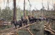
Inclines

A common element of timber tramway systems were inclines. These took the form of two-railed winch-operated haulages where the load had to ascend the incline, or three-railed gravity-operated lowering-gears where the load had to descend the incline.

While the valuable cast-iron wheels of the latter were
often removed, isolated examples remain intact, and many still retain frames of heavy timbers in which the wheels were originally mounted.

In the map, the red arrows show where the main inclines crossed the O'Shannassy Aqueduct - the concrete bridges still exist and may be inspected along the Aqueduct Trail!

donnabuanginclines2aqueductcrossings.jpg
Inclines crossing the Aqueduct

1945tramwaysmap.jpg
1945 - map of timber tramways in central Victoria

The maps, above, are from an article in the Melbourne Argus, of October 27, 1945, accompanying an article titled "Victorian Timber Tramways Have their Say "

aqueductvictoriawalkingtrackbridge.jpg
2012 - Mt Victoria Walking Track - crossing the Aqueduct

bencairnrdlogs.jpg
c1920 - Incline over Ben Cairn Rd

Contact Bob Padula