The Forests of Warburton - a Pictorial Heritage - 1853 to 2012

1911 to 1915 -The O'Shannassy Aqueduct and Weir

Home
Scope
1853 - Beginnings
1885 to present day - Dee Valley Mills
1889 to 1919 - Mills in the Wesburn and Old Warburton area
1890 - Roads to the Forests
1901 to 1964 - The Warburton Railway
1902 to 1906 - Anderson's Mill
1902 to 1939 - East Warburton and Onwards
1903 to 1907- Robinson's Mill No. 1
1905 to 1949 - Tramways of the Mills
1905 to 1928 - Parbury's Brookfield Mill
1906 - Wondwondah Estate and the Adventist Church
1907 to 1913 - Richards Mill
1907 to 1922 - Robinson's Mill No. 1
1908 to 1922 - Robinson's No 2 Mill (Cement Creek)
1909 to 1916 - Hermon's Mill (La La Estate)
1909 to 1949 - The Warburton Steam Railway
1911 to 1915 -The O'Shannassy Aqueduct and Weir
1915 to 1973 - Brimbonga Seasoning Works - East Warburton
1918 to 1925 - Sunnydale Mill, East Warburton
1919 to 1920 - Slocum and Walker's Mill
1920 - From the Bush to the Bungalow
1922 to 1932 - Enterprise Mill (La La)
1925 - Family Snow Trip to Mt Donna Buang
1932 to 1937 - Horner's Mill
1938 to 2000 - Tuckman's Mills
1950 - Welcome Back to Warburton
The Donna Buang Range
Timeline
Epilogue
Bibliography
The Author's Personal Websites

1915buildingaqueduct.jpg
1915 - Building the Aqueduct

Bridge crossings over the Aqueduct
This is an extract from a map produced in1957 by the Department of Lands and Survey, headed "Mt Donna Buang". It shows the locations of some of the concrete bridges crossing the Aqueduct, which carried logging tramways, depicted by small parallel lines,

bigmapbridgesextract.jpg
Locations of of the Aqueduct bridge crosssings (1957 map)

1925shannassytramcrossing.jpg
Tramway crossing the Aqueduct

The O'Shannassy Aqueduct and Weir

Reference is made in this Study to the O’Shannassy Aqueduct, which was built in the period 1911 to 1915, carrying water from the O’Shannassy Weir to the Surrey Hills reservoir. 

The Aqueduct consists of open channel and underground steel pipes.

It was decommissioned in 1997 and the management track is now an excellent 31 km walking/cycling trail.


The Trail follows the former Aqueduct Maintenance Track, starting at Parrot Rd (Launching Place) and ending at the O'Shannassy Weir (East Warburton),


As the Trail is a step-on, step-off route, these are the sectors:

Parrot Rd to Ewart's Rd 4 km (pipe)
Ewart's Rd to Dee Rd 5.3 km
Dee Rd to Sussex St 4 km
Sussex St to Yuonga Rd 3 km
Yuonga Rd to Cement Creek 6.8 km
Cement Creek to O'Shannassy Weir 7.6 km
 

Many of the logging tramways and inclines intersect the Aqueduct, and concrete bridges were built over it to carry the rails, to allow access from farming properties, and to facilitate original construction activities.

These bridges survive to the present day, and can be inspected along the Aqueduct Trail. Signs on some of these bridges denote the names of the original land-owners or mills.


Serious landslides damaged the Aqueduct in 1925, 1936, 1947 and 1991, and some sections of the open channel were replaced with mild-steel pipe.
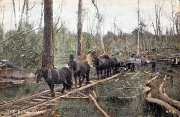
February 1926 - repairing Aqueduct after landslip

ohannassyaqueductdeeslip.jpg
May 2012 - location of 1947 Aqueduct Dee landslip repairs

Contact Bob Padula