foxptbannerlatest.jpg

Home
Design and Operations
Gallery One
Gallery Two
Gallery Three
Gallery Four
After the Closure - Part 1
After the Closure - Part 2
After the Closure - Part 3
After the closure - Part 4
After the Closure - Part 5
After the closure - Part 6
After the closure - Part 7
After the closure - Part 8
After the closure - Part 9
After the closure - Page 10
After the closure - Part 11
History Timeline - 1840s to 1997
History Gallery - 1971 to 1972 (Part 1)
History Gallery - 1971 to 1972 (Part 2)
History Gallery - 1971 to 1972 (Part 3)
Present Day Images Part 1
Present Day Images Part 2
Present Day Images Part 3
NEW! Present Day Images - 2015
Location Maps
Parish Map
Mt Dandenong Tourist Road - history
About the Author, and his Photo Galleries
Pictorial Heritage of Victoria
References, Further Reading and Acknowledgements
,

COPYRIGHT
All rights reserved. No part of this publication may be reproduced, stored in a retrieval system, or transmitted in any form or by any means electronic, mechanical, photocopying or otherwise without the prior written permission of the author.

Creative Commons License
Fox's Point Scenic Railway - Kalorama - Pictorial Heritage by Robert J. Padula, OAM is licensed under a Creative Commons Attribution-NonCommercial-NoDerivatives 4.0 International License.

broadbents1953.jpg
1953 - part of Broadbent's map

foxptextra.jpg
1954 - the Railway! (SLV)

foxptlandvicamended.jpg
Approx alignment of railway, in red, using 2009 Port Phillip Region Aerial Photography Map, Landvic

thompsonmap.jpg
2014 - alignment of the railway (John Thompson)

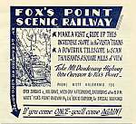
fox06.jpg
From a promotional poster - 1960

historicdandenongslogo.jpg


SYNOPSIS
An almost forgotten part of the Dandenong Ranges history in Melbourne's outer east is the Scenic Funicular Railway, which was a popular tourist attraction between 1953 and 1961, located on the north face of Mt Dandenong.

Known as the "Vista Trains", it was about 3 km from the township of Montrose, on timbered bushland, It was located in the vicinity of what is now 1106
Mt Dandenong Tourist Rd, within what was to become the Dandenong Ranges National Park, at "Windy Corner", near the intersection of Inverness Rd.

This Project looks at the "Vista Trains" - a Special Chapter showing historical images of the early days of the Mt Dandenong Tourist Rd is included.
 
The Project uses the terms "Railway" and "Tramway", which mean the same thing!

See the full story!


ABOUT THIS PROJECT
This work is a free on-line dissertation, containing 30 chapters, which brings together many heritage images, descriptive text, location maps and drawings, about the long-forgotten Scenic Railway, Kalorama.
 
Navigation
Each major theme in this Study has its own Chapter, accessed from the Navigation Bar on each Page.

Images
All images are thumbnailed. Cl
icking any image will produce a full-sized display in a new browser window.

Search Engine
There is a Search Engine on this page! This will take the reader to a new window displaying the locations in this site for the search query.

System Requirements
This website requires the following applications to be installed for full functionality: Adobe Flash Player (or similar), Javascript, and Windows Media Player (or similar). The site is optimised for Internet Explorer 9 - the use of other browsers may not yield satisfactory results. Cookies must be enabled. Font sizes may be changed by the user to suit individual viewing preferences.

Sources
Many images are out-of-copyright and sourced to publicly available sites on the Internet - accreditation is not required, but is given where considered appropriate.. A listing of principal research sources used may be found in References and Acknowledgements
. The Study is listed under a Creative Commons License. The author advises that it has been impossible to verify or validate some information, due to the passage of time, but every attempt has been made to verify operational dates and technical specifications of the Railway, where possible.

Images
Unless otherwise indicated, all images are those taken by the author, from his visits to the location
.

Google Maps Streetmap Images.
Some Streetmap  images are displayed in the Project. Some of these are up to four years old, even though downloaded in March 2014, and should not be considered as real-time representations of the places shown!

Advertising
Targeted adverts are displayed on the site via AdSense.

Publication History
Version 1 - January 2014

Version 2 - March 2014 (inclusion of text and images describing the dismantling and recovery in 1965)

Version 3 - December 2014 (inclusion of text and images about land usage between 1849 and 1972)

Version 4 - April 2015 (inclusion of text and images showing the site in late February 2015, following clearing operations)

Version 5 - November 2016 - inclusion of additional text

Version 7 - September 2017 - addition of modified Copyright protection notice

Additions or corrections are welcomed from readers. 
  

DONATIONS!
Please consider sending in a small donation to assist in site hosting fees! You may use the PayPal button.


web counter