HISTORY
The land where Greythorn Park currently is situated was owned by the
Maughan family from 1838, when the area was thinly settled and largely bushland.
When electric trams first began reaching the area, most notably the tram to
Burke Road Kew in 1938 (present day route 48), it encouraged further subdivision
of the area. By this time, the area was known as 'Whitethorn', which was later
changed to 'Greythorn' to avoid confusion with Whitehorse Road.
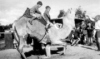
In 1938, with the tram now extended to Balwyn Road, the North Balwyn
Wildlife Sanctuary was opened on the present-day side of the park. Operated by
the Maughan family, the facility contained Australian native animals, and played
host to many American serviceman who were stationed in Melbourne during the
Second World War in the 1940s. The sanctuary closed in 1954, but not before most
of the land was bequeathed to the City of Camberwell for a recreational park in
1951. The remainder of the land was subdivided into 62 blocks, and the legacy of
the sanctuary survives through street names such as 'Wildlife Parade'.
The tennis courts at the Greythorn Tennis Club opened in 1968 and the
scout
hall was constructed in 1976.
LANDSCAPE
The park is located on
top of a large hill, with an elevation of 91.2m
above sea level. The park consists of two main open spaces. The western oval is
used by various sporting clubs over summer and winter, with the eastern oval
being allocated for passive recreation. A sports pavilion is situation between
the two spaces, with a scout hall and tennis club pavilion also situated nearby.
A small artificial creek is located near the centre of the park, next to a
children's playground.