|
|
 |
|
|
|

|
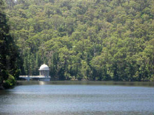
| 2012 - outlet tower |
GENERAL
The Reservoir is 65 km east of
Melbourne, about 225ha, 3km east-north-east of Healesville, comprising the dam wall and associated engineering, the pondage
and the park land and recreation area south of the dam wall.
Wiih its distinctive classically-inspired outlet tower and dam wall, it represents the
first of three major water supply reservoirs constructed by the MMBW during its second major phase of development, in the
1920s and 1930s.
It was officially opened in June 1927.
The dam wall is a distinctive example of early engineering
techniques, with its gravity arch design and Cyclopean rubble concrete construction.
The construction
of the dam wall represented an important advance in the technology of dam-building, utilising a by-cable aerial ropeway and
travelling aerial cableway, the same system later used in the construction of the Silvan dam in 1927-31.
The reservoir,
and the associated reservoir park, together comprise one of the most popular and enduring tourist destinations for day trips
from Melbourne, providing generations of visitors with views of the natural forest catchment surrounding the reservoir and
the landscaped gardens within the park.
With the completion of the dam in June 1927, the aqueduct sides were raised
to increase its capacity to 50 million gallons per day (227 megalitres per day) and the inverted siphons were duplicated to
provide for greater flow
With the Maroondah and O'Shannassy Dams completed by 1927, the systems were able to be used
to supplement the Yan Yean system in the prolonged drought in the mid-1920s.
The Maroondah Reservoir, with its distinctive
Classically-inspired outlet tower and dam wall, represents the first of three major water supply reservoirs constructed by
the MMBW during its second major phase of development during the 1920s and 1930s.
The reservoir,
and the associated reservoir park, together comprise one of the most popular and enduring tourist destinations.
|
|

|
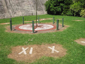
| 2012 - the Floral Clock at base of reservoir |
PERIMETER FENCE
By 1932, the Board had
completed erecting the final 200 chains of perimeter fence to enclose the reservoir margin. Although there is no further documentation
about the perimeter fence, the Maroondah Reservoir and Catchment comprised one of the most publicly accessible watershed areas,
and the fence was established as a deterrent to interference with the water supply whilst allowing the public to continue
to use the Fernshawe Road (later called Maroondah Highway) and the various walking tracks in the Catchment,
The Board
also metalled the park roadway and parking areas, laid out pathways, erected two public shelters, a building to supply hot
water for visitors, and undertook extensive landscaping of the Reservoir Park with 4,500 Pinus insignus, 968 poplars, cedar
and Oregon, 320 willows and 79 shrubs
RAILWAY
In 1928, a proposal was advanced
for building a tourist railway line from Healesville to the Reservoir, but this was rejected by the Government.
ARCHITECTURE
The Maroondah dam consists
of a gravity arch, Cyclopean rubble concrete wall, extending to a total length of 946 feet along the top. It is 135 feet height
at the highest point, and a maximum thickness of 101 feet at the base. Compared with the Board's other storage reservoirs,
the Maroondah dam is an unusually elongated structure.
The dam has a distinctive concrete walled walkway along the
top of the curved dam wall, featuring large concrete pillars and sections with oblong holes. Circular cuts in the walkway
floor represent cores cut vertically into the dam wall in 1989 in order to sink steel tensioning cables into the rock base
of the wall. This was part of remedial work undertaken at that time, including the enlargement of the spillway. A section
of one of the cores removed from the wall is located near the walkway entrance, and illustrates some of the smaller "plums"
(large pieces of rock) that were set into the concrete during the dam's construction. An inspection tunnel traverses the interior
of the dam wall for most of its length, and vents (added later) indicate the extent of the tunnel near the top of the wall.
Two recently restored brass plaques mounted on the entrance pillars to the walkway commemorate
the construction of the dam between 1920 and 1927. The walkway along the top of the dam wall leads to a new bridge over the
concrete spillway, expanded to twice its original width in 1989 to allow for peak flood conditions.
The natural rock
wall on the eastern side of the spillway remains in its original condition, while the natural rock section of the lower end
of the spillway (visible from the Reservoir Park below the wall) has also been widened since first constructed. The original
section of rock is distinguishable because it forms a U-shape, unlike the recently-cut straight section of rock.
A
plaque and time capsule were set in the base of the wall in 1991 during the centenary celebrations for the opening of the
Watts River Diversion Weir and Aqueduct system. It is to be opened in 2041.
The equally distinctive
outlet tower is located in the reservoir near its northern perimeter, visible from the dam wall. It is a circular domed structure
in a Classical style featuring columns with capitals, and set on a circular concrete base. An arched bridge connects the tower
with the land, and an entrance arch at the entrance to the bridge continues the Classical theme.
The reservoir receives
inflow from a total catchment area of 14,680 ha, plus the Grace Burn Creek diversion weir via a channel to Lindupp's Basin
and siphon.
A natural manna gum forest covering about 0.5 ha is located on the northern bank
of the Watts River, near the base of the spillway.
|
|
ORIGINAL FEATURES REMAIN
The
features remaining from the 1920s, including the two valve houses, caretaker's house, toilet buildings, entrance pillars and
gates, and plantings of exotic trees, are of particular interest in the way they demonstrate the way the Board maintained
the functions of water supply whilst developing the park as a tourist mecca for healthy outdoor activities.
The caretaker's house and older toilet buildings demonstrate the development
of staff and visitor facilities throughout the catchment in the late 1920s. The later features added in the 1940s, including
the rotundas, rose steps, pathways, compensation channel and sundial, demonstrate the continuing popularity of the park for
visitors, and the distinctive role played by the Board's reservoir parks in providing recreational areas for public use.
The Maroondah Reservoir, with its distinctive Classically-inspired outlet tower and dam wall, represents the first
of three major water supply reservoirs constructed by the MMBW during its second major phase of development during the 1920s
and 1930s.
Significant features that have been
retained from this early period of the Park's development are summarised as follows:
Two concrete domed valve houses. These were among the earliest structures to be built in the
park, and controlled the flow of water from the reservoir into the Maroondah Aqueduct, the water passing through "Echo Tunnel"
and entering the aqueduct near the Sawpit Weir. The hydraulically operated valves (similar to those in the Silvan outlet tower)
have since been replaced by a new valve system housed on the opposite side of the Watts River.
Caretakers house. A red brick structure separated from the park by a fence, and with its own
garden setting. This was one of two constructed in 1928-29, in the same period as modern sanitary conveniences were constructed
in the park, and at Condon's Gully, Grace Burn Weir, Donnelly's Weir and Fernshaw.
Two
red brick toilet buildings. Constructed in 1929-30, and similar in design and materials as those at Condon's
Gully, Grace Burn Weir and Donnelly's Weir. The Fernshaw toilets have since been demolished. The park toilets were once surrounded
by high hedges.
|
|
 |
|
|
|
|
|
 |

