|

The Mont Albert District - Pictorial Heritage - 1830 to 2013 by Robert J. Padula OAM
is licensed under a Creative Commons Attribution-NonCommercial-NoDerivs
3.0 Unported License.
Based on a work at https://bpadula.tripod.com/montalbert.
|
|
|
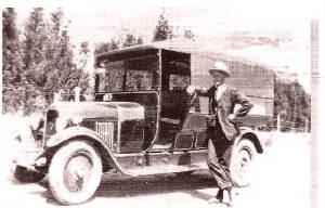
| 1925 - minibus at Box Hill |
Synopis
This is a Pictorial Research
Project, which examines the history, development, and evolution of the leafy suburb of Mont Albert,12 km east of central Melbourne,
from its beginnings in 1830 until the present.
Much of the content has been derived from the author's first-hand knowledge of Mont Albert, which
has been his home since 1959, supported by interviews with long-time residents.
The present day surburb of Mont Albert did not really begin until the early
1890s - prior to then, it was part of Surrey Hills and Box Hill, and relevant background information about those suburbs
is included, as well as content about adjoining present-day Mont Albert North.
Add your content here
|
|
BOX HILL AND NEARBY SUBURBS - NOSTALGIA - LOCAL AND FAMILY HISTORY This is a Facebook Group, administered by the author (Bob Padula). Anyone
may join who has a Facebook account! It's at
|
|
|
| 1937 - aerial view showing part of Mont Albert and Broughton Brick Works (centre) |
|
|
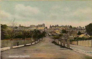
| 1908 - Union Rd looking north from near Canterbury Rd |
|
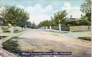
| 1907 - Albany Crescent |
|
|
|
|
|
Click the author's Facebook profile pic (below) to go to his Facebook service

Create Your Badge
Add your content here
|
About the Author
This
Heritage Study is a work by Bob Padula, OAM, of Mont Albert, Victoria, Australia.
Bob is a Chartered
Professional Commiunications Engineer, holding the rank of Life Member, Institution of Engineers (Austraiia), providing specialized
technical consultancy services and authorship in the field of international high frequency broadcasting
He also has a keen interest in
hiking, bushwalking, coastal walking, and light railway history, and exploring the mountains around Melbourne, activities
which support his involvement in amateur photography.
Bob is a member of the Australian Light Railway Research Society, Bushwalking Victoria, and the Great Dividing Trail Association.
His affinity for research
into the history of the Forests, Timber Mills, and Water Supply Systems to the east of Melbourne is reflected in his authorship
of several popular on-line Heritage Projects about those themes.
His on-line autobiography
may be viewed at "Looking Back - 1939 to 2011"
The author also maintains several free Photo Websites
dedicated to his travels.
Links and descriptions are at The Author's Personal
Websites
His latest on-line Engineering Research Study
is "The History of
Short wave Broadcasting in Australia"
|
|
|
| 1925 - orchard in Mont Albert |
About this Project
This work is a free on-line dissertation, containing 35 chapters, which brings together many heritage images, descriptive
text, sound, video, location maps and drawings.
Navigation
Each major theme in this Study has its own Chapter, accessed from the Navigation Bar on each Page. The Chapters
are arranged in chronological sequence, where appropriate
Images
All images are thumbnailed. Clicking any image will produce a full-sized display in a new browser
window.
Search Engine
There is a Search Engine at the top of this page! This will take
the reader to a new window displaying the locations in this site for the search query.
System
Requirements
This website requires the following applications to be installed for full functionality:
Adobe Flash Player (or similar), Javascript, and Windows Media Player (or similar). The site is optimised for Internet Explorer
9 - the use of other browsers may not yield satisfactory results. Cookies must be enabled. Font sizes may be changed by the
user to suit individual viewing preferences.
Sources
Many images are out-of-copyright and sourced to publicly available sites on the
Internet - accreditation is not required or given. A listing of principal research sources used may be found in References
and Acknowledgements. The Study is listed under a Creative Commons License.
Images
Unless
otherwise indicated, all images tagged "2011, 2012" or "2013" are those taken by the author, from his visits to the locations
described in this Project Advertising
Targeted adverts are
displayed on the site via AdSense.
Publication
This Project Study is published in June 2013 - additions will
be made from time to time
Add your content here
|
|