|
|
 |
|
|
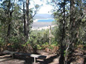
| View from Doctor's Creek Track Lookout - Upper Yarra Dam |
Doctor's Creek Track - Upper Yarra Reservoir
Region. (100 km east). Access: Warburton, Upper Yarra Reservoir Park.
Signed track starts at north end of main picnic ground. Track follows Doctor's Creek, then ascends to the Reservoir Lookout.
Continut to Summit, reaching a clearing and former helipad. Return to start. Excellent
views across the Reservoir and Victorian Alps. The Track was built in the 1930s for
logging, and then used in the 1950s for the Reservoir construction (which opened in 1957). Warning:
the Track from the Lookout to the Summit is very steep! (6 km, 2 hrs, March 2007)
Map | Photos
Backstairs
Track. (90 km E). Access: Warburton Highway, turn left opposite Warburton Golf Club under old railway
bridge to car park. Follow boardwalk to Dolly Grey Park. Continue up steep Backstairs track, reaching Old Warburton Rd. Return
to car park. Passes through scenic Dolly Grey Park, and follows the Backstairs Creek Valley
through tall timber. (5 km, 1.5 hrs, May 2008).
Photos | Map - see Melways or Rooftops Series: Yarra Valley-west Gippsland
Britannia Creek Falls - Wesburn. (80 km E). Warburton
Highway, Wesburn, Britannia Creek Rd, to small car park at entrance to Britannia Creek Camping Park. Follow Edggood Way to
Lower Falls and return. Mountain Ash forest, Britannia Creek, Falls.
Note: This track continues to the Upper Falls, which may alternatively be reached via the rough 2WD Britannia Creek Rd. The
Track may be impassable after heavy rain, due to huge mud slides and fallen trees.(3 km, 1 hr, August 2008)
Photos | Map - see Melways or Rooftops Series: Yarra Valley-west Gippsland
Mt Little Joe Summit Track. (90 km E). Warburton
Highway, Wesburn, to small car park opposite gated fire access track. Ascend very steep track to summit and return. Good views across Upper Yarra Valley. (4 km, 2 hrs, June 2005)
Photos | Map - Melways or Rooftops Series: Yarra Valley-west Gippsland
Reid's Mill via Big
Bertha Track. (80 km E). Warburton Highway, Yarra Junction, Powelltown, to small car park at signed
entrance to Track opposite DSE office. Follow track to site of old mill and return. Walk uses steep Big Bertha track some
of the way. Tall forest, fern gullies - track follows alignment of old timber tramway. (6 km, 2 hrs, February 2008).
Photos | Map - Rooftops Series: Yarra Valley-west Gippsland
Reid's Mill Tramway Track.
(80 km east). Warburton Highway, Yarra Junction, Powelltown, to small car park at signed entrance to Track about 500
m east of the town. Follow track to site of old mill and return, a few artifacts remain. Tall
forest, fern gullies - track follows alignment of old timber tramway. The sawmill operated from 1920 to 1930. (4 km, 1.5 hrs, March 2008). Note: this
walk cam be combined with the Reid's Mill Track as a loop, returning via the Big Bertha Track - see previous walk).
Photos | Map - Rooftops Series: Yarra Valley-west Gippsland
La La Falls. (90 km E). Warburton,
La La Falls Rd, to small car park. Ascend track to Falls (some steep/rocky sections) and return. Beautiful
tall forest, ferns, good view of falls. (3 km, 1 hr, January 2009).
Photos | Map - Rooftops Series: Yarra Valley West Gippsland Adventure Map
Yankee Jim's (Old Warburton) - Valley Walk. (90 km
E). Warburton Highway, Old Warburton Rd, to small car park adjacent to colored sign "Old Warburton - a Peaceful Valley".
Pass around locked gate and on to Silvan Yarra Conduit Track. Follow track to a high point and return. (Underground pipeline
passes through tunnel in Mt Little Joe). Track continues downwards to the western gate at Wesburn Reserve. Fern gullies, ferns, creek, valley, views across Yarra Valley. Yankee Jim's was the original
name of the settlement of Old Warburton in the gold rush era. No relics remain - old buildings destroyed by bushfires in 1926.
(2 km, 45 mins, Sep 2007)
Photos | Map - Melways or Rooftops Series: Yarra Valley West Gippsland Adventure Map
Richard's Tramline Track. (100 km E). Warburton,
Warburton-Wood's Pt Rd, Big Pat's Creek Rd, Burn Rd, to small car park. Follow signed Richard's Tramline Track to its end,
at Mississippi Rd and return. Excellent forest, former logging region, restored tramline display,
Richard's Railway Curves (built in the 1920's), interpretative signs. (6 km, 2 hrs, October 2005).
Photos | Map - Rooftops: Yarra Valley - West Gippsland
Ada Tree. (120 km
E). Warburton, Warburton-Wood's Pt Rd, Braham Rd, Big Creek Rd, to Ada Tree picnic area. Follow walking track (muddy) to
Ada Tree and return. Magnificent tall forest, fern gullies, creeks, boardwalks, bridges, interpretative
signs, Ada Tree. (6 km, 1.5 hrs, October 2005).
Photos | Map - Rooftops: Yarra Valley - West Gippsland
Spion Kopje Summit Walk.
(100 km E). Warburton Highway, Yarra Junction, Powelltown, Limberlost Rd, to small car park at Spion Kopje Track.
Ascend steep track (not signed) through forest. Final section is a scramble up a large rock-face. Good
views across Yarra Ranges, Bunyip State Forest and Yarra State Forest. (2 km, 1 hr, October
2005)
Photos | Map - Rooftops: Yarra Valley - West Gippsland
Seven Acre Rock. (100
km E). Warburton Highway, Yarra Junction, Powelltown, Turner Rd, Learmonth Rd, Bunyip Rd, to small car park at picnic
ground opposite track entrance. Follow track (rocky in parts) to summit and return. Excellent
views across Bunyip State Forest. (2 km, 1 hr, January 2008).
Photos | Map - Rooftops: Yarra Valley - West Gippsland
Walk into History - Starling's Gap Sector.
(100 km E). Warburton Highway, Yarra Junction, Noojee Rd, Powelltown, Big Creek Rd, to Starling's Gap Picnic/camping
area. Follow signed track along Ada River to overgrown site of Ada Mill, about 2 km, return to car. Beware of snakes!
This tk is part of the longer Walk into History Trail. Tall timber, ferns, creek crossing,
through forrmer sawmilling region. (4 km, 1.5 hrs, April 2008)
Photos | Map - Rooftops: Yarra Valley - West Gippsland
Walk into History - Big Creek Basin Sector
(100 km E). Warburton Highway, Yarra Junction, Noojee Rd, Powelltown, to Big Creek Basin Rd. Leave car at marker,
follow track westerly for about 2 km and return. Tall forest, fern gullies, track follows
alignment of old timber tramway, adjacent to La Trobe River. (4 km, 1.5 hrs, April 2008)
Photos | Map - Rooftops: Yarra Valley - West Gippsland
Walk into History - Nayook West Sector
(100 km E). Warburton Highway, Yarra Junction, Noojee Rd, Powelltown, to Big Creek Rd junction. Follow track
easterly signed "Nayook West" past site of former timber mill settlement of Nayook West, reaching Fireline Track, then
return. Tall forest, fern gullies, creeks, ghost town site. (4
km, 1.5 hrs, February 2008)
Photos | Map - Rooftops: Yarra Valley - West Gippsland
Walk into History - High Lead Section
(100 km E). Warburton Highway, Yarra Junction, Noojee Rd, Powelltown, to High Lead car park. Locate track marker
on north side of highway, follow track easterly alongside the La Trobe River to a point near Big River Basin Rd,
then return. Tall forest, fern gullies, river, Warning: track passes over many bog-holes,
beware of snakes. (4 km, 1.5 hrs, February 2008)
Photos | Map - Rooftops: Yarra Valley - West Gippsland
Walk into History - Big Pat's Creek
Sector. (100 km E). Warburton Highway, Warburton, Woods Pt Rd, Big Pat's Creek Rd, picnic ground
at Big Pat's Ck. Follow signed Track to Ezard Mill site and return. Superb tall timber forest,
lush ferns, remains of old timber tramway and sawdust heaps at old mill. (6 km, 2 hrs, August 2008).
Note: This is the northern sector of the full walk, which may be followed to
Starling Gap.
Photos | Map - Rooftops Series: Yarra Valley West Gippsland Adventure Map
|
|
|
|
Distances to the start of walks, from Melbourne, are in brackets against
their descriptions
|
|
|
|

