|
|
 |
|
|
|
|
|
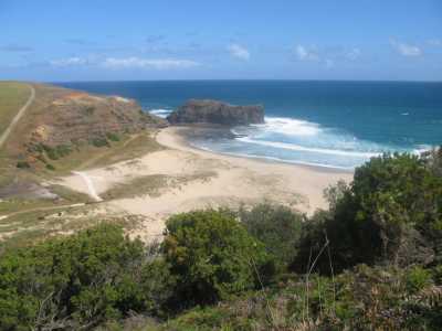
| Bushranger Bay - Westernport Coast |
THESE LINKS WILL TAKE YOU TO THE WALKS IN THE PRINCIPAL NATIONAL PARKS, STATE
FORESTS, RESERVES, STATE PARKS AND SANCTUARIES IN THE SOUTHERN REGION
WALKS TO OTHER PLACES IN THE SOUTHERN REGION
Balnarring Wetlands. (65 km SE). Frankston-Flinders
Rd, turn off at Balnarring village, to small car park next to the Primary School, at signed Wetlands Reserve. Go through
gate, follow the main walking track around the billabongs and Lake. Boardwalks, bird
hide, bridges, bushland, wetlands, interpretative signs. (One hr, 3 km, September 2009).
Warragine Park - Bittern. (60 km SE). Westernport
Highway, Hastings, to small car park and information board at Salmon St, the northern gated access point to the Bittern Coastal
Wetlands Track. This is a shared walking/cycling track, most of it on a raised boardwalk. Follow the track to its end at Jack's
Beach and return. Track is in the coastal wetlands section of the Park - adjacent sections are the Woodlands and Creeklands.
Interpretative signs, two good lookouts, birdlife. mangroves, salt marshes, wetlands.
(8 km return, 2 hrs, Oct 2008).
Photos | Map - Melways
Warringine Park Creeklands - Bittern. (60 km SE). Westernport Highway, Hastings, to small car park at the Park Office, just south
of Hastings. Follow 4WD track to gated entrance to the walking track. This ends at Henderson's Rd. Return to car. Track follows the Warringine Creek, with boardwalks, bridges, interpretative signs, and viewing
platforms overlooking the billabong. (4 km, 1 hr, December 2008)
Photos | Map - Melways
Woolley's Beach Reserve Walk - Crib Point. (60 km SE). Westernport
Highway, Hastings, Stony Pt Rd, Woolley's Rd, signed picnic ground at Crib Pt Jetty. Follow marked walking track south, reaching
the Esplanade. Return to boat ramp, follow beach to the start. Green bushland, ferns, sandy, good views to French island, inspect the remains of Bill Woolley's underground
fish coolstore, built 1903. The decommissioned submarine HMAS Otama is
adjacent to the jetty. (5 km, 1.5 hrs, April 2007)
Shoreham-Point Leo Beachwalk. (85 km S). This is a Beachwalk,
starting and finishing at the Shoreham Beach carpark, turnoff at the main Flinders Rd. The walk is mainly on the beach, best done at low tide, to avoid getting trapped near the cliffs. (9 km, two hours, January 2009)
Photo Album | Map - Melways Balnarring to Somers Beachwalk. (80 km S). Access: from the Hastings-Dromana Rd. then along Balnarring Beach Rd,
to car park at the beach reserve. Follow the beach to the east, passing the Coolart Homestead, reaching Somers Beach, then
return. Best done at low tide, to explore the exensive rock pools which become exposed. Good
swimming, and nice views across Westernport Bay, Coolart Wetlands.
(4 km, 1 hr, Mar 2009)
Photos | Map - Melways
Balnarring Coastal Walk. (80
km S). Access: from the Hastings-Dromana Rd. then along Balnarring Beach Rd, to car park at the beach reserve.
Follow the beach to the west towards Pt Leo, then return. Best done at low tide, to explore the exensive rock pools which
become exposed. Good swimming, and nice views across Westernport
Bay. (4 km, 1 hr, Mar 2009
Photos | Map - Melways
Merricks to Pt. Leo (85 km S). This is a beachwalk. Access:
from the Hastings-Dromana Rd. starting and finishing at the Merricks Beach Car Park. Follow the beach to the west, reaching
Point Leo, then return. Best done at low tide, to explore the exensive rock pool which become exposed.
Good views across Westernport Bay - some interesting lush rainforest
adjoins the beach. (6 km, 2 hrs, January 2007).
Point Leo Beachwalk (85 km S). Access: from the Hastings-Dromana
Rd, then along the Pt leo Rd, to the Pt Leo car park/picnic area. Follow the beach to the west, reaching the large reef, then
return and explore the eastern Reef. Best done at low tide, to explore the exensive rock pools which become exposed. Good views across Westernport Bay. (4
km, 1 hr, Feb 2009)
Photos | Map - Melways
Merricks to Balranning (85 km south). This is a beachwalk. Access:
from the Hastings-Dromana Rd. starting and finishing at the Merricks Beach Car Park. Follow the beach to the east, reaching
Balnarring Beach, then return. Best done at low tide, to explore the exensive rock pools which
become exposed. (4 km, 1 hr, Feb 2009)
Photos | Map - Melways
Merricks-Red Hill Trail (Western Sector). (85 km S). Moorooduc Highway,
Red Hill, to picnic ground/car park adjacent to town centre, on Pt Leo Rd. Follow rail-trail to the View Point, and return.
Excellent views across Westernport Bay, wineries, bushland, pine trees, hills.
(7 km, 2 hrs, December 2007). See also the eastern sector walk! The trail can be undertaken as a single long walk
of 15 km return from either end. Photos | Map - Vicroads or Melways
Merricks-Red Hill Trail (Eastern Sector).
(85 km S). Westernport Highway, Hastings, Merricks, to small car park at Merricks Station Reserve. Follow foot-track
past Reserve, reaching Equestrian/Walking Trail. Follow trail uphill, stony in sections, to a turnabout point about
2 km from start and return. Trail follows the alignment of the fomer Merricks to Red Hill railway, which operated from 1921
until its closure in 1953. Vineyards, wineries, farmland, views to Westernport Bay. (4
km, 1 hr, December 2007)Photos | Map - Vicroads or Melways Flinders Coastal Walk. (85 km S). Access:
Hastings-Dromana Rd, to Flinders foreshore carpark. Ascend the interesting Cable Station Walkway
and return to the carpark, go out to the end of the long Jetty and return.. Proceed easterly towards Shoreham along the
beach to about 2 km from start. This is the turnaround point, which links with my walk titled "Shoreham
Beach Trail". Best done at low tide to avoid getting stranded! (5 km, 1.5 hrs, January 2007)
Somers-Sandy Point Coastal Walk (85 km S). Access: Hastings-Dromana
Rd, turn left at Somers Rd, walk starts at the carpark opposite the general store. Descend to the beach, follow the
beach to Sandy Point, reaching the HMAS Cerberus "entry prohibited" fence line. Return to a stairway,
this is the eastern end of the Koala Walk. Proceed up and along this walk, to its western end near the Yacht Club. Return
to carpark via the upper level Sheoak Walk. Good views across Westernport Bay.
(6 km, 2 hrs, May 2009).
Somers Coastal Walk (85 km S). Frankston-Flinders Rd,
Balnarring, Sandy Pt Rd, to Somers village. Walk starts at the carpark opposite the general store. Descend to the beach,
follow signed Koala Walk east, reaching the beach, continue along the beach for about 1 km. Return along Koala Walk to the
west, then up a staircase to a seat and view point, reaching Sheoak Walk, and back to carpark. Bushland
environment and beach, g ood views across Westernport Bay.
(4 km, 1 hr, Mar 2009).Photos | Map - Vicroads or Melways Shoreham Beach Trail.
(85 km S). A Beachwalk, best done at low tide. Start and finish at Shoreham Beach, reached from the turn-off on the
main Flinders Rd. Proceed westerly towards Flinders, passing cliffs and coastal bushland to a headland about 2 km from
start. This is the turnaround point. Good coastal views. This walk links
with my "Flinders Coastal Walk". (4 km, 1 hr, December 2006)
Royal Botanical Gardens Walk - Cranbourne. (65 km SE). Access:
South Gippsland Highway, Cranbourne, Bullarto Rd, to Stringybark Picnic Ground. Follow signed trail to trig Poinht Lookout,
return via Perched Swamp, Wetlands and Manna Gums trails. Excellent views from lookout across
the park, to Westernport Bay, South Gippsland, Mt. Macedon, Dandenong Ranges. Walk passes through wetlands, woodlands, heath,
forest, and around the lake. watch out for snakes and bandicoots! Visit the nearby Australia
Garden (admission fee) if time permits. (6 km, 1.5 hrs, March 2007)
Photos | Map
Devilbend Reservoir Reserve - Tuerong. (55 ik SE). Frankston, Mornington
Peninsula Freeway, Old Moorooduc Rd, Tuerong Rd, to large picnic ground at Reservoir. Explore the Reserve! Good views of the
Reservoir. The Reservoir is now used as a backup, and the entire area, 1025 hectares,
is to become a National Park. (1 km, 30 mins, April 2007)
Langwarrin Fauna and Flora Reserve. (30 km S). Access: Westernport
Highway, Cranbourne-Frankston Rd, McClelland Rd, to car park. Follow signed Reservoir Track, Long Crescent North, Centre Break,
and return to start. The reserve was once a military facility. Interesting heathland, woodland
and reservoir. (4 km, 1 hr, April 2007).
Photos | MapCannon's Creek Coastal Park. (65 km SE). Westernport Highway,
Baxter-Tooradin Rd, Cannon's Creek Rd, to picnic ground at Cannon's Creek International Conservation Zone. Follow lower-level
walking track through mangroves and crab colonies to western jetty, continue to tip of peninsula, passing large open bushland
reserve. Return via upper level walking track through bushland, mangroves. Good views across
Rutherford Inlet. (3 km, 1 hr, Feb 20-09).
Photos | Map - see Melways Warneet Coastal Park. (65 km SE). Westernport
Highway, Baxter-Tooradin Rd, Warneet Rd, to picnic ground at Warneet Coastal Village. Explore the Beauty Walking Track, the
Mangroves Walking Track, and the Warneet Coastal Reserve Tracks. Spectacular
scenery and mangroves at the Rutherford Inlet. (4 km, 1 hr, April 2009)
Photos | Map - see Melways Coolart Wetlands and Homestead - Somers. (65 km
SE). Moorooduc Highway, Coolart Rd, Sandy Point Rd, Somers Rd, to car park and visitor centre. Follow signed Woodland
Walk, cross footbridge over Merricks Creek to Foreshore Reserve, then back to Woodland Walk, continue along Loop Tracks 4,
3, 2, and 1 to Lagoon, inspect Homestead, return to start. Unusual wetlands, woodlands,
beauitiful beach, historical features. (4 km, 1.5 hrs, March 2006)
Photos | MapChurchill Island Park (120 km SE). South Gippsland Highway,
Bass Highway, Phillip Island Rd, Churchill Island Rd, to car park at Visitor Centre. Follow Circuit Walk and return. Excellent coastal views, remnant woodland, historic working farm, homestead, gardens. (4 km,
1.5 hr, May 2009).
Photos | Map - Melways
Briar's Historic Park - Mt. Martha. (60 km S). Frankston, Nepean
Highway, to car park/picnic ground near Craigie Rd. Follow signed Koala, Woodland and Wetland Tks. Bushland, forest, wetlands, ferns, fern gullies, dams, Balcombe Ck, bridges, historic homestead, wildlife sanctuary,
boardwalks, snakes, bird hides, lookout, water fowl, birds. An excellent Park! (6 km, 1 hrs, October
2007).
Photos | Map
Mt Martha Park. ( 60 km S). Nepean Highway, Forest Drive, to main
car park at Conifer's Picnic ground. Follow signed Calder Track to Summit and Lookout, return via Nature Track.
Summit is 163 m. Bushland, views to Arthur's Seat, arboretum, wildlife.
(4 km, 1 hr, October 2007)
Photos | Map - Melways
Balcombe Creek Estuary. (60 km S). Nepean Highway, to small car
park at signed entrance to Estuary Walk, opposite Briar's Historic Park. Follow boardwalk to Esplanade and return.
Wetlands, birdlife, bushland, historical features, Balcombe Creek. (4
km, 1 hr, October 2007).Photos | Map - Melways
George Bass Coastal Walk - San Remo Section (100 km S). South
Gippsland Highway, Bass Highway, Phillip Island Tourist Rd, turn off into Punchbowl Rd about 3 km east of San Remo, to small
car park at end. This is the western end of the 7 km walk which terninates at Kilcunda. Follow the signed trail to the
beautful secluded beach at Half Moon Bay and return. Spectacular views of the coast, following
the clifftops. Some sections are steep. The full walk of 14 km return to Kilcunda will require about
5 hrs. (7 km return, 2 hrs, Jan 2009).
Photos | Map - See Parks Victoria George Bass Coastal Walk - Kilcunda Section (120
km S). South Gippsland Highway, Bass Highway, Kilcunda, turn off to car park at Shelly Beach. Follow signed walk to a
viewpoint overlooking Half Moon Bay and return. Spectacular views of the coast, following
the clifftops. Some sections are steep. The full walk of 14 km return to Punchbowl will require about
5 hrs. (7 km, 2 hrs, March 2009) Photos | Map - See Parks Victoria
The Gurdies Bushland Reserve and Lookout. (80 km S). South Gippsland
Highway, Bass Highway, to car park, information kiosk and picnic area at signed entrance to the Reserve. Go
through gate, follow walking track to a junction with a management road, continue left on this road, eventually reaching a
Lookout and small picnic area at the summit. Return via the same route. There are many other signed walking tracks in
the 297 hectare Reserve, leading to and from the Bass Highway. Bushland environment,
former logging area, spectacular views of Western Port from Lookout. There is a change in
altitude from 41m to 126m. (5 km, 1.5 hrs, February 2009)
Photos | Map - See Parks Victoria Cape Woolamai - Pinnacles (Phillip Island).
(120 km SE). South Gippsland Highway, Bass Highway, Phillip Island Tourist Rd, turn off into Woolamai Beach Rd about
5 km east of Cowes to the main car park at end. The unsigned walk starts near the entrance to the car park, ascending
via a sandy track to the cliff top. Pass the Mutton Bird rookeries and continue to the Pinnacles Viewpoint. Return
via the the Magicland Staircase and along the surf beach to the car park. Outstanding coastal
views from the clifftop - the Pinnacles rock formations rise out of the ocean to a height of about 120m.
(4 km, 1.5 hrs, Feb 2009).
Photos | Map - see Parks Victoria
Lang Lang Coastal Walk (80 km S). South Gippsland Highway, Bass
Highway, to turn off along Jetty Lane, to car park and boat launching ramp at foreshore. Follow the beach northerly to
the estuary of the Lang Lang River, then return to the red cliffs (Red Bluff) at the southern end of the foreshore
reserve. Good views to French Island and the Tooradin region - extensive mud flats at low
tide - seabird habitat - quaint historical boatsheds. (6 km, 2 hrs, March 2009)
Photos | Map - see Melways Corinella Walking Tracks (80 km S). South
Gippsland Highway, Bass Highway, to turn off at Corinella Rd to car park and boat launching ramp at foreshore. Leave
car at Settlement Point - follow walking track to observation deck and return. Drive to the historical monument at
the end of Jamison St, then pass through gate and follow signed walking track along cliff top. Drive to nearby Coronet Bay
- return to Bass Highway. Excellent views across the Bay to French Island.
(4 km, 2 hrs, April 2009)Photos | Map - see Melways Flinders - Spring Creek Cove (85 km S). Hastings-Dromana
Rd, to Flinders, then along King St to car park at junction with Golf Links Rd. Deascend signed walking track to Spring Creek
Cove and return. Excellent views across Bass Strait. (2 km, 1 hr, April 2009).
Photos | Map - see Melways Cape Paterson and Bunurong Marine Park (120 km
SE). Bass Highway, Wonthaggi, Cape Paterson, to car park near main camping ground. Follow signed foot track along clifftop,
past Lookout, descend to the Channel rock formation on the reef. Continue on beach past the reef for about 1 km and return
to car. This area is within the Bunurong Marine National Park. Continue along the Inverloch Rd for about 3 km, stopping
at several beach access points, including Undertow Bay, Twin Reefs Bay, and the Oaks Bay.These are well signed and walking
tracks descend to the beach. Excellent coastal views, rockpooling, beachwalking.
(4 km, 2 hrs, April 2009)
Photos | Map - see Melways
The Nobbies Boardwalk - Phillip Island (120 km SE). Bass Highway,
Phillip island Tourist Rd, Back Beach Rd, to Nobbies car park/visitor centre. Follow Boardwalk to Blowhole viewpoint
and return. Spectacular views across Westernport Bay and Bass Strait. (2
km, 1 hr, April 2009).
Photos | Maps - see Melways
Conservation Hill Reserve and Wetlands Trail - Rhyll - Phillip Island.
(120 km SE). Bass Highway, Phillip island Tourist Rd, Coghlan's Rd, Cowes-Rhyll Rd, tio car park at entrance to Reserve.
Follow walking track along boardwalk through the mangrove wetlands to viewpoint at Rhyll Inlet, then a gentle ascent to the Lookout
at summit of Conservation Hill. Return via the same route. Excellent views across Westernport
Bay and the Rhyll Wetlands. (4 km, 1.5 hrs, April 2009).Photos | Maps - see Melways Hastings Foreshore Walk (60 km S). Westernport
Highway, Hastings, to car park next to jetty. Follow signed Foreshore Circuit Trail and return, passing mangroves.
Inspect the Jetty and fresh fish shop! Good views across the boat harbour to Hastings Bight
and Long Point. (2 km, 1 hr, April 2009)Photos | Map - see Melways Rosebud to McCrae Coastal Walk (70 km S.)
This walk starts at the Rosebud Pier and follows the shore to McCrae Beach, akong the Bay Trail. It
passes the historical lighthouse at McCrae - good views across the Bay to Mt. Martha. (4 km, 1 hr,
October 2010)
Photos | Map - see Melways
Dromana to Anthony's Nose Beachwalk (70 km S). Start at the Dromana
Pier, and follow the Bay Trail to Anthony's Nose (cliffs) and return. Nice views to Mt Martha
and across the Bay. (4 km, October 2010, one hour)
Photos | Map - see Melways
|
|
|
|
|
|
|
|
|
|
|
Distances to the start of walks, from Melbourne, are in brackets against
their descriptions
|
|
|
|

