LANGI GHIRAN STATE PARK (160 km)
Hidden
Lagoon (via Link Track). Start is signposted at small
Car Park, on Langi Ghiran (2WD) Track, 2 km from entrance to Park at turn-off 5 km west of Buangor. Track
joins Link Track, rough and steep (old jeep route) for first 1 km, relatively flat on Saddle between Mts Gorrrin
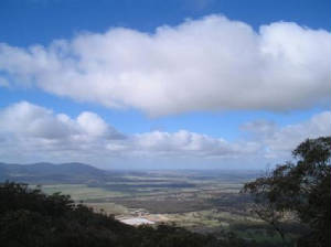
and Langi Ghiran. Excellent views to the south, west, and east. Track then joins Hidden Lagoon Walking Track, then
1.5 km to Lagoon. Highest elevation reached 645 m. (6.5 km return - two hours - June 2006)
Hidden Lagoon (via Hidden Lagoon Walking Track). Start at junction
of Colonial and Bank Roads, eastern entry point to Park. Signposted Colonial Rd branches off Western Highway. 4WD track
leads to management gate, 500 m from Bank Rd. Walking Track follows management track, steep in parts, along Billy
Billy Creek gully, ending at junction with Link Track on Saddle between Mts. Gorrin and Langiu Ghiran. Track continues
1.5 km to Lagoon. There is no formed walking trail connecting the Lagoon Walking Track with Easter Creek Track. Highest
elevation reached 645 m, start elevation 415 m. Track skirts Mt. Gorrin, passing through unusual forest, past assemblages
of huge granite boulders. (7 km return, 2 hrs, June 2006).
Mt. Langi Ghiran (via Easter Creek Track). Enter Park along
Kartuk Rd, from turn-off 8 km west of Buangor, Western Highway. Start walk at end of Reservoir Road, adjacent to
Reservoir, 2 km past main Car Park/Picnic Area. Gradual ascent initially, then steep section, highest point reached
845 m. Good views from rocky outcrops to east and south. (6 km return - two hours - May 2006)
Lookout Track. Enter Park along Kartuk Rd, from turn-off
8 km west of Buangor, Western Highway. Start walk at end of Reservoir Rd, adjacent to Reservoir, 2 km past main Car Park/Picnic
Area. Signposted. Walk ends at small pumping station, partial views to north, but obscured by tall timber. Gradual
ascent. (3 km return - one hour - April 2006)
Reservoir Walking Track. Enter
Park along Kartuk Rd, from turn-off 8 km west of Buangor, Western Highway. Start walk at Main Car Park/Picnic Area. Easy
ascent past old reservoir. Some good views to the south, partially obscured by trees. (3 km return - one hour - April
2006)
Caves Track. This
is a relatively short easy walk starting at the small car park on Langi Ghiran Track, about 1 km from the Western Highway,
at the western end of the Park. It ascends to the Aboriginal Paintings viewing area at the Caves, at the foot of Mt.
Gorrin. The Caves are of significant historical and cultural significance to the Aboriginal peoples of the area. The Track
passes over old sluices, and there are some nice views looking towards the south. (2 km, 1 hr, July 2006)