|
|
 |
|

|
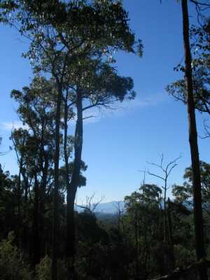
| View from Alpina Track - Mt Evelyn Sector |
West Track - Montrose
Forest Reserve (35 km E). Canterbury Rd, Swansea Rd,
The Boulevard, The Avenue, St. Mark Court. Enter Park at gate, follow West Track steeply to junction with Brown's Tk and return.
Steep and rocky, tall timber in old logging area, views from the summit.
(2 km, 1 hr, July 2007)
Map | Photo Album
Brown's Track Circuit - Montrose Forest Reserve (35
km E). Canterbury Rd, Mt Dandenong Tourist Rd, Inverness Rd, Mountain Crescent, to small car park at gate to unsigned
South East Tk. Ascend this track to junction with Brown's Tk, follow this track to Moore Avenue, then along Mountain Crescent
to start. Some steep sections, tall timber in old logging area, views from the summit.
(5 km, 1.5 hrs, July 2007)
Map | Photo Album
Inverness Track - Montrose Forest Reserve (35 km E).
Canterbury Rd, Mt Dandenong Tourist Rd, Inverness Rd, to gate at unsigned Inverness Tk. Ascend this track to junction with
Brown's Tk and return. Some steep sections, tall timber in old logging area, views from the
summit. (3 km, 1 hr, July 2007)
Map | Photo Album
Wol's Track
(40 km E). Turn off at Inverness Rd, then along Wilkilla Avenue. Start/'finish at gate at
end of Wilkilla Avenue. Go: Hols Track, cross creek (very steep section), turn around at junction of Bridge Track. Return
via lower level track. Rugged forest, tall timber, lush fern gullies, partial views (obscured
by tall trees) across Olinda Creek Valley. (6 km, 2 hrs, June 2006)
Olinda Creek Walking Track - West Sector (40 km E.
Start/finish at signpost at Mt. Evelyn Picnic Ground. Follow track uphill (south), cross stile, then onto wide Pipeline Track
(which terminates at Silvan Reservoir Car Park 6. 8 km to the south). Olinda Creek Walking Track follows Pipeline Track. Turn
west at Alpina Track, go 500 m to reach narrow overgrown foot-track, follow this track for 500 m back to Pipeline Track, return
to Picnic ground. Fern gullies, forest, views of Mt Evelyn timbered area.
Pipeline Track follows the route of the big underground water pipes connecting Silvan and Preston reservoirs. (5 km, 1.5
hrs, June 2006)
Map | Photo Album
Olinda Creek Track - East Sector. (40 km E). Start at car park
opposite Silvan Reservoir entrance. Follow signed Grey Gum Track, then into Olinda Creek Track (also known as Pipeline
Track). Continue on this very wide track to junction with Alpina Track. Return to start. Good
woodland environment. (5 km, 1.5 hrs, May 2006).
Map | Photo Album
Alpina Track Circuit (40 km E). Start at junction of Lilydale-Monbulk Rd and Hunter Rd. Go down
Hunter Rd, cross Olinda Creek at pumping station, reach Pipeline Track (Olinda Creek Walking Track). Go northwest along the
wide Pipeline Track to the Alpina Track turnoff. Ascend steeply
up Alpina Track to junction of Richardson's Track, turn left, descend steeply to junction of Angle Track, then continue
the descent down Alpina Track until Pipeline Track is reached. Return along Pipeline Track to the starting point. The Alpina
Track sector is rated "challenging" by Parks Vic! It passes through interesting forest in the northern sector
of the Park. Excellent views from Richardson's Track across the Yarra Ranges towards Mt. Donna
Buang, Mt. St. Leonards, Ben Cairn, Mt. Juliet. (6 km, 2 hrs, June 2006).
Richardson's Track Circuit (40
km E). The walk starts/finishes at the end of Child's Rd. Follow the foot-track past private property to reach Wallaby
Track, then along Wallaby Track to junction with Richardson's Track and descend steeply to junction with Angle
Track. Ascend steeply up Richardson's Track to reach junction with Alpina Track. Continue past this junction to return to
Wallaby Track, then back to starting point. Excellent views from Richardson's Track across
Yarra Valley. (Moderate, 5 km, 1.5 hrs, June 2006)
Wallaby Track (40 km E). Start/finish at junction of
Track 13 and Olinda Creek Rd.. Follow Track 13, steep in parts, passsing Track 12, and turning left into Track 21 (Wallaby
Track). Proceed to junction with Richardson's Track. Track passes along the ridge top, the highest
point in this part of the Mt Evelyn Section. Tall timber partially blocks views
across the Yarra Valley. Return the same way, but turn left at junction with Track. (4 km, 1.5 hrs,
June 2006)
Forest Explorer Circuit.(40 km E). This walk follows several
tracks. Start: Junction of Track 11 and Stonyford Rd (near the Silvan Reservoir main car park).> Track 11 > Track 12
> Track 24 > return to start. Caution! Track 24 is immensely steep! The walk passes through pleasant tall forest. (4 km, 1.5 hrs, June 2006)
Map | Photo Album
Board Track (40 km E). Lilydale-Monbulk Rd, Stonyford Rd, Silvan
Rd, to gated junction with Track 16. Ascend this Track, reach boundary fence of Silvan Reservoir, continue to junction
with Boundary Rd and return to start. Views across Silvan Reservoir. (4 km,
1 hr, May 2006).
Map | Photo Album
Melba Track. (40 km E). Lilydale-Monbulk Rd, Stonyford
Rd, Silvan Rd, to gated junction with Road 18. Follow Rd 18, Road 13, ascend Melba Track to summit. Return via
steep Tk 24 to start. Tall timber, views across Mt. Evelyn Forest. Option: Continue down Melba Tk to Olinda Ck Tk. This is immensely steep, and
should be avoided in wet weather! (3 km, 1.5 hrs, May 2006)
Map | Photo Album
Circuit Track - Roads 11 and 12. (40 km E). Lilydale-Monbulk
Rd, Stonyford Rd, Silvan Rd, to car park at gated junction with Road 18. Follow Rd 11, Road 12, Road 21, Road 24
(very steep!) , descend to car park. Forest environment. (3 km, 1
hr, June 2006)
Map | Photo Album
Wallaby and Richardson's Tracks. (40 km E). Mt Evelyn, Mt Dandenong
Tourist Rd, Mountainview Rd, to small car park at water tank and gate. Proceed along Wallaby Tk, then Richardson's Tk, to
junction with Angle Tk. Return to car. This walk offers excellent views across the Yarra Valley
to the Ranges. Steep in parts.(3 km, 1 hr, June 2008).
Map | Photo Album
Circuit Track (40 km E).
Lilydale-Monbulk Rd, Stonyford Rd, to car park at gated junction with Road 18. Follow Rd 11, then ascend Road
24 (very steep), then along Road 12, descend to junction with Road 11, return to car park. Forest
environment. (3 km, 1 hr, August 2008)
Map | Photo Album
|
 |
|
|
Distances to the start of walks, from Melbourne, are in brackets against
their descriptions
|
|
|
 |

