|
|
 |
|
|
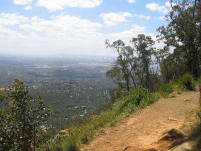
| View from Burke's Lookout - December 2006 |
Singleton Track. (35
km E). Canterbury Rd, Liverpool Rd, Glasgow Rd, to small car park at gate. Follow track to signed Singleton Terrace,
passing Jubilee Tk, Link Tk, Lower View Tk, Marshall Tce, reaching junction with Old Mountain Rd. Return to start. Excellent views to Melbourne, Macedon Ranges, Kinglake Ranges, Mt St. Leonards. Rugged bushland environment,
water points, huge granite outcrops. (8 km, 2 hrs, Sep 2007)
Photo Album | Map
Dandenong Creek Walking Track. (40 km E). Canterbury Rd, Boronia Rd, Forest Rd, Basin-Olinda Rd, to small car park at signed/gated
Dandenong Creek Walking Track. Follow track to its end at junction with Channel Ten Track and backtrack to
start. Superb Mountain Ash forest overlooking lush green fern gullies.
Note: This is a sector of the long Western Slopes Walking Track.(4 km, 1 hr, June 2007)
Photo Album | Map
Doongalla Circuit Walk. (40 km E). Canterbury Rd, Boronia
Rd, Forest Rd, Basin-Olinda Rd, Sheffield Rd, Doongalla Rd, to car park and picnic ground at Doongalla Homestead site. Pass
through gate and follow Stables Tk. Turn left at Bills Tk, Reach Edgar Tk, cross Dandenong Ck at bridge, turn left into Golf
Course Tk, then into Doongalla Rd, continue to car park. Fern gullies and tall timber.
(4 km, 1 hr, June 2008)
Photo Album | Map
Banksia Track. (40 km E). Canterbury Rd, Boronia Rd,
Forest Rd, Basin-Olinda Rd, to small car park at gated Banksia Track. Follow track to its junction with Ridge Track and
return. Very steep in sections - difficult after heavy rain. Track passes through beautiful
Mountain Ash and fern trees, good views towards Sassafras and the farming areas around the Basin.
(4 km, 1 hr, July 2007)
Photo Album | Map
Kyeema Track - Central Sector. (40 km E). Mt.
Dandenong Tourist Rd, Olinda, Ridge Rd, turn-off to small car park signposted Memorial Cairn. Follow former wide track, inspect
Memorial, continue to Trig Tk, then to Ridge Rd, backtrack to car park. Good views towards
Melbourne through forest. This is the central sector of the Track - the southern and northern sectorts
are described separately. (3 km 1 hr, July 2007).
Photo Album | Map
Kyeema Track - Northern Sector. (40 km E). Mt. Dandenong Tourist
Rd, Olinda, to car park at Kalorama "Five Ways". Proceed westerly along un-named walking track - this is the
northern sector of the Kyeema Track. Follow track to Observatory Rd and return. Explore the nearby Mt Dandenong
Arboretum. Note: This is a sector of the long Western Slopes Walking Track. Interesting
forest, good views to west across Melbourne. (4 km,
1.5 hrs, July 2007)
Photo Album | Map
Channel Ten Track.
(30 km E). Canterbury Rd, Boronia Rd, Forest Rd, Basin-Olinda Rd, Sheffield Rd, Doongalla Rd, to car park
and picnic ground at Doongalla Homestead site. Pass through gate and ascend Channel Ten Track, reaching junction with Dandenong
Creek Walking Track. Continue left, reaching junction with Zig Zag Track and backtrack to Homestead. Warning: This Track is very steep, and climbs from 290m to 442m in about 1 km! Excellent forest and fern gullies. Note: This is a sector of the long Western Slopes
Walking Track.(4 km, 1 hr, June 2007)
Photo Album | Map
Zig Zag Track. (35 km E). Mt. Dandenong Tourist Rd, Olinda,
Ridge Rd, turn-off to small car park signposted Memorial Cairn. Follow track south past Burke's Lookout to junction with a
foot track. Descend this steep and rocky track past Channel Ten antenna tower to junction with Zig Zag Track. Continue
down Zig Zag Track to Dacite Track, then backtrack to start. Views through tall timber
to Melbourne and Doongalla. Caution: the foot-track is
very steep and rough and can be impassable after heavy rain. Note: This is a sector of the long Western Slopes Walking
Track. (4 km, 1 hr, June 2007)
Photo Album | Map
Burke's Lookout Walk - Kyeema Track - Southern Sector). (35 km E). This is a short loop walk to a
viewpoint near the top of Mt. Corhanwarrabul, the second highest peak in the Park, at 628 m. Access: Burwood
Highway, Mt. Dandenong Tourist Rd, Olinda, Ridge Rd, turn-off to small car park signposted Memorial Cairn.Inspect the Cairn,
which marks the spot where the Kyeema aircraft crashed in 1939. Follow the upper section of the split-level track south about
500 m to the unsigned lookout. Continue about 500 m to a track junction, then climb to a flat clearing near
the Channel 10 TV facility. Return the same way or take the lower level track from the Lookout. Superb views to Melbourne and to the north and west. Note: This is a sector of the long Western
Slopes Walking Track.(2 km, easy, one hour, July 2007)
Photo Album | Map
Doongalla Homestead Circuit. (30 km E). Canterbury
Rd, Boronia Rd, Forest Rd, Basin-Olinda Rd, Sheffield Rd, Doongalla Rd, to car park and picnic ground at Doongalla Homestead
site. Follow circuit: Stables Track, Bulls Track, Carmellia Track, nature trail. Tall forest,
fern gullies, creeks, bridges. old horseriding paths. (4 km, 1.5 hrs, December 2005).
Photo Album | Map
Ridge Track. (30 km E). Canterbury Rd, Boronia Rd,
Forest Rd, Basin-Olinda Rd, Sheffield Rd, Doongalla Rd, to small car park at main entrance. Follow Ridge Track to its
junction with the Basin-Olinda Rd and return. Tall timber and nice views towards
Sassafras. Warning: This is a steep track and may be impassable
after heavy rain! (3 km, June 2007, 45 mins)
Photo Album | Map
Pavitt Lane Track. (30 km E).
Canterbury Rd, Boronia Rd, Forest Rd, Basin-Olinda Rd, Sheffield Rd, to small car park at junction with gated Pavitt Lane.
Follow Lane to Edgar Track, then to Doongalla Rd and return. Interesting forest environment,
views across open farnland to One Tree Hill. (3 km, 1hr, July 2007) |
Photo Album | Map
Dodds Track. (30 km E). Canterbury Rd, Boronia Rd, Forest Rd, Basin-Olinda Rd, to small car park at junction of gated Range Rd and Dodds Tk.
Descend Dodds Tk, reaching Doongalla Rd and return. Good forest environment, views towards
Mt Dandenong. Note:
This is a horrendously steep and rocky track, and may be impassable after heavy rain! (3 km, 1 hr, July
2007)
Photo Album | Map
School Track. (30 km E). Canterbury Rd, Boronia Rd, Forest
Rd, Basin-Olinda Rd, to small car park at junction of gated Range Rd. Proceed along Range Rd, turn right at School Track (signed
as Horse Trail). Descend to junction with Old Sassafras Coach Rd and return. Track passes
through magnificent fern gullies and forest, views across Doongalla Forest. Note: This is a sector of
the long Western Slopes Walking Track. (4 km, 1.5 hrs, July 2007).
Photo Album | Map
Bradley's Track. (30 km E). Canterbury Rd, Boronia Rd, Forest Rd,
Basin-Olinda Rd, to small car park at junction of gated Bradley's Track. Ascend this Track, reaching Range Rd, and return.
Excellent forest and fern gullies. Note:
This is a horrendously steep and rocky track, and may be impassable after heavy rain! (3 km, 1 hr, July 2007)
Photo Album | Map
Old Sassafras Coach Rd. (30 km E). Canterbury Rd, Boronia
Rd, Forest Rd, Basin-Olinda Rd, Old Coach Rd, to small car park near water tank at junction with Ferndale Rd. Walk up Old
Coach Rd, pass through gate, reaching another gate, then to Sassafras township. Return the same way. Excellent
tall timber, fern gullies, creeks. Note: This is a sector of the long Western Slopes Walking Track.(1.5
hrs, 5 km, July 2007)
Photo Album | Map
Ferndale Rd Track (30 km E). Canterbury Rd, Boronia
Rd, Forest Rd, Mountain Highway, to small car park just past junction with Ferndale Rd. Walk along Ferndale Rd, pass
through a gate, reaching another gate, continue to junction with Old Coach Rd. Note: This is a sector of the long Western
Slopes Walking Track. Pleasant forest scenery. (1 hr, 4
km, July 2007)
Photos | Map
Camelia Track (30 km E). Canterbury Rd, Boronia Rd,
Forest Rd, Basin-Olinda Rd, Sheffield Rd, Doongalla Rd, to car park and picnic ground at Doongalla Stables. Follow signed Carmelia
Tk to junction with Fireline Tk and return. Splendid forest environment, views towards the
west. Sections of this track are muddy after heavy rainy! Steep in parts. (4 km, 1 hr, July 2007)
Photo Album | Map
Edgar Track. (30 km). Canterbury Rd, Boronia
Rd, Forest Rd, Basin-Olinda Rd, Sheffield Rd, to small car park at junction with gated Pavitt Lane. Follow Lane to Edgar Track,
then to junction with Camelia Tk and return. Excellent forest environment, good views on the
high point. The final section of this track is extremely steep and rocky, and slippery in wet weather.
(5 km, 1.5 hrs, July 2007)
Photo Album | Map
Fireline Track. (35 km E). Canterbury
Rd, Mt. Dandenong Tourist Rd, to Fiveways carpark at junction with Old Coach Rd at Kalorama. Walk down Old Mountain
Rd, go through gate, reach junction with Fireline Tk. Follow Fireline Tk to Camelia Tk junction and return. Much of this route is very steep and rocky, through old logging areas, and care is needed after rain.
Excellent views north to the Kinglake and adjacent Ranges. Views towards Melbourne - You Yangs and Macedon Ranges visibible on clear days.
(6 km, 2 hrs, July 2007)
Photo Album | Map
Thompson's Walk. (35 km E). Montrose, Mt Dandenog Tourist
Rd, Child's Rd, Hand's Rd, to small car park next to the fire water tank. Descend gated Thompson's Rd, reaching the western
access gate and return. Interesting views to the north through regrowth forest.
Track is at the 480m level. (2 km, 45 mins, August 2007).
Photo Album | Map
Rowdy's Track. (35 km E). Montrose, Mt Dandenong Tourist
Rd, to car parking zone opposite to gated Rowdy's Track. Extreme care needed in crossing the road, which is very busy with
no shoulders.Ascend this track, reaching Thompson's Rd, and return. Inspect an old hut adjacent to the track. This is an extremely steep track, with a change of altitude of 120m. The top of the track is at 482m.
Good views through the forest towards the Kinglake Ranges. (2 km, 1 hr,
August 2007).
Photo Album | Map
Homestead Tracks. (30 km E). Canterbury Rd, Boronia
Rd, Forest Rd, Basin-Olinda Rd, Sheffield Rd, Doongalla Rd, to car park and picnic ground at Doongalla Stables. Explore the
circuit of Davies Walk, Lawrence Walk, Dobson Walk, Simpson Walk, and Gerraty Walk. Inspect the picturesque Homestead
Picnic Ground. These walks are well-signed. Tall forest, superb gardens, old pony
tracks, magnificient ferns, bridges, views, birdlife. (3 km, 1 hr, November 2007).
Photo Album | Map
Bill's Track Circuit. (30 km E).
Canterbury Rd, Boronia Rd, Forest Rd, Basin-Olinda Rd, Sheffield Rd, Doongalla Rd, to car park and picnic ground at Doongalla
Stables. Follow Stables Tk, then into Bills Tk (very steep), then on to Camelia Tk, and return to car park. Forest environment, creek, fern gullies. (3 km, 1
hr, January 2008)
Photo Album | Map
Pony Trail Circuit. (30 km E). Canterbury Rd, Boronia
Rd, Forest Rd, Basin-Olinda Rd, Sheffield Rd, Doongalla Rd, to car park and picnic ground at Doongalla Stables. Follow Carmelia
Tk, Bills Tk (very steep!), Stables Tk, and return to car park. Forest
environment, creek, fern gullies. (3 km, 1 hr, August 2008)
Photo Album | Map
Singleton Bushland Reserve
and Burke's Lookout. (35 km E). Burwood Highway, Mt. Dandenong Tourist Rd, Olinda, Ridge Rd, turn-off
to small car park signposted Memorial Cairn. Inspect the Cairn, which marks the spot where the Kyeema aircraft crashed in
1939. Follow the upper section of the split-level track south about 500 m to the unsigned lookout. Continue about
500 m to a track junction, then climb to a flat clearing near the TV towers, to a viewpoint near the top of Mt.
Corhanwarrabul, the second highest peak in the Park, at 628 m. Go through gate, continue down Eyre Rd, reaching signed
Singleton Reserve. Follow a foot track through the Reserve, past a small picnic table, reaching a cleared area with good views
gowards the east. Return along Ridge Rd to carpark. Superb views to Melbourne and to the
north and west. (3km, one hour, March 2009)
Photo Album | Map
|
|
|
|
Distances to the start of walks, from Melbourne, are in brackets against
their descriptions
|
|
|
|

