|
|
 |
|
|
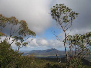
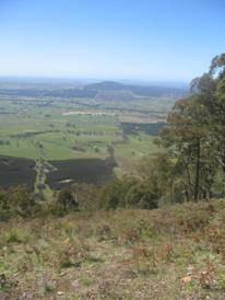
| Mt Langi Ghiran from Ben Nevis |
Ben Nevis Summit Walk (180
km W). Start ands finish at the Chinaman Picnic Ground, 410 m altitude, off
the Buangor-Ben Nevis Rd, turn off at the Western Highway.Follow gated Telephone Track for about 2 km
- this is extremely steep. At top, 700 m altitude, meet Eversley-Sugarloaf Track, follow this track to the right to junction
with 2WD Ben Nevis Rd. Continue along Ben Nevis Rd, passing Shaldars Track and Cowans Track to summit - 880 m altitude.
Return the same route. Superb views at the summit. (9 km return, 2 hours, very steep, July 2006)
|
|
|
|
|
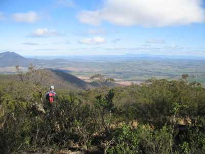
| View from Red Rock |
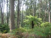
Red Rock Track (180 km W). This is a short walk to the Red
Rock Lookout Point, (770 m) on the Ben Nevis massif. Take Buangor-Ben
Nevis Rd off Western Highway, near Buangor settlement. Continue to junction with Cowan's Road about 1
km from the Ben Nevis Summit. Turn left at junction, continue for about 1 km to the unsignposted Red Rock Track
(on the right). Leave car at this junction. Follow Red Rock Track for about 800m to the Lookout. Enjoy
the view! Hang-gliders may be present. Return to the car. Red Rock Track is suitable for conventional
vehicles during dry weather, but walking it allows better appreciation of the interesting forest. The Borella Walking
Track crosses Red Rock Track at the orange marker post. An alternative route back to the Western Highway is via the
Main Mt. Cole Rd. (1.6 km, 45 mins, August 2006)
|
|
|
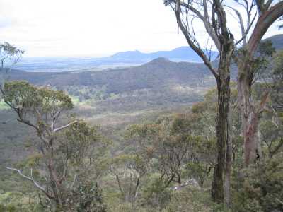
| View from Eversley Sugarloaf |
Eversley Sugarloaf Summit Walk (180 km
W). Access is from the Western Highway, via the Ben Nevis Rd, until Cowan's Tk is reached. Drive down this track - the
walk starts and finishes at the junction of Red Rock Track and Cowan's Track. Follow Red Rock Tk to a yellow marker on a tree,
turn left up an old loggging track (this is a short-cut), until Cowan's Tk is reached. Continue along Cowan's Tk to where
it meets Eversley-Sugarloaf Tk. The summit is up a short steep climb. Return along Eversley-Sugarloaf Tk,
bypassing the Cowan's Tk turn. Continue until Ben Nevis Rd is reached, and follow this to Cowan's Tk turnoff. Continue along
Cowan's Tk to the Red Rock Tk junction. Superb views from the summit to the north,
with Ben Nevis and the Red Rock massif prominent, and the Pinnacles and Pyrenees' Regional Park in the distance. Maximuy altitude
reached 721m. (5 km, two hours, August 2006)
|
|
|
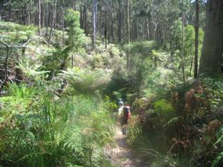
| The Glut Track |
The Glut Walk (180 km W). Access from the Western Highway at Beaufort,
through Raglan, to Richard's Picnic Ground. Follow the signposted Grevillia Track for about 700m to the Glut Track junction,
continue for another 1.1 km to the Glut Picnic Ground. Continue along the signed Woods Gully Track for 1.4 km to a gate, follow the Glut Road back to the picnic ground. Return
to Richard's Picnic Ground. The Grevillia Track forms part of the long ((17 km) Beeripmo Walk. Pleasant hiking through the
forest and past lush fern gullies. (Two hours, 6 km, November 2006)
|
| View from Mt Lonarch |
Mt Lonarch Summit Walk (180 km W). At Beaufort, take the Raglan Rd, then
the Raglan-Elmhurst Rd, Flume Gully Rd, Tower Rd. The road ends at the communications'
tower at the summit. The final 1 km is steep and rough, best done with 4WD. Impresssive views towards the
east and north from the lookout near the summit (790m asl). The walk is short - use the old jeep track past
the lookout, which follows the Telstra cable - continue downhill for about 1 km where the track becomes indistinct, then turn
around and return. Interesting forest walking. (2 km, 45 mins, September 2006).
Photos | Map
|
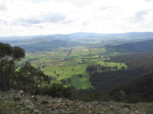
| Paradise Valley |
Paradise Walk (180 km W). Access: Western Highway, Beaufort, Raglan,
Glut Rd, Glut Picnic Ground. Walk starts here, signposted. Proceed along Track, negotiate small weir over Fiery Creek.
Climb steadily through bushland, passing beautiful fern trees and gullies.
Go down and up another creek gully. Track becomes overgrown and indistinct in thick ferns after about 30 mins - this
is the turnaround point. Return to start. (3km, 1 hour, December 2006).
Photo Album | Map
|
| |
South Boundary Track - Mt Cole. (180 km W). Western Highway, Beaufort, Raglan, Main
Mt Cole Rd, to small car park at Ditchfield Rd. Walk up Ditchfield Rd, reaching junction with Frees Point Rd. Left turn into
Frees Pt Rd, which flanks Mt Cole, then on to South Boundary Tk for 3 km. Return to transport. Excellent
views across the valley, rugged bushland, former logging area. (8 km, 2 hrs, Jan 2008)
Photos | Map
Mt Cole Summit. (180 km W). Western Highway, Beaufort, Raglan, Main Mt Cole Rd, Ditchfield Rd, to small car park at junction with Frees
Pt Rd. Turn left along Frees Pt Rd, reaching a junction marked "Mt Cole Track". This is the start of the summit loop. Follow
this track to the right, first section is steep, then continue anti-clockwise, eventually arriving back at the start.
Return to transport. Excellent views from Frees Pt Rd, large granite boulders at the summit.
The actual summit is about 20 m higher than the track. (4 km, 1.5 hrs, March 2008)
Photos | Map
Frees Point Track - Mt Cole. (180 km W). Western Highway,
Beaufort, Raglan, Main Mt Cole Rd, Ditchfield Rd, to small car park at junction with Frees Pt Tk. Go through gate - continue
uphill, take a right turn at a junction, follow this to main Mt Cole Rd. Return to the junction. At the junction, turn
right, descend steeply - this is Old Dairy Maid Tk. Follow this tk for about 1.5 km through the Dairy Maid Creek Gully. Turnaround
and return to car park. Beautiful forest, huge granite boulders, ferns, gullies.
(10 km, 2 hours, Feb 2008).
Photos | Map
Ben Major Summit Walk. (160 km W). Western Highway, Beaufort, Amphitheatre
Rd, turn right on to Ben Major Track, drive through Ben Major Flora Reserve. Park car about 3 km along this dusty, stony,
steep and rough 4WD track, part way up Ben Major. Walk about 2 km to the Summit, explore and return to car. The 360 degrees panoramas were among the best we have seen in this part of Western Victoria. (4
km, October 2006, 1.5 hr)
Victoria Hill Walk. (160
km W). Access: Western Highway, Beaufort, Raglan, Main Mt Cole Rd, Victoria Mill picnic ground. Climb short foot-track
to Mt Cole Rd, cross this road, go through gate, climb track adjacent to acacia plantation. Continue until summit is
reached then return to a junction, turn right, this is the Victoria Hill Track. Proceed on this jeep track to the junction
of Mt Cole Rd and Pinch Track, return to start back along Mt Cole Rd. Good views
from the summit to Ben Nevis Plateau. (3 km, 1 hr. March 2007). Photos | Map Berripmo Walk. (160 km
W). Western Highway, Beafort, Elmurst Rd, to Richard's Picnic Ground. This is a relatively new 21 km circuit walk, which
passes through the Mt Cole State Forest and Buangor State Park. The walk is designed as a two-day trip, with a suggested overnight
stop at Mugwamp Camp.We did this walk over five one-day trips, in the period October 2005 to March 2006.
The scenery, views, and forests were magnificent, with track markers at the major junctions.
The view from Mt Sugarloaf was outstanding.
A side trip to Mt Buangor Summit
was done as a separate walk.
Walk 1: Raglan Falls Section: Photos
Walk 2: Cave Hill Section : Photos
Walk 3: Mt Sugarloaf Section: Photos
Walk 4: Mugwamp Section: Photos
Walk 5: Grevillia Section: Photos
Map and Track Notes
|
| View from Cave Hill |
|
|
|
|
|
|
|
|
|
|
|
|
Distances to the start of walks, from Melbourne, are in brackets against
their descriptions
|
|
|
|

