BEGINNINGS
The Maroondah Aqueduct scheme was
commenced in August 1886, from the design and under the direction of Melbourne Water Supply engineer William Davidson.
It would become one of Melbourne's three major water distribution facilities - the others were
the O'Shannassy and Yan Yean systems.
Davidson’s work was central to the provision
of Melbourne’s early water supply. He devised the construction of the Wallaby and Silver Creek systems, diverting northern
flowing water to the south, to augment and provide clean water flows for the Yan Yean Reservoir system.
He went on
to design and construct the Maroondah Aqueduct system, as well as securing the reservation of bush land near Melbourne, to
be retained as closed catchment for future Melbourne water supply. He had a distinguished public career and went on to become
Inspector General of Public Works.
COMMISSIONING
Work began on the Aqueduct in 1886. Originally, it extended from the former Watts Weir, subsequently from the Maroondah
Reservoir, delivering water to the Preston Reservoir.
The Aqueduct
system was opened by the Governor of Victoria, the Earl of Hopetoun on February 19, 1891. providing a clean, reliable source
of water for the growing city of Melbourne.
DESIGN
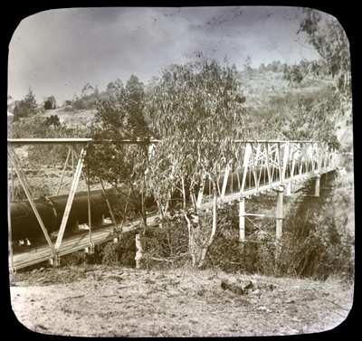
It
was 66 km long, with 41 km of open cement and brick lined channels and pipes, 10 km of tunnels, and 15 km of inverted syphons
to carry the water over ravines.Three tunnels were around 1.6 km each, the longest of which was 97 chains, in the Long Gully
Range.
The syphons were made from riveted wrought iron. Air compressors and rock borers
were used.
Riveted wrought iron was chosen as it was lighter than cast iron
The open channel sections were 11 ft 10 inches wide, and 4 ft 10 inches deep. The
sides sloped 45 degrees. The bottom was in the arc of a circle.
Domestic water supply aqueducts of any size are
(very) rare in Victoria. The size and nature of the Aqueduct, reflects Melbourne's growth during the late 19th century, as
well as the program of major public works undertaken then, which included the first sewerage system.
It was designed to carry 50 million gallons per
day, but the capacity was 28 million gallons on commission ing.In 1908, its height was raised, and by 1915 it
was carrying 29 million gallons per day.
It was enlarged in the 1920s, and has cultural
significance as a major engineering structure which played an important part in the development of Melbourne's water supply
system.


