Bright Pictorial Heritage 1850 to 2011

Porepunkah

Home
About this Project
Brief History of Bright
Historical Timeline
Old Tobacco Sheds and Gold Museum
Boys' Camp
Bright Cemetery
Courthouse and Lockup
Beautiful Trees in Bright
Bushfires
Memorial Arboretum
Gold Mining
Canyon Gold Sluicing Site
Freeburgh and Germantown
Forestry
Baker's Gully Reserve
Bright Railway 1890 to 1983
Early Horseraces
Early Miniature Car Races
Huggin's Lookout
Clear Spot, Apex, Tower Hill Lookouts
Walking Tracks
Wandiligong
Porepunkah
Maps
References and Bibliography

1880porepunkah.jpg
1880 Porepunkah, at Temperence Hotel

1886porepunkah.jpg
1886 Porepunkah

1892porepunkah.jpg
1892 Porepunkah - Temperence Hotel

1900porepunkah.jpg
1900 Porepunkah

1910porepunkah.jpg
1910 Porepunkah

1912porepunkah.jpg
1912 Porepunkah

1915porepunkah.jpg
1915 Porepunkah

1930porepunkah.jpg
1930 Porepunkah

1935porepunkah.jpg
1935 Porepunkah

1940porepunkah.jpg
1940 Porepunkah

1915porepunkahbridge2.jpg
1915 Porepunkah Bridge under construction

1914porepunkahbridge.jpg
1914 Porepunkah Bridge under construction-

1913monier3.jpg
1913 MOnier Bridge under construction

1913monier2.jpg
1913 Monier Bridge under construction

1913monier1.jpg
1913 Monier Bridge

2008porepunkahmonierbridge.jpg
2008 Monier Bridge

mtbuffaloporepunkah1880.jpg
1880 The Porepunkah to Mt Buffalo coach service!

Porepunkah is a small town located on the Great Alpine Road, 6 km  north-west of Bright and is the gateway to Mount Buffalo and the surrounding national park.

The town's small commercial centre, featuring a general store, a hotel and a few speciality shops, overlooks the picturesque Ovens River and is surrounded by forests and scenic mountain ranges. Apex Park is located on the banks of the Ovens River, offering attractive picnic and BBQ spots. For visitors who want to want a bird's eye view of the beauty of the surrounding area, scenic flights are available from the Porepunkah airfield.

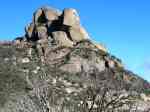
Access to the Mount Buffalo summit is via Porepunkah from the town's main road junction where the Great Alpine Road meets the Mount Buffalo Road and the road to the scenic Buckland Valley.

The historic Mount Buffalo Chalet is located 14 km before the summit, offering accommodation as well as a cafe and gift shop for day visitors (Chalet currently closed until new lease holder takes over). A number of scenic walking tracks and lookouts are easily accessible from near the Chalet, and they lead to several natural attractions including the Crystal Brook Falls.

Porepunkah was one of the first gold-mining hamlets in the 1860s. The Temperence Hotel , 1878 to 1940, stood on the banks of the Ovens - remains of its foundations and pathways survive, next to the Bridge.

An interesting signed walking track starts at the Bridge and follows the Ovens in a circuit.

The Monier Bridge over the Buckland River was built in 1914 as the main access point to Mt Buffalo - it survives today and now leads to private property.

2010porepunkah1.jpg
2010* River Walk info board

2010porepunkah2.jpg
2010* Buffalo from Porepunkah

2010porepunkah3.jpg
2010 Ovens River at Porepunkah

2010porepunkah4.jpg
2010 Bridge at Porepunkah

2010porepunkah5.jpg
2010* Ovens at Porepunkah

2010porepunkah15.jpg
2010* Ovens at Porepunkah

2010porepunkah17.jpg
2020* Site of Temperence Hotel

2010porepunkah18.jpg
2020* Site of Onley's Bakery

2010porepunkah19.jpg
2010 Ruins of Temperence Hotel

2010porepunkah20.jpg
2020 Ruins of Temperence Hotel

2010porepunkah21.jpg
2020* Ruins of Temperence Hotel

2010porepunkah22.jpg
2010* Site of Temperence Hotel

Comments welcome, to  Bob Padula