The
Present
Whilst the majority of the open channel aqueduct remains in place today
(albeit in a dilapidated and largely overgrown state) the most obvious legacy of this amazing undertaking is the almost flat
and very solid access road which was formed adjacent to the channel. This road forms the surface of the trail and remains
in good condition today.
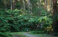
The O'Shannassy
aqueduct trail is undoubtedly one of Victorias most spectacular and most appealing walking / riding routes. Zig zagging
its way along the side of the mountains, surrounded by dense forests and huge mountain trees, the trail offers spectacular
views, fantastic photography opportunities and an amazing sense of peace, tranquillity and harmony with nature.
The upper trail is now readily accessible by vehicle from
several points, including Dee Road, Surrey Road and Yuonga Road. Parks has provided signage and limited facilities and
the trail is becoming an increasingly popular destination for enthusiasts and familes alike. The almost level
nature of the trail enhances its appeal to all ages and fitness levels, including the disabled. Further extensions to the
trail and facilities are underway.
The Mt
Evelyn sections of the trail are particularly well used and, being now very close to well-developed residential areas, provide
a very pleasant and popular destination for residents and visitors of all ages and backgrounds.
Sadly, very little of the background to the aqueduct
and its original purpose and story are known or appreciated today. Much of the knowledge and history pertaining to the
aqueduct has been lost. Hopefully, this site will go some way to addressing that gap.