Centenary of the O'Shannassy Water Supply System - 1913 to 2013 - a Pictorial Heritage

O'Shannassy Aqueduct Trail - Cement Creek Rd to the Weir

Home
Introduction
1803 - Beginnings
1892 - Surrey Hills Reservoirs
1911 - Design and Construction
1911 - The O'Shannassy Weir
1914 - Maintenance and Operations
1923 - Bushfires, Landslips, and Floods
1924 - Modifications and Enlargements
1927 - Silvan Dam
1927 - Mt Evelyn Aqueduct
1928 - The O'Shannassy Reservoir
1929 - Upper Yarra Conduits
1931 - Silvan Inlet Aqueduct
1996 - Decommissioning
2006 - Pigging Project
2007 - O'Shannassy Aqueduct Trail - Overview
O'Shannassy Aqueduct Trail - Parrot Rd to Don Rd
O'Shannassy Aqueduct Trail - Don Road to Dee Rd
O'Shannassy Aqueduct Trail - Dee Rd to Sussex St
O'Shannassy Aqueduct Trail - Sussex St to Yuonga Rd
O'Shannassy Aqueduct Trail - Yuonga Rd to Donna Buang Rd
O'Shannassy Aqueduct Trail - Donna Buang Rd to Cement Creek Rd
O'Shannassy Aqueduct Trail - Cement Creek Rd to the Weir
The Present
Epilogue
Timeline
Bibliography
The Author's Websites

cementcreekchlorineshed.jpg
Cement Creek chlorine shed in 2006

cementcreekhut.jpg
Cement Creek Hut in 2012

O'Shannassy Aqueduct Trail - Cement Creek Rd to the Weir - 7.6 km
 
Access to this entry point is at a car park at the end of Cement Creek Rd, from the Woods Point highway.
 
This is a badly potholed road, and care is needed in 2WD vehicles. In winter, pools of water across the road make driving difficult. It passes the Heritage Pine Plantation.
 
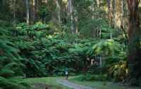
The trail continues on its merry way 7.6 km to the O'Shannassy Weir, the end of the journey.
 
East of the Cement Creek junction the aqueduct is buried pipe, and some of this is visible along the edge of the track. A caretaker's hut and storage room is found about 1 km out, which is the start of the open channel.
 
This hut is well preserved, and contains a fireplace, chairs, tables, and some furnishings!
 
From this point, the track passes through tall forest, reaching the weir precinct.
 
This is a long 7.6 km stretch and there are no intermediate public access points. Various structures still exist along its length, including small storage huts.

Points of Interest

  • Crossing of Cement Creek
  • Syphon
  • Old hut
  • Pipe converts to open channel
  • Surviving infrastracture at the Weir

cementcreekhut2.jpg
Inside the Cement Creek Hut in 2012

cementcreekpipe.jpg
Cement Creek pipe in 2012

weir6.jpg
Old hut, near Weir, used for the former electricity power generator

weir4.jpg
Near the Weir (2012)

weir5.jpg
Near the Weir (2012)

weir1.jpg
Near the Weir (2012)

aa26cementcreekrd.jpg
Cement Creek Rd car park (2012)

.

Contact the Author