The Forests of Warburton - a Pictorial Heritage - 1853 to 2012

1907 to 1913 - Richards Mill

Home
Scope
1853 - Beginnings
1885 to present day - Dee Valley Mills
1889 to 1919 - Mills in the Wesburn and Old Warburton area
1890 - Roads to the Forests
1901 to 1964 - The Warburton Railway
1902 to 1906 - Anderson's Mill
1902 to 1939 - East Warburton and Onwards
1903 to 1907- Robinson's Mill No. 1
1905 to 1949 - Tramways of the Mills
1905 to 1928 - Parbury's Brookfield Mill
1906 - Wondwondah Estate and the Adventist Church
1907 to 1913 - Richards Mill
1907 to 1922 - Robinson's Mill No. 1
1908 to 1922 - Robinson's No 2 Mill (Cement Creek)
1909 to 1916 - Hermon's Mill (La La Estate)
1909 to 1949 - The Warburton Steam Railway
1911 to 1915 -The O'Shannassy Aqueduct and Weir
1915 to 1973 - Brimbonga Seasoning Works - East Warburton
1918 to 1925 - Sunnydale Mill, East Warburton
1919 to 1920 - Slocum and Walker's Mill
1920 - From the Bush to the Bungalow
1922 to 1932 - Enterprise Mill (La La)
1925 - Family Snow Trip to Mt Donna Buang
1932 to 1937 - Horner's Mill
1938 to 2000 - Tuckman's Mills
1950 - Welcome Back to Warburton
The Donna Buang Range
Timeline
Epilogue
Bibliography
The Author's Personal Websites

siterichardsmillearth.jpg
Site of Richard's Mill

richardsmillbridge1913.jpg
1913 - Richard's Mill Bridge at bottom of Brisbane Hill Rd

bridgerichardsmill.jpg
Bridge over Aqueduct, Richard's Mill tramway (author's pic July 2012)

richardsbridgeconstruction.jpg
1907 - constructing Richard's Mill Bridge

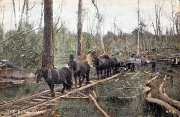
Richard’s Mill – 1907 to 1913

William Richards built a mill in 1907 high up on the slopes of Mt Donna Buang, about 1 km north of the O’Shannassy Aqueduct.


He had also built a “double-deck” bridge over the Yarra to carry a tramway with sawn logs to the railway station. This followed the present-day Brisbane Hill Rd.

The Mill was supplied with logs from a winch-hauled incline, starting very close to the present-day Mt Donna Tourist Rd. The actual location of the top of the incline is near the present-day "Yarra Valley Lookout"

The Yarra-Silvan underground conduit crosses this land, just down from the Aqueduct.

The concrete bridge over the Aqueduct survives to the present day and is in remarkably good condition, about 1 km west of the Mt Victoria Walking Track crossing.


This Mill closed down in 1913.

brisbanehillrd2012.jpg
July 2012 - south view from top of Brisbane Hill Rd (author's photo)

donnabuangjuly232012c.jpg
July 2012 - from Mt Donna Buang Rd, top of former RIchard's incline

brisbanebridge.jpg
July 2012 - Brisbane Bridge (author's pic)

newbrisbanebridgestreetview.jpg
August 2012 - Brisbane Bridge streetview

1951warburtonymca.jpg
Sep 1951 - author's schoolmate Andrew on the main Brisbane Bridge - YMCA trip

Contact Bob Padula