|
|
|
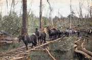
| 1908 - Warburton - Brisbane Hill - showing extent of cleared forest |
|
|
|
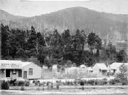
| 1908 - Warby main st, Mt Littlejoe in background |
History
The town of Warburton is about 70 km
east of Melbourne, and its development began in the year 1840, when Victoria was
in reality a part of NSW.
The State of Victoria was proclaimed in 1851, with Melbourne as its capital. Before that, the area now known as the Upper Yarra was inhabited by the Yarra
Yarra tribe of Aborigines. With the arrival of European settlers, tribal number declined.
In 1845, Robert Hoddle, the first Survey General, of Port Phillip journeyed into the upper reaches
of the Yarra.
The first
person recorded as having title to freehold land in the area was Mr E. Buller, in 1851, who had secured 20 acres.
Prior
to the discovery of gold in the Yankee Jim’s Creek area, the Warburton locality had been included as part of the Parambool
Pastoral Run, about 16,000 acres, and was first leased in 1853.
Gold Mining
In
1858, gold mining commenced in the Upper Yarra at Britannia Creek and in the Reefton
and McMahon's Creek districts.
Yankee Jim's Creek goldfield opened in 1859.
It was renamed Warburton in 1863 after the gold warden for the district, Charles
Warburton Carr.
In 1864, a liquor licence was issued to Mr E. Buller and his hotel helped
to serve the needs of the mining community
In 1865,
an approximate map published by the Crown Lands Dept. incorporated the explorations and findings of Mr J. A. Panton,
one time gold warden for the district.
The gold mined was mainly alluvial (as opposed
to reef) and deposits were reported to be 'of the most substantial character'. The wash was two feet (600 mm) thick at a depth
of 70 feet (21 m) resting on a granite bottom with nuggets of seven ounces (200 gm) in weight. In 1870, a water wheel was
built at Warburton to drive a battery which crushed the gold-bearing rock. This was located at the Shining Star mine, one
of the few reef mines. As alluvial deposits became exhausted, miners went to Woods Point where larger reefs existed. By the
late 1890's, most of the 'easy' gold had been found and prospectors had moved on, leaving only a few settlers in the town.
The name “Warburton” has been shared between two townships
over the years. The mining town of “Yankee Jims Creek” was located on the gold-bearing slopes of Mount Little
Joe, and was renamed “Warburton” after the mining warden of the district, Charles Warburton Carr. Gold depletion
caused a declining population in the 1880s, so the town was renamed “Old Warburton” and the town of “Upper
Warburton” on the banks on the Yarra River was renamed “Warburton”.
In the 1880s, a new road (now the Warburton Highway) was cut along the Yarra River, ending any further
development of Old Warburton.
A population shift to the Scotchman's Creek area, where the Alpine Retreat
Hotel was built, occurred for commercial benefit,
causing the reestablishment of Warburton there
as a tourist and timber town.
|
|
| 1864 - watercolor of Warburton |
|
|
| 1914 - postcard of Yarra at Warburton |
|
|
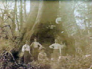
| 1901 - a very big tree at Warburton |
|
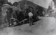
| 1930 - Elephant hauling timber in main street, Warby |
Timber Industry
A
timber industry took over in Warburton as gold ran out. Axemen cut wagon loads of palings which were taken over rough bush
tracks to Lilydale, the railhead at that time. The railway was extended to Warburton in 1901.
Numerous sawmills and
timber tramways developed throughout the area supplying timber to the trainline for transport to Melbourne. The narrow gauge
tramways were so named because an Act of Parliament preventing anyone but the Government from operating trainlines.
Steam and diesel engines were used to power
the sawmills and haul the logs. In some cases the logs were lifted by cable and pulley high above the ground to carry them
to mills and railheads. In more remote areas, horses were used to pull empty bogies up graded lines. When loaded with logs,
the bogies would run downhill under the control of braking systems. The mills provided work for all who wanted it, and towns,
such as Powelltown, sprang up around some of the mills. A few of the timber tramway tracks remain open to walkers but chain
saws, bulldozers and timber jinkers replace the older methods of felling and transporting timber.
A few of the timber tramway tracks remain open to walkers but chain saws, bulldozers and timber
jinkers replaced the older methods of felling and transporting timber
In the years from
1900 to 1950, about 1.75 million tons of timber was sent by forest tramway and railway - it was a Mountain of Ash, and 66
major sawmills and many smaller mills were established in the bush surrounding the town.
Railway
In 1901,
the railway from Lilydale to Wesburn, Millgrove and Warburton opened, which was linked to an amazing system of
wooden and steel railed tramways. Over 320 km of tramways operated in the region. Horse, steam locomotives, bullocks and rail
tractors were employed in hauling the timber along the rails
Logging initially saw entire mountainsides ultimately
denuded of most trees, particularly on the slopes of Mts Donna Buang, Ben Cairn, and Victoria.
By the the late
1920s, most of the prime timber near Warburton had been logged, and activity had moved further out to the forests of Big Pats
Creek, Starvation Creek, Cement Creek, the Mississippi Creek, Big Pat's Creek, Reefton, McMahon's Creek and beyond.
The Powelltown area
was also heavily logged, with a merging with the Warburton area at Starling Gap,
Bushfires
Catastrophic
bushfires of 1898, 1902, 1906, 1923, 1926, 1932 and 1939 devastated much of the forests around Warburton, with terrible loss
of life and property and resulted in the Government in 1940 forcing all surviving mills to relocate outside of the forests
|
| 1905 - Warburton store |
|
|
| 1895 - Horses and buggy at Warburton |
|
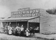
| 1913 - Hutchinson's Store, main street Warby |
|