The Forests of Warburton - a Pictorial Heritage - 1853 to 2012

1902 to 1939 - East Warburton and Onwards

Home
Scope
1853 - Beginnings
1885 to present day - Dee Valley Mills
1889 to 1919 - Mills in the Wesburn and Old Warburton area
1890 - Roads to the Forests
1901 to 1964 - The Warburton Railway
1902 to 1906 - Anderson's Mill
1902 to 1939 - East Warburton and Onwards
1903 to 1907- Robinson's Mill No. 1
1905 to 1949 - Tramways of the Mills
1905 to 1928 - Parbury's Brookfield Mill
1906 - Wondwondah Estate and the Adventist Church
1907 to 1913 - Richards Mill
1907 to 1922 - Robinson's Mill No. 1
1908 to 1922 - Robinson's No 2 Mill (Cement Creek)
1909 to 1916 - Hermon's Mill (La La Estate)
1909 to 1949 - The Warburton Steam Railway
1911 to 1915 -The O'Shannassy Aqueduct and Weir
1915 to 1973 - Brimbonga Seasoning Works - East Warburton
1918 to 1925 - Sunnydale Mill, East Warburton
1919 to 1920 - Slocum and Walker's Mill
1920 - From the Bush to the Bungalow
1922 to 1932 - Enterprise Mill (La La)
1925 - Family Snow Trip to Mt Donna Buang
1932 to 1937 - Horner's Mill
1938 to 2000 - Tuckman's Mills
1950 - Welcome Back to Warburton
The Donna Buang Range
Timeline
Epilogue
Bibliography
The Author's Personal Websites

new3warburtoneastmapbonzle.jpg
2012 - Location map

Overview
When most of the accessable timber was being quickly removed from the forests near to Warburton by the mid-1920s, timber cutting atttention was then being given to the areas further to the east, beyond East Warburton.
 
In the Upper Yarra area, from as early as 1902, many mills operated along Braham's Creek, Crooked Creek, Starvation Creek and McMahon 's Creek, which are on the south side of the present-day Warburton to Woods Point Rd.
 
Mills also operated along on the north side of the Woods Point Rd. including the Cement Creek East and West Branches, and in the area which was later absorbed by the O'Shannassy Reservoir.
 
However, much of the timber in those regions had been cut out by the late 1920s, with some mills having been destroyed in the fires of 1925/1926. 
 
A few mills still operated to the late 1930s, but the 1939 fires ravaged the area and were lost.
 
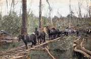
Timber from these mills was usually transported along tramways, to link with the main tramway along the Woods Point Rd. This operated until the late 1920s, and extended from the junction of the Warburton Steam Railway to Braham's Creek.
 
Many of these tramways ultimately became part of present-day Melbourne Water's network of management roads, with no public vehicle access.
 
In 1967, the water catchment areas in the region were closed to public access, to improve flow into the O'Shannassy Aqueduct, augmenting Melbourne's main supply.
 
In the decades since, there has been extensive regrowth, which is apparent on the northern side of the Aqueduct Trail, between the Cement Creek Rd entry point, all the way to the O'Shannassy Weir.

Cement Creek Rd
This links the Woods Point Rd with the A
queduct. There is no longer any public access north of the Aqueduct, at the Trail entry point. The Melbourne Water management roads leading north of the Aqueduct were originally logging tracks with tramways, bringing sawn timber from the mills.

The Cement Creek West Branch crosses the Cement Creek Rd a short distance down from the Aqueduct. Just to the west is the site of Yelland's and Duncan's Mill, which operated between 1902 and 1907. As recently as 2001, artefacts were visible near the Creek.
 
The Creek joins the Yarra to the west of Cement Creek Rd, and the area is now within the Yarra Rangs National Park.
 
Running parallel to the Cement Creek Rd was a tramway, in the years up to the late 1920s, which joined the Wood's Point Rd.


crookedcreektrack.jpg
Sep 2012 - Crooked Creek Track(author pic)

Bill Downey's Mill
The Crooked Creek Track is the alignment of the timber tramway carrying timber using a horse-team from Bill Downey's Mill, some 3 km upstream from the Woods Point Rd. Road trucks then took the timber to Warburton.

This Mill operated from 1937 until 1939, when  fires destroyed much of the forest above the Mill, which was forced to close.

The old tramway
alignment is now a walking track, known as the Crooked Creek Fireline, following the creek gully - it is accessed by a gate at the Woods Point Rd, about 1 km east of the O'Shannassy Lodge Rd.

The Yarra-Silvan Conduit interects the Track about 1 km from the gate.

pipeline1c.jpg
Aug 2012 - access track on Wood's Pt Rd to pipeline (author's pic)

Upper Yarra Reservoir and Pipelines

This reservoir was opened in 1957, and its output is carried by a mix of open channel and underground pipe to the Silvan Reservoir. There are two conduits - the Yarry Valley Conduit and the Yarra Silvan Conduit. Filtration plants are sited along the routes. Melbourne Water management/maintenance/fire tracks lead from the Woods Point Rd to the conduit routes - these may be explored on foot, and pass through the Yarra State Forest.

pipeline1a.jpg
Aug 2012 - Route of the Pipeline - west view to Mt Victoria (author's pic)

pipeline1b.jpg
Aug 2012 - Route of the Pipeline - west view to Mt Victoria (author's pic)

cementcreekplantation.jpg
Aug 2012 - Plantation (author's pic)

cementcreekplantation2.jpg
Aug 2012 - Plantation (author's pic)

Heritage Pine Plantation

The Heritage Pine Plantation is now part of the Yarra Ranges National Park, and is reached from a small carpark in the Cement Creek Rd, about 2 km north of the Wood's' Point Rd.

Public vehicle access is not permitted - walkers enter next to a locked gate.The site is managed by Yarra Ranges Shire.

The Plantation was created in the 1920s, as an experimental project to assess
growth properties of tree varieties.

Trees were planted from seed in a large cleared area from which all Eucalyptist timber had been cut out for the mills.

Assessment of tree growth continued into the 1960s, when the project was terminated.

An inspection of the Plantation is a rewarding experience, the perimeter of which is about 2 km. Adjacent is the Cement Creek, which flows strongly to its confluence with the Yarra nearby.

cementcreekplantation1.jpg
Aug 2012 - Plantation (author's pic)

Contact Bob Padula