Roads to the Forests
In the 1860s, “Mount Acland” was the name given to the 1,250m high mountain by a Police Magistrate
called Joseph Anderson Panton. The name it has today, “Mount Donna Buang”, came from the Wurundjeri
Aborigines.
There were no roads to the Donna Buang Range in those years, and the forests
were unexplored.
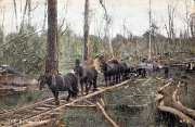
A rough walking track to the summit of Mount Donna Buang was cut during
the 1890s and the much wider Donna Buang Bridle Track was blazed in 1911. This was for horses and foot-traffic, and continued to Healesville, past Ben Cairn and
Malleson’s Lookout.
In
1912, the vehicular road to the Turntable was opened, followed by the road to
the summit.
The
original Bridle Track was actually hacked out of the mountainside for use by the then Melbourne Water Board for maintenance
and inspection activities.
Warburton was a two-hour train journey from Spencer Street, so a day trip to
the top was possible if you hired a horse in the township to ride to the summit. A primitive timber lookout at the top gave
spectacular views as far to the Victorian Alps in one direction and Port Phillip Bay in the other.
In 1928 a steel Lookout Tower at Donna Buang replaced the old wooden structure, which was actually
a poppet head brought from the Bendigo mines, and previously at Wood's Point.
In 1912,
a new Marysville to Donna Buang Horse Track was cut via Acheron Gap, Mt Ritchie, Mt Strickland, and Keppell's Lookout. This
track passed along the O'Shannassy watershed and a waterfall on Deep Creek cascading to a depth of 100 metres.
In the
1920s, there was a further boost
to tourism when motorized vehicles were able to make the journey and it became a popular day trip destination for the citizens
of Melbourne.
The mountain also became known as the closest snowfield to Melbourne.
In
1924, the Ski Club of Victoria built an 8-foot-wide (2.4 m) track for skiers
on the top of Mount Donna Buang. Being the nearest location to Melbourne where you could ski, the mountain was well patronised
and both the Ski Club of Victoria and the Melbourne University Ski Club built huts on the mountain to cater for their members.
During the 1930s the Warburton Ski Club was officially formed as well. The first observation tower was erected shortly after
the bridle track was opened.
In
1926, a new vehicular road, known as the Acheron Way, was opened, linking the
Mt Donna Buang Rd at the Cement Creek Junction with the settlement of Narberthong.
The
road from Donna Buang to Healesville was intended to provide a high level vehicular route for travellers wishing to drive
from Warburton (or vice-versa).
In 1926, the new vehicular track from Mt
Donna Buang to Healesville was opened, passing Ben Cairn. Prior to this, there was no vehicular access between Ben Cairn and
Cement Creek.
Unfortunately,
the authorities at the time did not understand that this route was buried under snow in winter, and in later years it was
closed for the winter months.
Woods Point
The
present-day Warburton to Woods Point Rd was a rough track in the late 1890s. It passed through the small settlement of
Walsh's Creek, where McVeighs Hotel was located.
In 1898, a coach service operated between Warburton and McVeighs, which was later extended
to Woods Point. Newspaper reports of the 1920s and 1930s era advised that the road was in very bad condition, and it
was subsequenty upgraded in 1946.
The track to Wood's Point, as well as Walsh's Creek and McVeighs, were submerged when the Upper Yarra Reservoir
was built in 1957. A waterwheel, and an information board at the main picnic area at the Upper Yarra Dam describes the
history of McVeighs.
The present-day road from Warburton to Woods Point follows the Yarra Valley . but at a much lower altitude
than the original track