|
|
|
| 1906 - At the Signs publishing building |
|
|
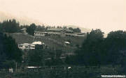
| 1906 - Signs publishing building, and staff houses, photographed from the present-day Wood's Pt Road |
|
|
| 2011 - Adventist Retirement Village (author's photo) |
|
|
| July 2012 - Yarra next to Signs Bridge (author's photo |
|
|
| 1934 - La La bridge destroyed in floods, Signs printing factory in distance |
|
|
| 1984 - Sanitarium Factory |
Seventh Day Adventist Church
From the early 1900s there was a strong presence of the Seventh
Day Adventist Day Church in Warburton.
On June 6, 1885,
three Adventist preachers, Stephen Haskell, John Corliss and Mendel Israel, a printer, Henry Scott, and an experienced door-to-door
literature salesperson, William Arnold, travelled from San Francisco to Sydney.
The SDA Signs Publishing Company first began as the Echo Publishing
Company, in North Fitzroy, a suburb of Melbourne. By 1889 the Echo Publishing
Company employed 83 people and was the third largest Seventh-day Adventist publishing house in the world.
The management were committed to the printing and distribution of
Seventh-day Adventist literature but were also commercially successful-so successful, in fact, that they soon became the unofficial
government printers for Victoria. The church decided this was moving in the wrong direction, so decided on a move to Warburton
in 1906, where the operation could return to its religious roots.
However the move deprived the company of the considerable income
created by the outsourced work, thus funding for religious material was at a premium. Cheap hydro-electricity and abundant
land for both factory premises and staff housing were the predominant reasons for the choice of location.
|
|
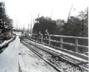
| 1906 - the Wonwondah Bridge |
|
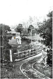
| 1906 - the Wonwondah Gate and Bridge, Signs printing factory in distance |
Wonwondah Estate
In
1905, some 350 acres (110 hectares) of land had been acquired by the
Church, known as the “Wonwondah Estate”, which was purchased from a local sawmiller. This parcel of land extended
easterly from the Yarra, and included “Signs Hill”, and the present-day residential areas along Yuonga Rd, Salisbury
Avenue, Upper Blackwood Ave, Ellis Court, Anderson’s Rd, Wattletree Rd, and Piedmont
Ave.
Its eastern boundary was approximately
at the Rocky Creek, and to the south it abutted the Yarra.
The northern boundary is not known
precisely, but it is believed to have extended past the O'Shannassy Aqueduct.
Access was via a wooden gate at
the privately owned Wonwondah Bridge (washed away in the 1934 floods
and subsequently rebuilt as the present-day Signs Bridge).
A coach track went from the Bridge
to the factories.
Another track, later known as the
Wonwondah Rd, linked the bridge to the Yarra, passing Robinson's Wonwondah Sawmill - this track became part of the Warburton Caravan Park in the early 1950s,
and was officially discontinued in late 2011.This Mill (1903 to 1907) was sited on the Yarra bank, next to the bridge - the
site is now part of the Caravan Park and the River Walking Trail passes through it.
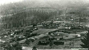
In 1906 the SDA Signs Publishing Company was formed and a double-storey printing factory was built in 1906 close to
the Rocky Creek, and several houses were built on the Signs Hill to accommodate employees.
In 1925, an
additional building was completed, known as the Sanitarium Health Food Factory, which was located adjacent to the printing
factory. Both of these structures were badly damaged in the 1934 floods
when the Yarra River flooded the valley and ruined a large part of the machinery and buildings, which were then demolished.
Power for the factories was generated on-site, with 240V AC for
lighting, and 110V AC for machinery. A 23 cm diameter stoneware pipe was constructed
to divert water from the Rocky Creek, running about 1 km to a specially built reservoir, and then down a narrow pipe to water-wheel,
which in turn drove a generator.
The present-day Warburton Retirement Village, next to the Yarra, stands on the land
originally occupied by the Sanitarium and Publishing factories.
A new, brick printing factory was built on higher ground in 1935 for £23,000, on the north side of the main road (now the Warburton Highway). Over
the years the building has gone through a number of extensions, the last major extension in 1979
cost $625,000, adding 21,000 square feet. The Signs building along with the Sanitarium building next door are now heritage
listed.
The first SDA Church in the district started in 1906 from
the Hill in a vacant house in Salisbury Avenue. In 1940 a new brick church
was dedicated opposite the rebuilt printing factory, and is a prominent landmark.
|
|
| 1930 - Signs printing factory (at left), and Sanitarium factory |
|
|
| 1929 - Sanitarium factory and motor vehicle |
|
|
|
| 1912 - the Hospital, showing cleared land on Sign's Hill |
|
| 1920 - Warburton Hospital |
Warburton Hospital
Warburton
Hospital has had a remarkable past. It was built by the Seventh Day Adventists and opened in 1912
as the Warburton Sanitarium, later becoming known to Victorians as the Hydro, because of the hydrotherapy treatments on offer.
It operated as a wellness centre
and fully fledged emergency hospital, with a maternity wing, for decades. But in the late 1990s, the Seventh Day Adventists
withdrew from the town and advertised the hospital for sale.
A sale was made in September
2000 to Prospa Pty Ltd, and the church ceased operations at the complex on March
14, 2001. Now, the complex remains closed.
The Hospital
was the last remaining legacy of the original SDA Wonwondah colony.
|
|
Wonwondah
Falls and Yuonga Falls
An article in the Melbourne Argus in 1903 reported that a hiking excursion had been made to the Yuonga Cascades
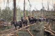
through the Wonwondah Estate, and the walkers used Robinson's Timber tramway for part of their journey.
In
1905, a further newspaper article reported that
a hike to Wonwondah Falls over the same route had been undertaken by members of the Warburton Field
Naturalists' Club.
No further reference to hiking trips made to these Falls has
been found, after 1905, despite extensive research into archived newspapers of the period.
However, in 1923, 1924, 1925, and 1926, the Argus published
identical tourist articles titled "Where to Spend a Holiday - Attractive Resorts - Warburton and the Upper Yarra".
These stories mentioned the Yuonga Falls and Wonwondah Falls, as desirable scenic destinations, both stated as being one and
a half miles from Warburton.
It was indicated that the Yuonga Falls were "on
the road to Donna Buang", and the Wonwondah Falls were " on Rocky Creek".
Rose Series postcards of the era show the Wonwondah Falls on
Wonwondah Creek, and one was titled "Rocky Falls Wonwondah".
The Rocky Creek flows down cascades to a crossing at the Mt
Donna Buang Rd - it passes under the O'Shannassy Aqueduct Trail about 100 metres east of the Yuonga Rd trail entry point.
The Yuonga Falls may have been located on Rocky Creek much
higher up the mountain. Several visits to the area by the author in July 2012 have not revealed any trace of these Falls.
The Yuonga Walking Track starts its steep uphill journey at the end of the unsealed section of Yuonga Rd and crosses Rocky
Creek. The track is now almost impassable, being overgrown and blocked with fallen trees, and emerges aout 2 km to the north
on to Mt Donna Tourist Rd. This follows the alignment of Robinson's timber tramway of the 1900s.
|
|
|
| Earth view of approximate boundary of the Wonwondah Estate as it was in 1903 |
|
|
| August 2012 - Sanitarium Factory, now derelict (author pic) |
|
|
| Aug 2012 - Redwood Community Centre (former Adventist school) (author's pic) |
|