|
|
|
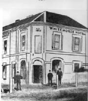
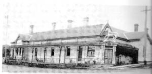
| 1853 - Whitehorse Hotel |
|
| 2013 - the White Horse |
This map is of historical significance. Note that the boundary between
Nunawading and Boroondara Parishes was approximately along present-day Warragul and Union Rds.
|
|
| 1853 - map of Parish of Nunawading |
|
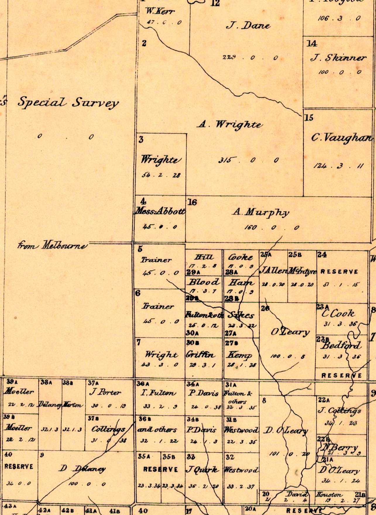
| 1864 - part of a Crown Lands map of the district which became Mont Albert and Box Hill |
MAIN ROADS
1850s The municipality’s first roads consisted of rough tracks used by timber cutters and
farmers. Rough tracks across the municipality had begun to be shown on maps: these included an approximation of Mont Albert
Road, which existed as a track from Barkers Road, in the west, east to Elgar Road.
1851
A Commission of Enquiry by the newly constituted Colony recommended that roads should be of
generous dimensions. New roads were to be three chainsb wide (66 yards)
1857 - A District Road
Board (Nunwading) was created, which would constuct and maintakn all roads in the area which had been surveyed by the Government.
1864
the Nunawading District Road Board had overseen the establishment of
the roads now known as Whitehorse Road, Canterbury Road and Burwood Highway.
1879 - north-south roads including the present Elgar Road, Station Street, Middleborough, Springvale,
Mitcham and Heatherdale Roads had been formed, formalizing the municipality’s present network of primary roads.
EVOLUTION
OF FIRST ROADS
Prior to the creation of the Road's Board in the 1850s,
roads and tracks were generally known by the names of land-owners. This practice was thrown out by the Board in favour of
names not linked to private individuals.
Canterbury Rd
1840 first known as Lower Nunawading Rd, and was renamed in 1856 as Delaney's Rd, after his hotel
on the road. It was further renamed to Canterbury Rd in
1873 after Viscount Canterbury,
the retiring Governor of Victoria.
1845 Delaney's Farm existed on West Creek, Main Creek Rd
(allotment "9" in 1864 map)
1850
Delaney's Rd was the main transport route
1853
Survey map shows the only house in Surrey Hills districts as Delaney''s Homestead, near Pine St/Broughton Rd
Warragul Rd
In 1840, Warragul Rd was known
as West Boundary Rd, and separated the Parishes of Nunawading and Boroondara.
Mont
Albert Rd
1841
- first known as Survey Rd, wich ran through Elgar's Special Survey, later to
become Mont Albert Rd, named after the hill "Mount Albert" near Barton St, north of Mont Albert Rd.
Whitehorse Rd
1851 it was known as Barkers Track then renamed Great
Gipps Land Rd, and later renamed Whitehorse Rd,
1852
Patrick Trainer built a coaching inn, the first change for Cobb and Coaches on the SE
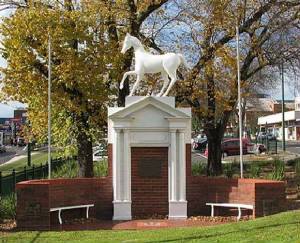
corner of Whitehorse and Elgar Rds. It was burnt down and rebuilt. It was demolished in 1935. Above
its doorway was a carved white horse which now stands in the centre of Whitehorse Rd on the main shopping area.
1866 Whitehorse Rd was declared
a Main Road to Lilydale.
Elgar
Rd (north of Whitehorse Rd)
1850
first known as Crossman's Rd
Burwood
Highway
1850
first known as Bennett's Rd (or Ballyshannassy Rd)
Station
St
1850
first known as Jim's Rd
Riversdale
Rd
1850
first known as Moloney's (or Chapel's) Rd
Middleborough
Rd
1850
first known as Fulton's Rd (between Hughbury Rd and Eley Rds). Between Eley and Canterbury Rds was known as Britinell's
Rd. Between Canterbury and Koonung Creek was known as Bladrman's Rd
Highbury
Rd
1859
first known as South Boundary Rd
Union Rd
1850s - was known as Simes Rd
1884
- was known as Surrey Rd
|
|
LAND OWNERSHIP
1840s the first surveys
were undertaken
1850
The first sale of freehold land in the Parish of Nunawading took place in 1850 in Box Hill. The pattern of early land ownership
was small blocks in Box Hill and Burwood, larger blocks in Blackburn and the largest lots in Vermont, Burwood East and Mitcham.
1840 Regulations at the time provided for the sale of blocks of Crown Land of eight square miles at
one pound an acre - a total cost of 5120 pounds had to be deposited in advance. The surveyed blocks had to be rectangular,
and had to be at least five miles distant from the nearest towns.
This meant that land could be secured almost anywhere.
1841
The first large land purchase was by Henry Elgar, an East Indian merchant who took up 5120 acres. known as "Elgar's Special
Survey" bounded by the present-day Elgar, Canterbury, Burke Rds, and Koonung Creek.
1843
Another large Special Survey was made north of the Koonung Creek, sold to Frederick Unwin
1850 The
first sale of freehold land took place in the Parish of Nunawading, with the exception of the Elgar Special Survey.
The pattern of early land ownership
was small blocks in Box Hill and Burwood, larger blocks in Blackburn and the largest lots in Vermont, Burwood East and Mitcham.
1850 Race meetings were held on land at the cnr of Broughton and Canterbury Rds
1851 The Colony of Victoria was created, separate from New
South Wales. Gold had been discovered in the nearby Warrandyte district, with a growing demand for land in the Nunwading area
in 1853 and 1854.
1852 The area now known as Box Hill North was surveyed,
and the blocks ranged in size from 19 to 55 acres.
1853 The first houses appeared in the district - one of these was
built by Delaney in 1853, as a hostelry, on the cnr of Broughton and Canterbury Rds (shown as allotment.
1853 In the Nunawading Parish, large tracts of land were
offered from Crown Lands for farms – some were bought and held for speculation,
later resold in the 1880s.
1854 Most Crown Land in the area had been sold
1854
Population in the Parish of Nunawading was 273. It was reported that Nunwading was a lonely and isolated spot, Schools and
Churches were being considered.
1857 Most
of the Parish was still undeveloped, in its natural state, apart from a few farms and embryo orchards.
FIrst Houses
Here
are details of some of the first houses which were built at the time:
1854 John White, house and farm in Harding
St
1856 Jacon Schneider,
house and vineyard in the Florence Rd area
1857 Nicholas Horn farm, continued until
1960 when subdivided into 27 house lots
1860 Craigg's Homestead, Windsor Crescent
1860s
Several farms existed in north Surrey Hills along West Creek, south of Whitehorse Rd
1871 John Woodland,
farm and hut, cnr of Union and Canterbury Rds
1860 Surrey Hills was the name of a property north of Whitehorse
Rd, between Union and Balwyn Rds, owned by Jemes Henty. The name Surrey Hills was used in the 1878 subdivison of 30 acres,
bounded by Mont Albert and Union Rds
|
| 1853 - Whitehorse Hotel |
|
|
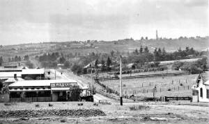
| 1905 - the Whitehorse Hotel (bottom right) |
|
|
| 1840 - Elgar's survey map (Source: Andrew W. Lemon, 1978) |
|