|
|
|
| Surveyors in 1865, using the "Chain" (NSW Roads Dept) |
HISTORY Early settlers recognized the value of the land in the Dandenong
Creek basin. The beautiful creek flats and
deep soil made the area an
early agricultural centre. By 1837 it was taken as a pastoral run, about
the same time as Melbourne was being settled. SQUATTERS
From 1836 legislation was passed
to legalise squatting with grazing rights
available for ten pounds per year. This fee was for a lease of the land, rather
than ownership, which is what the squatters wanted. The 1847 Orders in Council
divided land into settled, intermediate and unsettled areas, with pastoral
leases of one, eight and 14 years for each category respectively. From here on,
squatters were able to purchase parts of their land, as opposed to just leasing
it.
In the 1880s, subdivision of these large allotments was occurring across Melbourne, marketed by elaborately produced coloured
land-sale posters. Free train journeys from Flinders St and Princes Bridge Stations, and drays to the estates were provided
for potential buyers.
Individual allotments
in subdivisions varied in size, up to five acres.
MEASUREMENTS
Australian Land
maps of the 1800s and 1900s showed dimensions in the British system. One Chain was 66 ft (four Rods - 22 yards - cricket
pitch length - 20 metres). A Link was 7.92 inches. There were 100 Links in every Chain. A mile was 8000 Links. One Perch
(165 feet) was 25 links - also known as one Pole, one Rod
|
|
|
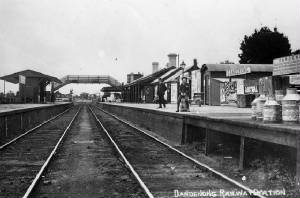
| Dandenong Station pre-1922 (SLV) |
|
|
| Dandfenong, main street, c1919 (SLV) |
|
|
|
| Dandenong main street 1922-1925 (SLV) |
TIMELINE
OF
EARLY HISTORY OF
DANDENONG
1837
Joseph Hawdon
established a pastoral run on Narra
Narrawong in 1837, bringing cattle from Sydney by land. Soon a few timber cutters and a police camp
were also located there. Dandenong Post Office opened on 1 July
1848
1840
Regulations at the time provided for the sale of blocks of Crown
Land of eight square miles at one pound an acre - a total cost of 5120 pounds
had to be deposited in advance. The surveyed blocks had to be rectangular, and
had to be at least five miles distant from the nearest towns.
This meant that land could be secured almost
anywhere.
1840s
The first
surveys
were undertaken.There was
increased demand for timber, wooded slopes were stripped by timber cutters of
the original woodland and cleared of red gum, casuarina, banksia, wattle.
1850
The whole area had been taken up
for grazing. Dandenong
Creek was first bridged in 1840. A road was made from Melbourne, making
Dandenong, by the late 1850s, an important staging post for travellers into
Gippsland. It became
known as the 'gateway to Gippsland'. A township was surveyed in 1852. Milling of
the red
gum timber became an important
industry, and charcoal burning, tanning, quarrying and brick making also
flourished. A livestock market was established in
1866.The first sale of
freehold land in the Parish took place
1850s
The
municipality’s first roads consisted of rough tracks used by timber cutters and
farmers. Rough tracks across the municipality had begun to be shown on maps
1854
Most Crown Land in the area had been
sold
1857
Most of the
Parish was still
undeveloped, in its natural state, apart from a few farms and embryo
orchards.
1861
There
were 40 houses in the township housing 193 people. In 1866, Dandenong
Market commenced trading, selling livestock, fruit, dairy products and other
farm produce.
1873
Dandenong
Shire was proclaimed
1879
Heatherdale Road
had been formed
Note:
The names of roads and streets were originally those which appeared in the
early Land Surveys. Many of these were changed when the large estates were
subdivided and sold
(Above) Dandenong Market c1917 (SLV)
|
|
(Above) Early Survey Map, of 1865, of part of the
Narree Worran Parish, showing the original boundaries of the Police Paddocks. The extension to the east is shown,
which later became part of the Churchill National Park.
Notes: The
Battersby land is now a housing estate - the access road is named after the original owner The Dargan land is now the Churchill Park Golf Course There is disparity with the names used in early maps - some show Narre Narre Warrene
- others show Narree Worran The double-lined route diagonally crossing the Paddock was the planned
road which became modern Churchill Park Drive
|
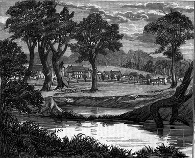
(Above) Dandenong in 1881 (Australian Sketcher)
|
|
 |
|
|
|
|
|
|
|
|
|