HISTORICAL
It is not
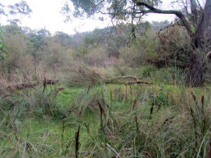
commonly known, but a lagoon once exlsted in the Churchill National
Park, adjacent to the present-day picnic area. The Lagoon is now totally
dry - water entered it via an open channel originating from a long-gone
storage dam high up on the hill near North Boundary Track. The channel, thought to have been built in the mid-1920s,
crossed the disused Dandenong Aqueduct in a 9" pipe - a section of the
pipe survives and passes under the Aqueduct Walking Track. The lower
end of the channel passes beneath Link Track in a cement pipe, near the
HV power line towers.
The Lagoon was
once used for recreation from the late 1940s - a circuit walking track of about
350 m (Nature Walk) now passes through part of the lagoon site - this
starts at the main car-park, and includes three short boardwalks.
Remains of the stone pathway to the Lagoon survive, behind the toilet
block.
Overflow from the
Lagoon was via a gravity-fed watercourse (creek) which started near the present-day
toilet block - this passed under Army Track through a 19" cement pipe,
and continued through the Dandenong Police Paddocks
Reserve to the Dandenong stormwater drain at Brady Rd.
The Army Track crossing is
easily located, immediately adjacent to the barrier gate at the end of
the carpark.
After leaving Army Track, the channel passes under Churchill Park
Drive.
The creek
passed through the site of the 7th Australian Scout Jamboree, held for
nine days in 1964-65 in Police Paddocks Reserve, attended by some 16,000
scouts. Waste water from the campsites entered the creek.
The original site
layout plan for the Jamboree shows a temporary "Jamboree Pump House"
located next to the Army Track undercrossing - this is now in thick
bushland. and is unreachable! It is thought that this contained some
form of mechanical pump to increase the flow from the lagoon, as it is
known that the creek silted up on its way through the Jamboree area.
ALTITUDES
(ASL)
Lagoon (northern boundary near power lines) 82 m.
Undercrossings (all in cement or asbestos pipe)
76 m at Army Track, 74 m at Churchill Park Drive, 68
m at Baden Powell Drive, 55 m at Greystanes Crescent, 50 m at Greenbank Ave, 35 m at Brady Rd. Crossing points may be
inspected, but are not easily found, due to weeds, vegetation, trees, regrowth and land slippage. The most difficult crossing
to locate is on Churchill Park Drive, about 100 m west of Power Rd.
The section of the creek between Greenbank Avenue and Brady Rd passes through bushland known as the "Tree
Conservation Area" - this was established for the Jamboree, and featured a Community Garden
The creek at this point may be viewed, but is now almost buried beneath fallen
trees and dense vegetation. There is evidence that some sections of the walls of the creek had been excavated decades
ago near Brady Rd, possibly for some form of realignment.