HISTORICAL
Modern
Stud Rd runs north-south through the original Police Paddock area, from the Mountain Highway (Bayswater) to McCrae St (Dandenong).
The section of it between Police
Rd and Heatherton Rd is relevant to this Project.
TIMELINE
The future use of the
Paddocks area either side of Stud Rd has long been a source of continuing local community concerns. Innumerable proposals
and suggestions had been advanced to the Government from Shires and citizens, particularly in the decades following the
abandonment of the Police Stud Depot in 1931. Very few of these submissions were accepted. The lower lying area had become
a wasteland, covered with blackberries, noxious weeds and scrub, which persists to the present day!
The
Timeline which includes many of these proposals, gleaned principally from the Argus, the Age, the South Bourke
and Mornington Journal, the Dandenong Journal, the Berwick Shire News, the Commonwealth
Government Gazette, the Port Phillip Government Gazette and the Victorian Government Gazette.
1850s
Stud Rd was planned as a possible
future road and was laid out in the big Land Survey; it was originally a dirt track from what is now Heatherton Rd, ending
at the Dandenong Creek.
1855
Tenders were called for the supply and delivery of ten miles of wooden fencing for the Paddocks, to consist of 6000
posts and 6000 rails.
1862
It was proposed to use the Paddocks for quarantining and testing of diseased cattle
1863
It was proposed that the Paddocks would be used for management of about 200 Alpacas
which had been brought in from Bolivia and 150 lambs. Sadly, most perished.
1866
Large tracts of land were being offered for sale in the Paddocks
1883
Tenders were called for gravelling of of the dirt roadway between the Dandenong
Creek and Dandenong. In May, the Governor in Council approved the construction of a new road from the
Dandenong Creek through to "Fern Tree Gully" and there was a rudimentary log bridge over the Creek. The cost for
this was 300 pounds. This road at the time was known simply as "the main road to Fern Tree Gully". The
name "Stud Rd" was then introduced.
At the same time, a new road was constructed in the Paddocks, from
the "road to Fern Tree Gully" to the Police Depot, at a cost of 200 pounds. The route of this new road is unknown.
1880s
The Govt had reconsidered its position on the future use of the Police Paddocks and
had released large holdings ("Estates") on the western side of Stud Rd for subdivision into small residential allotments.
Roads were planned and named.
There was little interest from potential purchasers due to its proximity to the
Dandenong Creek flood plain and lack of roadways.
1884
There was a proposal for a new rail line from Dandenong
to Ferntree Gully, which would have passed through Police Paddocks, following the general alignment of Stud Rd. This was rejected,
and the new line was built between Ringwood and FTG.
The
original alignment for the line from Dandenong still exists!
1886
A plan was advocated for bulding an agricultural college next to Stud Rd in the lower-lying area of the Paddocks.
This was never implemented.
There was a proposal for a new rail line from
Oakleigh to Ferntree Gully, to follows what is now Ferntree Gully Rd. This never happened!
1894
Trucks
carrying material for relief works in the Paddocks were cited as causing damage to the road.
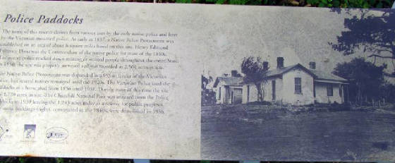
1902
It was proposed that the entire Paddocks area (2000 acres) be
declared as a national park. (Author's note: this proposal was discussed for many years and in 1939
an area of 477 acres was set aside as the Dandenong National Park, gazetted in February 1941, and later renamed
Churchill National Park in 1944).
1913
A proposal was advanced to build a narrow gauge tramline long Stud
Rd from Dandenong to Police Paddocks. This failed.
1914
A proposal as submitted to extgend the Springvale Railway line to the Rowville/Police
Paddocks area. This was never done, and continues to remain unresolved!
1915
A Rifle Range existed in the Paddocks, adjacent to Police
Rd in the NE area - in 1940 it was proposed to extend this and for the access roadway to be gravelled
1918
It was proposd that an area of 1800 acres could be used for resettlement of returned
WW1 soldiers, either on individual blocks or as a village.
1919
In January, a bushfire destroyed some 400 acres of bush and grassland in the Paddocks adjacent to Stud
Rd.
1930
The Govt had proposed leasing
of allotments along the lower sections of the road - hilly areas were to be reserved for recreation. Lower lying areas would
be divided into 50 acre blocks, for 24-year leases, for market gardening. An alternative proposal was for leases to be
used for grazing. A Bill was subsequently approved for leasing 1000 acres of the lower areas of the Paddocks. There was strong
community resistance into the leasing proposal, and arguments were debated in Parliament for retention of the land
as a public reserve.
1931
The first blocks were offered
for lease - two of 64 acres each.
1931
An oil-mining lease had been submitted.
1933
A new bridge over Dandenong Creek had been proposed
1937
Most of the lower area of the Paddocks adjacent to Stud Rd had been stripped of timber. Experiments were carried
out in the Paddocks to assess methods for controlling blackberry infestation.
1938
1100 acres were under lease
1939
Experimental
plots were laid out and planted near the former Police Depot. These were subsequently abandoned - the "Melbourne
1945" aerial photo map shows the extent of this area.
1940
A proposal sought approval for use of 447 acres as a national park, which would consist
of a youth camp, a new access road, hostel, camping ground, warden's quarters, picnic ground, swimming pool, sporting arena,
and childrens' playground. It is unclear as to whether this grandiose proposal related to the lower-lying land or the
hilly areas. This never eventuated and responsibility for it was transferred to an unspecified location in the Lysterfield
area. Due to WW2, the proposal lapsed.
1940
A proposal to plant trees longide the road was rejected due to lack of funds
1940
It was proposed that a "Wild Zoo" be built in the
lower-lying eastern area off Stud Rd. This was never implemented
1948
A new, additional water storage dam was planned for the lower -lying area of the Paddocks,
near the Dandenong Creek/Stud Rd crossing. This was to replace the two dams near Bergin's Rd, as part of the Belgrave to Dandenong
pipeline. This plan was abandoned.
1960
Stud
Rd was straightened between Police Rd and a point next to the present-day Rowville Recreation Reserve. This removed the "kink"
just south of Police Rd. the old road north of Police Rd was retained as a service road.
1979
There was a proposal
to make the lower lying flats of Police Paddocks east of Stud Rd into the Tirhatuan Recreational Park.
This was never actioned, even though it was shown on Melways at the time!
1982
Plans were announced for widening and realigning Stud Rd between Wellington and Police Rds