|
Note: The stories in this
Chapter are extracts of articles in the "Jamboree Daily".
The author has exercised editorial discretion in modification of some
of the original content.
|
|
|
|
| March Past - opening day (From movie, It's a Great Great Game) |
LOCATION
The Camp was sited
on Crown Land - the tented accommodation sections were generally in undeveloped bushland. Administration and
activity areas were mainly in land which had been cleared and stripped of timber in the 1880s.
There were four entrances:
Frankston Drive (Bradfield Rd junction) - the main HQ entrance
Baden Powell Drive north (Bradfield Rd junction) commercial entrance
Baden Powell Drive south (Power Rd junction) - general
entrance for scout arrivals, adjacent to bus drop off and bus parking
Brady Rd (Stud Rd junction) - main entrance, adjacent to public and scouter car parks
ACTIVITY AREAS Principal Activity
Areas were the Main Arena, the Assembly Area, Challenge Valley, Skillorama, and the Jamboree Shopping Centre. The HQ Administration
Area was on the north side of Frankston Drive (from Bradfield Rd) - this included a Reception Area, Hospital, Editorial Office,
a Guests' Camp, Senior and Junior Staff Quarters, and Girl Guides Office.
ACCOMMODATION The Camp was divided into nine sub-Camps, allocated to Troops and Contingents, ranging from three boys to 50+. Other camps were allotted to Headquarters
personnel. Troops were required to set up and take down their own tents, which were provided by the Admin. Each scout
was issued with a Jamboree Blanket and Groundsheet on arrival. Most camps measured four chains by two chains (about
80 metres by 40 metres). Some Troops had larger camps. There were 984 camps - each was numbered. Scouts
used their own sleeping bags, which could be purchased from the Scout Shop. Many camps featured elaborate "Gateways" (entrances),
designed and built by the Scouts.
PLUMBING Water reticulation was planned, installed, and managed by the State Rivers and Water Supply Commission. Usage was
160,000 gallons per day. This included ablution, showers and clothes-washing areas, fresh water for drinking/hygiene/campfires, water
for common services such as activities/canteens, shops, and waste water removal. Taps were installed at
each camp, fed from black PVC pipes from a central supply. Several booster pumps were located around the camp perimeter. The
main Pump House was located in the Churchill National Park, between Army and Bradfield
Rds. Each Troop was required to excavate channels for discharge of waste water, by laying 9" pipes. Before departure,Troops had to remove the pipes and fill in the trenches, and take down the tents.
POWER
240 V AC power was connected to each sub-camp provided
by the State Electricity Commission of Victoria. Power lines were built in 1964, with the main distributions along Bradfield
Rd, Frankston Drive, Baden Powell Drive, Greenbanks Avenue, Belair Avenue and Greystanes Crescent. Power
poles remain in situ today - the month and year of installation,and the height above the ground, are stamped on a small
round plate on each pole. 240V AC was not permitted in accommodation tents. TRANSPORT Scouts arrived at the camp from - shuttle buses originating from Dandenong Railway
Station
- buses from country and interstate locations as arranged by the scout administrations
- private cars
Special trains ran from Flinders St and Springvale Stations to Dandenong
Station.
|
|
|
|
| Coolibah Tent (from movie, Great Great Game) |
COOLIBAH TENTS
Staffed by parents, these were
large marquees located in every subcamp for "rest and recreation". They were community
centres, with games, tables, seats and "cuppas". Films were shown each night,
and scouts could pursue their hobbies there. Talks and displays could be enjoyed,
and scouts could meet and attend to letter writing, reading and personal tasks. (No computers, mobile phones,
tablets or internet then!) PHYSICAL ACTIVITIES
The Challenge Valley was
the main centre, which had many activities, such as the Commando Course, Skillorama,
jumping, rope climbing, running, pipes, contests, and "mud and slush". The Valley was
bounded by Baden Powell Drive, the Lea, and Power Rd - a watercourse passed through it (still there today!) CATERING
Rations
were given out at each sub-camp every morning. Canteens provided the main meals,
using cooking equipment provided by the Army. Scouts were permitted to set
up campfires for cooking "bash and bangers" and making "billy tea"! Refreshments and
supplies could be purchased from the Shopping Area.
|
|
|
|
| TV - ATV0 in Main Arena (from movie It's a Great Great Game 1965) |
RADIO AND TELEVISION
There was a low-powered (ten Watts) AM station known as Jamboree
Radio, operating on 1550 kHz. This was a short-term licence, on the air daily from 6am to 8pm, from the
Press Tent in Frankston Drive, for coverage primarily across the Jamboree precinct. Despite this power limitation, it
was heard quite well around the Melbourne region! Much of the content was news about Jamboree events, activities,
excursions, lost property, lost Cubs (!), etc. Interviews and cheerios from scouters featured prominently, as well as personal
messages. The Wireless Institute of Australia had its own station,
with the calsign VK3WIA, olperating in the 20, 40 and 80 metre bands. This provided a means of two-way contacts with
scouting amateurs primarily across Australia, the Pacific, the Far East and South Asia, and secondarily around the world.
The transmitter, small studio and antenna mast were located on the south side of the Shopping Area (Brady Rd), near the "Lost
Cub Office" and Interstate Contingent camps. No trace of the mast remains - it was dismantled at the conclusion of the Camp
- the actual site is now underneath the Frank Holonin Soccer Facility. TV ATVO
Channel
"0" operated an outside broadcast studio from the Main Arena, which was on the air from 2 pm to 4pm daily. Its primary service
area was the Melbourne metropolitan region. Between 12.30 pm and 2 pm interviews and talks produced by Scouts at the
Jamboree were presented.
COMMUNICATIONSPublic Telephones were located around the camp for calls to Melbourne numbers. Country,
Interstate and Overseas Calls could be made from the Camp Post Office in the Shopping Centre, or from sub-camps.The phones were the black A and B Button design. Money had to be deposited in advance, 2/-, 1/-, and 6d coins
- no change given. The number for incoming calls to the Jamboree was "Dandenong 5 0181"
|
|
NEWSPAPER
This was the Jamboree News, with 27,000 copies
delivered before dawn to the subcamps with rations. It was free, and printed at The Age office, in Melbourne, every day
except Sunday, and was also known as the Jamboree Daily. It's editorial office was in Frankston Drive, just off Bradfield
Rd, next to the Security Hut, and was under the control of a Chief Editor, supported by a staff which included a
photographer, journalists, and cartoonist. Contributions from scouts and subcamps were encouraged. Bound copies
of all of the editions could be ordered by every Scout, for 5/- a set. (Note: The editions may be viewed on-line at the archives of the Dandenong
Advertiser via the NLA-Trove Website - see Link below)
Jamboree News (archive link)
|
|
|
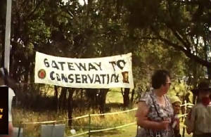
| Tree Conservation Area - 1965 (From "Great Great Game" movie) |
TREE CONSERVATION AND COMMUNITY GARDEN AREA
This was a large area centred on the Creek,
and bounded by Greenbanks Avenue, Brady Rd and the Main Arena. Small saplings and seedlings were planted by the Scouts, and
it was popular on the Visitor Days. Now, some 52 years later, many of the saplings are now mature trees and the descendants
of the saplings have become wild shrubs and bushes. Sadly, some of the trees have died, as the creek no longer flows. The
area is now best reached from narrow unformed and unsigned pathways starting at the corner of Brady Rd and Greenbanks Avenue.
The Creek is now almost buried under blackberries, thistles, fallen branches, and dead trees.
|
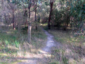
| Foottrack to Conservation Area (author, July 2017) |
|
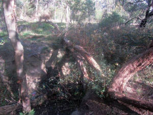
| Overgrown Creek in Conservation Area (author, July 2017) |
|
|
 |
|
|
|
|
|
|
|
|
|


