|
|
|
| Commandant's residence 1925 (SLV) |
|
|
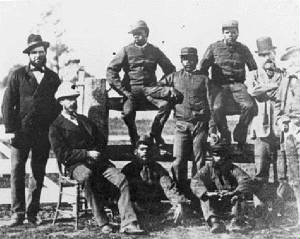
| Blacktrackers from Queensland, 1979 ( SLV) |
The
Paddocks date back to the early 1830s, and
is on Crown Land, jointly managed by Parks Victoria and the City of Casey. In the
past, the area was part of the former Cities of Berwick and
Dandenong. In October 1837,
Captain William Lonsdale, who was in charge of the
infant settlement, directed that land in the district of “Nerre Nerre
Warrene” be set aside for a depot for a native police corps. Early
survey maps show this land to have covered an area of about six square
miles.
Note:
The modern official (Landvic) name is Nerre Nerre Warren, also shown in some resources as "Narree
Worran" ) It extended from the present line of Police Road in the north to
Heatherton Road in the south (known as the Mornington Rd in the late 1880s) and from the present Gladstone
Road to the
west (in present-day Dandenong North) to deep into the Lysterfield Hills to the north-east. The depot itself was established
on a hill east of what was then
called the “Dangynon” or “Dangy Nong” Creek in what became known as the Police
Paddocks.
It originally included the area to the west of present-day Stud Rd to Gladstone Rd (now occupied by residential
housing, the Tirhatuan Lake, Tirhuatan Wetlands and Tirhatuan Public Golf Course), and north-east to the land which became
the Churchill National Park. The eastern boundary was on the western edge of what became the Churchill Park Golf Course.
The
original boundaries were ill-defined, mainly because there were very few made roads in the 1830s, and the land was broken
up into large holdings (runs)divided into grids following surveying. The region was centred on the Dandenong Creek Valley.
Note that the original Police Paddock was created solely for recreational use, in
perpetuity, and was never to be used for residential or commercial development, except under "special circumstances". Exceptions to this occurred decades later when some allotments were opened up
in the area between what is now Stud and Gladstone Rds, and on the south east corner of Stud and Brady Rds.
The
present-day (2017) area is about 499 hectares, with boundaries being Stud Rd, Police Rd, Churchill Park Drive, the
western fence of the Churchill Park Golf Course, part of the Sydney Pargeter Recreation Reserve, Kennington Park
Drive, Essex Park Drive, Monash Freeway, and the Dandenong Creek. Some of it is fenced.
The gated roadways in the hill area were constructed In 1962/63 for the 7th Australian Scout Jamboree -
most have been retained for fire management purposes and as walking tracks. These are Brady Rd extension, Baden Powell
Drive, Belair Ave, Landsdowne Rd, Greenbanks Avenue, Clifford Park Drive, Frankston Drive, Greystanes Crescent.
|
EARLY ACTIVITY According to the Victoria
Government Gazette, first published in 1851, the earliest reference to the Police Paddocks was in January
1855, when tenders were called for the delivery of 6000 posts and 6000 rails for construction of a perimeter fence around
the "Dandenong Paddock Enclosure". This had originated from the Office of the Chief Commissioner of Police. It indicated
that timber for splitting was available from a nearby paddock. and that a bullock team and dray would be placed at the
disposal of the contractors. The total area to be fenced was about 2000 acres (about 810 ha), with a perimeter of some
9 miles (15 km).
It is noted that the original
name of the area was "Dandenong Police Paddock", which subsequently became "Dandenong Police
Paddocks"
|
|
|
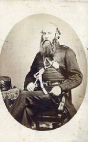
| Captain Dana, 1879 (SLV) |
HISTORICAL BACKGROUND
Aboriginal people knew the location of Dandenong Police Paddocks as Nerre
Nerre Warrene. It was part of the lands of the Bunurong Aboriginal people. Today
members of the Wurundjeri community of Melbourne are involved in park management
and recovering Aboriginal heritage. It's an area of sloping land along a ridge
overlooking the Dandenong Creek and river flats. It includes the surface and
subsurface remains of several occupations from the 1830s.
The town of Melbourne was founded in 1835, and the land to the south-east
was extensively cleared, stripped of trees, drained, furrowed and fenced. In the
1830s the area was known as the Dandenong Paddock, originally about 1800 acres. There were five buildings of wattle and daub
with bark roofs
constructed at this time.
It subsequently became known as the Dandenong Police Paddocks.
1837-1838
The headquarters of the first Native Police Corps commanded by Christian de
Villiers was stationed here. The Corps, consisting of Aboriginal men, were
involved in dealing with disputes between Aboriginal and European people across
Victoria
1840 - 1843
The Melbourne-Westernport Aboriginal Protectorate Station was here.
1843 to 1853
The headquarters of the second Native Police Corps, commanded by Henry
Pultney Dana was stationed here.
The Native Police were also the first police stationed on the goldfields
and they acted as guards at Pentridge Prison at Coburg.
1853 - 1931
The Victoria Police Horse Stud Depot was located here.
1879 - 1963
Aboriginal people worked as trackers with the Victorian Police in this era.
Until 1931, many of the trackers were based with the Victorian Police Horse Stud
Depot in the Reserve.
1960s
The Narrandjeri Wurundjeri Park was set aside, as a permanently preserved
area within the Police Paddocks, following representation by the Kulun peoples,
the traditional owners.
|
|
|
| Site of Native Police Corps HQ (author 2017) |
PHASES OF PRINCIPAL LAND USAGE - TIMELINE - October 1837 to January 1838 - the headquarters of the first Native Police
Corps commanded by Christian de
Villiers
- 1840 to 1843 - the Westernport Aboriginal Protectorate
Station
- 1843 to 1853 -.the headquarters of the second
Native Police Corps, commanded by Henry
Pultney Dana
- 1853 to 1930 - the Victoria Police
Horse Stud Depot
- 1860s - land sales
- 1930 to 1957 - farming, grazing, and agriculture
- 1941
- Dandenong National Park formed, in the north section of the land, renamed Churchill
National Park in 1944
- Dec 1964 to Jan 1965 -7th Austraiian
Scout Jamboree
- 1965 to present - walking trail
network (managed by Parks Victoria since 1998)
- 1960s to present
- recreational areas
- 1978 to present - Dandenong Softball Association
- 1980 to
present - Frank Holohan Soccer Centre
|
FRIENDS OF THE DANDENONG POLICE PADDOCKS
The Committee of Management of this community group was officially
incorporated on July 28, 1992, and dissolved on July 26, 1997.
In its short lifetime the group had planted
thousands of native
plants, rehabilitated a wetland area, constructed and installed
nestboxes and participated in many Clean Up Australia days. The regular
planned activities were designed to allow people of all ages to enjoy and
participate in the protection of the reserve.
The group produced a quarterly newsletter that listed upcoming
events and activities and kept members in touch with the latest
developments in the management of the Dandenong Police Paddocks Reserve.
Members of the group ranged in age from five to 80 and came from all
walks of life.
|
SUB-LEASING Since
the mid-1960s, several areas
of the Paddocks have been made available on a long-term basis to various sporting,
recreational, and cultural organizations, principally: Australian Softball Centre (off Brady Rd) Rowville
Recreation Reserve (off Stud Rd) Aimee Seebeck Sporting Centre
(off Police Rd) Frank Holohan
Soccer Complex (off Baden Powell Drive) Soccer Field (off Brady
Rd) Kooronga Camp Girl Scouts Australia (off Baden
Powell Drive) Robinson
Reserve (Boy Scouts) (off Churchill Park Drive) Narrandjeri-Wurundjeri
Aboriginal Park (off Brady Rd) Melbourne Water Retarding Basin (off Baden Powell Drive)
Council tips existed for short-term periods, located
off Brady Rd and Baden Powell Drive. COMMUNICATIONS
TOWER A mobile telephone tower is located off Baden Powell Drive, in
bushland, near Churchill Park Drive. LOCATION SIGNS These
are located at - Cnr of Police Rd and Churchill Park Drive
- Entrance to Frankston Drive, off Churchill Park Drive
- Northern Entrance to Baden Powell Drive. off Churchill Park Drive
- Southern
Entrance to Baden Power Drive, off Power Rd
- Entrance
to Sydney Pargeter Recreation Reserve, off Power Rd
- Brady Rd,
next to Dandenong Creek bridge
- Stud
Rd, opposite Tirhatuan Golf Course
- Police Rd, opposite
entrance to East Rowville Terminal Station

WATERCOURSES
Recent
excavations in support of investigatory research by local Government examining historical land usage has revealed the existence
of many buried pipes in the flood-plain area bounded by Stud Rd, Churchill Park Drive, and Police Rd. The Photomap of "Melbourne 1945" shows some of these channels,
which originated in the higher ground in what is now Churchill National Park. The resolution of these surface features
is limited by imperfections in the technology of the day, decades before Google Earth appeared!
|
(Above) Original boundaries in red (approx.) in
1838 - 15 km perimeter - 1600 hectares (author)
|
|
Nominal present day boundaries of the Police Paddocks Reserve - 9.1 km - 500 hectares
(author)
|
|
|
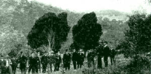
| Government inspection of future NP site, May 1907 (Argus) |
From the early 1900s, community
agitation had been increasing for the creation of a new public park in the Paddocks area. In 1939, 670
acres (271 hectares) was reserved for a new National Park, which became the Dandenong
National Park in 1941, and renamed Churchill National Park in 1944. Churchill NP thus
became divorced from Police Paddocks, as a separate entity.
|
|


