Dandenong Police Paddocks and Churchill NP - Pictorial Heritage 1837 to 2017

1942-1946 Rowville Military Camp

Home
History
History of Melbourne
Geomorphology
Early Settlement
1837 Native Police Corps 1837-1838, 1843-1853
Westernport Aboriginal Protectorate 1840-1843
1840 Tirhatuan Land
1853 Victoria Police Horse Stud Depot 1853-1930
1893 Belgrave-Dandenong Pipeline
1912 Scoresby Tramway
1920s Churchill National Park - the Lagoon
1941 Churchill National Park
1915 - Dandenong Aqueduct
1946 Heany Park Lake
1942-1946 Rowville Military Camp
1964-1965 Jamboree - Information
1964-65 Jamboree - The Site
1964-1965 Jamboree Site Plan
1964-65 Jamboree - the Logistics!
1964-65 Jamboree - Around the Camp
1964-1965 Jamboree Action (Part 1)
1964-1965 Jamboree Action (Part 2)
1964-65 Jamboree Action (Part 3)
1964-1965 Jamboree Actions (Part 4)
1964-65 Jamboree Visitors' Days
1964-65 Jamboree - Religious Observances
1964-65 Jamboree Internal Roadways
1964-65 Jamboree Roadways - Baden Powell Drive
1964-65 Jamboree Roadways - Clifford Park Drive
1964-65 Jamboree Roadways - Frankston Drive
1964-65 Jamboree Roadways - Belair Avenue
1964-65 Jamboree Roadways - Greenbank Avenue
1964-65 Jamboree Roadways - Greystanes Crescent
1964-65 Jamboree Roadways - Lansdowne Rd
1964-65 Jamboree Movie Show!
Woodland Walk and Lagoon
Road History - Police Rd
Road History - Brady Road
1964-65 Jamboree - Shopping and Exhibition Area
Road History - Stud Rd Precinct
Southern Police Paddocks Land
Road History - Churchill Park Drive
Road History - Gladstone Rd
Road History - Heatherton Road
Road History - Power Road
Scout Camps and Reserves
Melbourne Water Retarding Basin
Narrandjeri Wurundjeri Park
Walking Tracks
Proposals and Plans
Epilogue
Suggestions for Investigation and correction
About the Author
About the Author
References

starlight1.jpg
Commemorative Plaque in Starlight Reserve (author 2017)

HISTORY
Rowville Military Camp / POW Camp was built in 1942 and was decommissioned in 1946. Australian troops of the 3rd Motor Brigade moved in during May 1942.

The camp was sited on a 109 hectare area on the south-west corner of Wellington and Stud Rds, north of present Timbertop Drive. It was at the edge of the original northern boundary of Police Paddocks.

The Camp included an area of 3.2 ha on its southern boundary now known as the Starlight Reserve,  which is now a bushland park, featuring a circuit walking track, with info boards about Aboriginal culture and traditions.  An elegant modern commemorative Plaque marking the location of the Camp is located at the main entrance to this reserve, sponsored by the Knox Remembrance Day Committee.

The troops were to be used as a strategic reserve in the event of a Japanese invasion in the Westernport region. When the likelihood of such an event passed, the soldiers were moved out.

1942
In September, Australian soldiers were replaced by American troops.

1942
Construction of the facility was assisted, on Sundays, by volunteer workers, carpenters, and tradespersons from the YMCA Red Shield organization.

Access to the site was from several entrances along Wellington and Stud Rds. Security was reported to be lax, and POWs were not permitted to venture past the Dandenong Creek.

1944
When the Americans went off to the Pacific war zones their places in the camp were taken by Italian Prisoners of War who had been captured in North Africa.

1945
By June, the number of prisoners had grown to about three hundred and the role of the camp was changing to that of a staging camp. This meant that all Italian prisoners being moved from camp to camp or on to farms as labourers were processed in Rowville. A total of two thousand six hundred prisoners passed through the Rowville camp.

1946
The last of the prisoners were repatriated to Italy.

1947
January - public tenders were called for the dismantling and removal of all above-ground infrastructure. Some of the POW huts were relocated to the Churchill National Park for use as hostel accommodation.

1947
Regular motor cycle races were held on the site until 1949 - attendances of 3000 were reported.

1947
An extensive and wide-ranging Commission of Enquiry took place into the management of the facility, associated with the health and well-being of the POWs.

1950
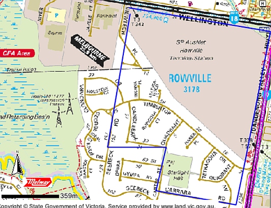
The Rowville Terminal Power Station was built on the northern section of the site. The southern section was associated with residential development.

Present day
Remains of the camp consist of fourteen concrete building foundations, a 24,000 gallon steel storage tank foundation and a concrete culvert. These artefacts are within the Power Station property.

police-paddocks-pow-aerial-photo-1945.jpg

(Above) Greatly magnified view of the Rowville POW Camp, from the "Melbourne 1945" aerial photo (Melbourne Uni.) The white lines are roadways in the compound. Wellington Rd is at right image, Stud Rd right of centre. Bergin's Rd runs diagonally from the junction of Wellington and Stud Rds.

police-paddocks-pow-camp2017-map.jpg

Map from Landvic (2017) showing approx boundaries of the POW Camp (in blue) (author)

police-paddocks-powerstation-rowville-googleview.jpg
Power Station seen from Wellington Rd (author, May 2017)

starlight-apr-2017.jpg

Click on any image to display a full-sized view!