|
(Above) May 9, 1907 - dignatories on an inspection of
the area which would ultimately become the Churchill National Park. Looking north towards Lysterfield Hills. (From the Argus)
|
|
|
|
| Remains of the old granite quarry, adjacent to Stonemason's Track (author, May 2017) |
HISTORICAL
The property which is now Churchill National
Park was once part of the original Dandenong Police Paddocks. At creation It was 477 acres (193 ha.) It
is now 271 hectares (670 acres). It borders Lysterfield Park (3427 acres - 1387 ha) In the 1920s, metropolitan development had brought some change to land usage.
Local stone was
dug up for road metal and building material, a water supply channel was
cut to Dandenong in 1922, and the State Electricity Commission obtained a power
line easement in 1921. Fire and the clearing of the area took place in later years..
In 1939
the area was set aside as the Dandenong National Park, gazetted in February 1941, and later renamed Churchill
National Park in 1944.
The Park was created as the outcome of community agitation from as early as the
late 1890s, but a succession of Governments declined to progress the proposal until the mid-1930s. It was
originally hoped that the Park would be used as a National Fitness Centre, featuring hostel-type accommodation,
a swimming pool, sporting areas, picnic ground, warden's area, wild zoo, children's playground, tennis courts,
equestrian centre,camping ground, and landscaped gardens. Very few of these attractions were built. The Park is actually part of the Lysterfield Hills. Six high voltage power lines traverse Churchill National Park,
and another line traverses Lysterfield Park adjacent to Logan Park Track.
Telstra and Optus underground fibre optic cables also traverse Churchill National Park in the vicinity of the
power lines.
|
|
(Above) - 2017 map (Landvic), centred on the main access gate.
|
|
| Kangas on Bayview Track (author, May 2017) |
WALKING TRACKS
Several
gated fire management roads were constructed in the 1970s and made available for walkers. Some of these also
provide maintenance access for the transmission lines and communication cables. Walking trails radiate out from the main picnic area. The track to Trig Point
Lookout is steep; but excellent views are obtained from the summit. Pedestrian access in to the Park is
also available from tracks - originating in Lysterfield
Park
- at the eastern boundary at Bay View
Track
- at the western boundary at Army
Rd
- at the northern boundary at Bellbird Track
Note: Some reports in the newspapers of the 1940s
used the term "Dandenong Police Paddocks" to refer to the National Park. PEDESTRIAN CROSSING
The current (2017) Management Plan for Churchill NP/Lysterfield Park indicates that a
safety crossing for pedestrians is proposed for Churchill Park Drive, to be
located opposite the main gate. VEHICLE ACCESS
The main public gate is located about 100 metres east of the Power
Rd roundabout, opposite the Churchill Park Golf Course. Opening and closing
times vary throughout the year. This follows Army Rd to the main car park and visitor centre. Until 1972, the main
vehicle access was from a gate to the west of the roundabout, as a continuation of
Power Rd - this gate entry no longer exists, and is now a secondary
car park next to the picnic area. Public access between 1964 and 1972 was also available by a
short roadway from what is now Churchill Park Drive, as a continuation of Frankston Drive. Part of this is now a small car
park adjacent to the visitor centre. From the mid-1940s the only vehicular
access to the Park was via Army Rd, starting at Bergin's Rd. Private vehicle access to Army Rd is now blocked by barriers
at the end of the visitor centre, and at Bergin's Rd, but pedestrian access is permitted.
Army Rd was built in 1943, using resources and labour from the Australian Government Military
Camp near the south-west corner of Stud and Wellington Rds.
|
BUSHFIRES A large bushfire raged on January 19, 1973, destroying about 500 acres
of bushland in the Churchill National Park and the Memorial Gates of the Scout Camp (built
in 1946) at the eastern end of the Park. This was known as the Lysterfield Fire, which was believed to have been
started by an arsonist. That fire also burnt out some 756 acres of forest in the Lysterfield catchment
area, centred on Logan Park Rd.
Thr most serious recent fire
occurred on Black Saturday, on February 9, 2009. This destroyed
a large area of the Churchill Natkional Park, adjacent to Churchill Park Drive, and
all of the Robinson Scout Reserve next to the Golf Course. It was contained just before
it reached the high voltage transmission line firebreak.
Another serious bushfire raged on Ash Wednesday 1983, destroying much of the Churchill/Lysterfield Park area.
|
|
|
|
| The Standpipe (July 2017,author) |
WATER STANDPIPE
Visitors to the picnic area may notice an
old metal pipe structure (about three metres tall) standing on the south edge of Army Track, opposite the Information
Board. It is the remains of a "Water Standpipe", which was used to fill water tankers from what is believed to be a now
disused underground main pipe. This was used when Bradfield Road was being built in 1963 (for the Scout Jamboree)
for dust mitigation purposes - at that time the road was unsealed. The Pipe is similar to those used to refill the
tenders of steam locomotives. It originally had a swinging arm and hose at the top.
|
|
(Above) Map showing perimeter of the Black Saturday (2009)
bushfire. (Geoscience Australia)
|
|
|
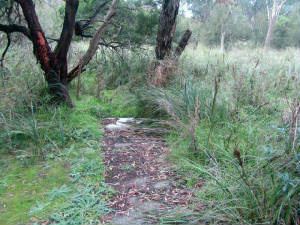
| Old stone pathway to Lagoon (author, June 2017) |
THE LAGOON It
is not commonly known, but a lagoon once existed in the flatter land ato the north of the present-day picnic area. This
is now totally dry and cannot be easily identified. The present-day Nature Trail, starting at the Picnic Ground, follows
the general perimeter of the old lagoon. Three small boardwalks allow access across a dry watercourse which once took water
via an open channel high up on the hill in the north. This watercourse crossed the old Dandenong Aqueduct and adjacent
Channel Track in a 9" metal pipe, which is still there.
The watercourse crosses under Bay View Track in a cement pipe.
It is difficult to find, now almost buried in vegetation,
weeds, and small trees. It entered the former lagoon near the present-day Nature Trail, beneath the HV power lines.
The lagoon apparently dried up in the mid-1960s.
|
Central and western sections of Churchill NP - 2017 (Parks Vic)
|
 |
|
|
|
|
|
|
|
|
|


