Dandenong Police Paddocks and Churchill NP - Pictorial Heritage 1837 to 2017

1915 - Dandenong Aqueduct

Home
History
History of Melbourne
Geomorphology
Early Settlement
1837 Native Police Corps 1837-1838, 1843-1853
Westernport Aboriginal Protectorate 1840-1843
1840 Tirhatuan Land
1853 Victoria Police Horse Stud Depot 1853-1930
1893 Belgrave-Dandenong Pipeline
1912 Scoresby Tramway
1920s Churchill National Park - the Lagoon
1941 Churchill National Park
1915 - Dandenong Aqueduct
1946 Heany Park Lake
1942-1946 Rowville Military Camp
1964-1965 Jamboree - Information
1964-65 Jamboree - The Site
1964-1965 Jamboree Site Plan
1964-65 Jamboree - the Logistics!
1964-65 Jamboree - Around the Camp
1964-1965 Jamboree Action (Part 1)
1964-1965 Jamboree Action (Part 2)
1964-65 Jamboree Action (Part 3)
1964-1965 Jamboree Actions (Part 4)
1964-65 Jamboree Visitors' Days
1964-65 Jamboree - Religious Observances
1964-65 Jamboree Internal Roadways
1964-65 Jamboree Roadways - Baden Powell Drive
1964-65 Jamboree Roadways - Clifford Park Drive
1964-65 Jamboree Roadways - Frankston Drive
1964-65 Jamboree Roadways - Belair Avenue
1964-65 Jamboree Roadways - Greenbank Avenue
1964-65 Jamboree Roadways - Greystanes Crescent
1964-65 Jamboree Roadways - Lansdowne Rd
1964-65 Jamboree Movie Show!
Woodland Walk and Lagoon
Road History - Police Rd
Road History - Brady Road
1964-65 Jamboree - Shopping and Exhibition Area
Road History - Stud Rd Precinct
Southern Police Paddocks Land
Road History - Churchill Park Drive
Road History - Gladstone Rd
Road History - Heatherton Road
Road History - Power Road
Scout Camps and Reserves
Melbourne Water Retarding Basin
Narrandjeri Wurundjeri Park
Walking Tracks
Proposals and Plans
Epilogue
Suggestions for Investigation and correction
About the Author
About the Author
References

policepaddocksaqueductmap.jpg

(above)  Route of Aqueduct (author, based on Google Maps, 2017)

police-paddocks-syphon-track1.jpg
Exposd Pipe on Syphon Track (author, March 2017)

churchill-mar-20-2017-027.jpg
Channel Track (author, March 2017)

AQUEDUCT TO DANDENONG

This was constructed in the 1915-1920 era. It consisted of an open-channel aqueduct and underground pipe, fed from a dam in the north-west of the Churchill National Park and descended about 3 km to the east.

The open section ended at the junction of Bayview Track and Stonemason's Track, where it entered a syphon, in a pipe. The pipe crossed what is now Churchill Park Drive, and continued south as an open channel to two retarding dams in what is now the Churchill Park Golf Club. Surviving sections of the pipe are visible next to Syphon Track.

The former management roadway is now a walking track, known as Channel Track, and can be followed from the old damsite all the way to the start of the syphon.

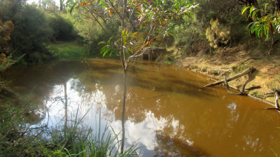
The old dam still exists, and can be reached by following Army Rd to Channel Track, then along a short bushland track. Rainwater and run-off still collects in the dam, and its overflow passes through the original stone/brick structure into the aqueduct.

There is no longer any actual flow along the aqueduct, as it is blocked by weeds, shrubs, vegetation and trees which have taken over! Its main use is as a watering hole for kangaroos!

Channel Track can be easily reached and inspected adjacent to the Park picnic ground, by following Shelter Track or Kangaroo Track.

The pipe actually continues underground in the Golf Club grounds; It then joins to another disused pipe, which crosses Power Rd, then on to Dandenong.

It was decommissioned In 1936 when the Lysterfield Reservoir was opened, and a new pipeline to Dandenong was introduced.


police-paddocks-syphon-track3.jpg
Syphon Track (author, 2017)

police-paddocks-syphon-track2.jpg
Syphon Pipe (author, March 2017)

dam.jpg

(Above) The Dam, May 2017 (author)

channel-track-may2017.jpg
Channel Track and Aqueduct (author, May 2017)

channel-track-apr.jpg
Channel Track (author, May 2017)

Click on any image to display a full-sized view!